Dorst

Last updated

Dorst
Village
520024 Sint-Marculphuskerk.jpg
St Marculphus Church
2010-NL-P10-Noord-Brabant-positiekaart-gemnamen.jpg
Red pog.svg
Dorst
Location in the province of North Brabant in the Netherlands
Netherlands location map.svg
Red pog.svg
Dorst
Dorst (Netherlands)
Coordinates: 51°35′26″N4°51′28″E / 51.5906°N 4.8578°E / 51.5906; 4.8578 Coordinates: 51°35′26″N4°51′28″E / 51.5906°N 4.8578°E / 51.5906; 4.8578
Country Netherlands
Province North Brabant
Municipality Oosterhout
Area
[1]
  Total17.68 km2 (6.83 sq mi)
Elevation
[2]
8 m (26 ft)
Population
 (2021) [1]
  Total3,310
  Density190/km2 (480/sq mi)
Time zone UTC+1 (CET)
  Summer (DST) UTC+2 (CEST)
Postal code
4849 [1]
Dialing code 0161

Dorst is a village in the municipality Oosterhout, in the Dutch province North Brabant. Dorst is located near Rijen and the nearest cities are Breda, Oosterhout and Tilburg.

Contents

Toponymy

The name Dorst is supposed to originate from Dornt, which would refer to meidoorn, that was used as plot separation.

Another explanation is a contraction of the words "De Horst".

History

Dorst was first mentioned in 1290, then in 1323 and thereafter more regularly. Willem van Duivenvoorde was the lord of Kasteel Strijen in 1325 and thus also of Dorst.

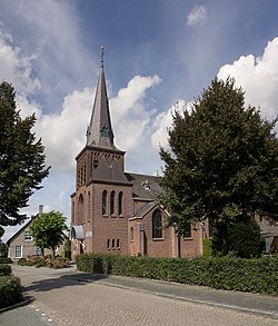
In 1511 the chapel of Dorst was first mentioned. The chapel was devoted to the Holy Trinity. In 1648 the chapel had to be closed and it feel into disrepair. In 1675 the Catholics could use a barn church instead. In 1689 there was a Saint Marcouf relic donated, which made Dorst into a sanctuary. In 1835 there was built a church across from the chapel. The chapel was demolished after that. In 1912 the church was also demolished and the current Sint-Marculphuskerk was built.

Dorst was poor: north of the town there was barren soil and south of the town there was a swampy area called 'het Goor'. To provide for the life maintenance the people devoted to goat breeding. Goats also produced milk, that milk was of great importance for the health of the people in the town.

In 1888 the Seterse Heide was designated as a catchment area and in 1894 the waterworks was built. The railway alongside Dorst was opened in 1867, but Dorst did not get a station. However, from 1908 to 1930 there was a stopping place for the trains. North of the railway, at De Vliert 20, there was a brickyard. This was established at 1899 by Frans Oomen. The factory possessed a Hoffmann kiln and produced 5 to 6 million stones a year. For some time there also functioned a roof tiles factory. The stone factory was demolished in 2010 after a time of vacancy.

In 1931 the Franciscans of Etten settled in Dorst. They provided the nursery school and the education for girls.

Already before World War II the tourism grew. Especially the in Boswachterij Dorst located Natuurbad Surae attracted people. There were also simple group accommodations created, named camping houses. Those houses have become out of use.

Sightseeings

Nature and landscape

North of Dorst there is the vast Boswachterij Dorst, a forest and nature area on the former Seterse Heide. South of Dorst there is a large-scale open agriculture area.

Services

There is education on the elementary school Marcoen. Dorst is accessible via N282 and the A27. Bus transportation is done by Veolia Transport Nederland:

Near cities

Teteringen, Breda, Oosterhout, Rijen, Molenschot, and Bavel.

Related Research Articles

<span class="mw-page-title-main">Tilburg</span> City and municipality in North Brabant, Netherlands

Tilburg is a city and municipality in the Netherlands, in the southern province of North Brabant. With a population of 222,601, it is the second-largest city or municipality in North Brabant after Eindhoven and the seventh-largest in the Netherlands as a whole.

<span class="mw-page-title-main">North Brabant</span> Province of the Netherlands

North Brabant, also unofficially called Brabant, is a province in the south of the Netherlands. It borders the provinces of South Holland and Gelderland to the north, Limburg to the east, Zeeland to the west, and the Flemish provinces of Antwerp and Limburg to the south. The northern border follows the Meuse westward to its mouth in the Hollands Diep strait, part of the Rhine–Meuse–Scheldt delta. North Brabant has a population of 2,562,566 as of November 2019. Major cities in North Brabant are Eindhoven, Tilburg, Breda and its provincial capital 's-Hertogenbosch.

<span class="mw-page-title-main">Tiel</span> Municipality in Gelderland, Netherlands

Tiel is a municipality and a town in the middle of the Netherlands. The town is enclosed by the Waal river and the Linge river to the South and the North, and the Amsterdam-Rhine Canal to the East. Tiel comprises the population centres Kapel-Avezaath, Tiel and Wadenoijen. The city was founded in the 5th century CE.

<span class="mw-page-title-main">Oirschot</span> Municipality in North Brabant, Netherlands

Oirschot is a municipality and a town in the southern Netherlands. It is situated 12 kilometres (7.5 mi) from the city of Eindhoven and 20 kilometres (12 mi) from the city of Tilburg in the province North Brabant (Noord-Brabant). The municipality had a population of 18,842 in 2021.

<span class="mw-page-title-main">Oosterhout</span> Municipality in North Brabant, Netherlands

Oosterhout is a municipality and a city in the southern Netherlands. The municipality had a population of 56,206 in 2021.

<span class="mw-page-title-main">Zundert</span> Municipality in North Brabant, Netherlands

Zundert is a municipality and town in the south of the Netherlands bordering Belgium, in the province of North Brabant.

<span class="mw-page-title-main">Breda</span> City and municipality in North Brabant, Netherlands

Breda is a city and municipality in the southern part of the Netherlands, located in the province of North Brabant. The name derived from brede Aa and refers to the confluence of the rivers Mark and Aa. Breda has 185,072 inhabitants on 13 September 2022 and is part of the Brabantse Stedenrij; it is the ninth largest city/municipality in the country, and the third largest in North Brabant after Eindhoven and Tilburg. It is equidistant between Rotterdam and Antwerp.

<span class="mw-page-title-main">St. John's Cathedral ('s-Hertogenbosch)</span> Church in s-Hertogenbosch, Netherlands

The Catholic Cathedral Church of St. John (Sint-Janskathedraal) of 's-Hertogenbosch, North Brabant, is the height of Gothic architecture in the Netherlands. It has an extensive and richly decorated interior, and serves as the cathedral for the bishopric of 's-Hertogenbosch.

<span class="mw-page-title-main">Helvoirt</span> Village in North Brabant, Netherlands

Helvoirt is a village and part of the municipality of Vught, Netherlands.

<span class="mw-page-title-main">Galder, Netherlands</span> Village in North Brabant, Netherlands

Galder is a village in the Dutch province of North Brabant. It is located in the municipality of Alphen-Chaam 8 km south of the city of Breda.

<span class="mw-page-title-main">Bavel, Netherlands</span> Village in North Brabant, Netherlands

Bavel is a village in the southern Netherlands. It is located in the Dutch province of North Brabant, largely within the municipality of Breda with some rural areas in the municipality of Alphen-Chaam.

<span class="mw-page-title-main">Rijen</span> Town in North Brabant, Netherlands

Rijen is the largest place in the Dutch municipality of Gilze en Rijen. The city hall is located here. Rijen is situated north of the A58, between Breda and Tilburg. Surrounding places are: Dorst, Dongen and Oosterhout.

<span class="mw-page-title-main">Sint Nicolaasga</span> Village in Friesland, Netherlands

Sint Nicolaasga is a village in the Dutch province of Friesland. It is located in the municipality of De Fryske Marren, and had a population of around 3330 in 2017.

<span class="mw-page-title-main">Tilburg railway station</span>

Tilburg railway station is a railway station located in Tilburg in the province of North Brabant, Netherlands. The station was opened on 5 October 1863 and is located on the Breda–Eindhoven railway and Tilburg–Nijmegen railway. The train services are operated by Nederlandse Spoorwegen (NS).

<span class="mw-page-title-main">Brabantine Gothic</span> Variant of Gothic architecture that is typical for the Low Countries

Brabantine Gothic, occasionally called Brabantian Gothic, is a significant variant of Gothic architecture that is typical for the Low Countries. It surfaced in the first half of the 14th century at St. Rumbold's Cathedral in the City of Mechelen.

<span class="mw-page-title-main">Rijksstraatweg</span>

Rijksstraatweg or simply Straatweg was the term for paved roads of interregional significance in the Netherlands in the 19th and early 20th centuries. These roads were built by the national government, and formed the country's first centrally planned highway network. They received route numbers, eventually resulting in a nationwide network of 82 highways. It formed the basis for today's system of nationally controlled roads, the Netherlands' main highway grid.

<span class="mw-page-title-main">Nijnsel</span> Village in North Brabant, Netherlands

Nijnsel is a village in the province of North Brabant, located in the Meierij of 's-Hertogenbosch. Nijnsel is a parish of the municipality of Meierijstad.

<span class="mw-page-title-main">Rijkevoort</span> Village in North Brabant, Netherlands

Rijkevoort is a church village with more than 1600 inhabitants. Until 1942, Rijkevoort together with Beugen formed the municipality of Beugen en Rijkevoort. This municipality was then split and Rijkevoort joined the municipality of Wanroij. Since the municipal reorganization of 1 January 1994, most of Rijkevoort belonged to the municipality of Boxmeer. The neighbourhood Rijkevoort-De Walsert was then added to the municipality of Sint Anthonis. Since 2022 Boxmeer and Sint Anthonis have been part of the new municipality of Land van Cuijk.

<span class="mw-page-title-main">Wilhelmina Canal</span>

The Wilhelmina Canal is a canal in North-Brabant, Netherlands. It connects Tilburg to the Meuse, and continues to the east to connect to the Zuid-Willemsvaart north of Helmond.

References

  1. 1 2 3 "Kerncijfers wijken en buurten 2021". Central Bureau of Statistics. Retrieved 18 April 2022.
  2. "Postcodetool for 4849AC". Actueel Hoogtebestand Nederland (in Dutch). Het Waterschapshuis. Retrieved 18 April 2022.