Lage Zwaluwe | |
---|---|
Village | |
Coordinates: 51°42′29″N4°42′12″E / 51.70806°N 4.70333°E Coordinates: 51°42′29″N4°42′12″E / 51.70806°N 4.70333°E | |
Country | Netherlands |
Province | North Brabant |
Municipality | Drimmelen |
Area | |
• Total | 23.58 km2 (9.10 sq mi) |
Elevation | 1.2 m (3.9 ft) |
Population (2021) [1] | |
• Total | 4,110 |
• Density | 170/km2 (450/sq mi) |
Time zone | UTC+1 (CET) |
• Summer (DST) | UTC+2 (CEST) |
Postal code | 4926 [1] |
Dialing code | 0168 |
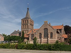
Lage Zwaluwe is a village in the municipality Drimmelen, North Brabant, the Netherlands. The Lage Zwaluwe railway station and the Moerdijk bridges lie to the west of the village.
The village was first mentioned in as 1291 Zwaluwe, and means whirling, rushing river. Laag (lower) has been added by distinguish from Hooge Zwaluwe. [3] Lage Zwaluwe developed as a linear settlement along the dike of the Grote Hollandse Waard. [4]
The Dutch Reformed church dates from 1816 and was extended in 1867. The Catholic St John the Baptist church was built in 1951 and contains three 17th century Flemish paintings. [4]
Lage Zwaluwe was home to 1,241 people in 1840. [5] In 1866, the Lage Zwaluwe railway station opened. The original station building was destroyed in 1945. In 1950, a small building was constructed. It was demolished for the construction of HSL-Zuid, the high speed railway line. In 2003, a glass air bridge was built. [6]
Lage Zwaluwe used to be part of the municipality of Hooge en Lage Zwaluwe. In 1996, it was merged into Drimmelen. [5]
Drimmelen is a municipality and a town in the southern Netherlands, in the province North Brabant.
Moerdijk is a municipality and a town in the South of the Netherlands, in the province of North Brabant.
Oost-Souburg is a town in the municipality of Vlissingen in the province of Zeeland, Netherlands.
The Grote Waard or Hollandse Waard was a farming region in the County of Holland at the border of the Duchy of Brabant, that disappeared in the St. Elizabeth's flood. Parts of this polder are now separated by water: Hoekse Waard, Eiland van Dordrecht, De Biesbosch, and parts of North Brabant. The Grote Waard was a damp peat region, which was roughly limited by what now is the Afgedamde Maas between Heusden and Woudrichem, the Boven Merwede and Beneden Merwede, Dordrecht, Maasdam, the Keizersdijk between Maasdam and Strijen, Strijensas, Lage Zwaluwe, and Hooge Zwaluwe.
Gaete is a hamlet in the Dutch province of North Brabant. It is located in the municipality of Drimmelen, about 1 km southeast of the town of Lage Zwaluwe.
Hoofdplaat is a village in the Dutch province of Zeeland. It is located on the Westerschelde, about 7 km east of Breskens, in the municipality of Sluis.
Hooge en Lage Zwaluwe was a municipality in the Dutch province of North Brabant. It included the villages of Lage Zwaluwe, and Hooge Zwaluwe.
Maarheeze is a village in the Dutch province of North Brabant. It is located in the municipality of Cranendonck, about 15 km southeast of Eindhoven, near the Belgian and the German borders.
Made is a town in the Dutch province of North Brabant. It is located in the municipality of Drimmelen, about 10 km northeast of Breda.
Made en Drimmelen was a municipality in the Dutch province of North Brabant. It included the villages Drimmelen and Made.
Terheijden is a village in the Dutch province of North Brabant. It is located in the municipality of Drimmelen, about 6 km north of Breda.
Vrijhoeve-Capelle is a village in the Dutch province of North Brabant. It is located in the municipality of Waalwijk, about 10 km north of Tilburg.
Lage Zwaluwe is a railway station near Lage Zwaluwe and Moerdijk, Netherlands. The station was opened in 1883 and is located on the Breda–Rotterdam railway between Breda and Dordrecht and the Antwerp–Lage Zwaluwe railway. The services are operated by Nederlandse Spoorwegen.
Hooge Mierde is a village in the municipality of Reusel-De Mierden in the province of North Brabant, the Netherlands. It was formerly part of Hooge en Lage Mierde municipality, and since 1997 it has become part of Reusel-De Mierden.
Dorst is a village in the municipality Oosterhout, in the Dutch province North Brabant. Dorst is located near Rijen and the nearest cities are Breda, Oosterhout and Tilburg.
Raamsdonksveer is a town in the Dutch municipality of Geertruidenberg, North Brabant. It lies on the east side of the Donge opposite Geertruidenberg. It is a regional center of commerce and industry. Raamsdonksveer lies between Oosterhout and Hank
The Lage Zwaluwe-'s-Hertogenbosch railway or Langstraatspoorlijn is a defunct and partially open railway line in North Brabant, the Netherlands. It ran through the Langstraat from Lage Zwaluwe railway station via Waalwijk to 's-Hertogenbosch railway station. Part of the line had been repurposed for recreation. It has the nickname Halvezolenlijntje. The Moerputten Bridge is a unique piece of engineering.
Windesheim is a village in the municipality of Zwolle in the province of Overijssel, Netherlands. The Congregation of Windesheim was located in Windesheim from 1387 until 1577.
Hooge Zwaluwe is a village in the Dutch province of North Brabant. It is located in the municipality of Drimmelen, about 3.5 km north-west of Made.
Wagenberg is a village in the Dutch province of North Brabant. It is located in the municipality of Drimmelen. The village is located about 6 kilometres (3.7 mi) north of Breda.
Wikimedia Commons has media related to Lage Zwaluwe . |