
The Meuse or Maas is a major European river, rising in France and flowing through Belgium and the Netherlands before draining into the North Sea from the Rhine–Meuse–Scheldt delta. It has a total length of 925 km.

The Waal is the main distributary branch of the river Rhine flowing approximately 80 km (50 mi) through the Netherlands. It is the major waterway connecting the port of Rotterdam to Germany. Before it reaches Rotterdam, it joins with the Afgedamde Maas near Woudrichem to form the Boven Merwede. Along its length, Nijmegen, Tiel, Zaltbommel and Gorinchem are towns of importance with direct access to the river.

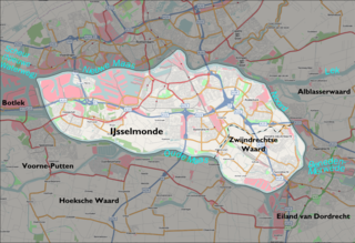
IJsselmonde is a river island in the Netherlands, between the Nieuwe Maas, Noord and Oude Maas branches rivers of the Rhine-Meuse delta in the province of South Holland. The city of Rotterdam now occupies most of the northern part of the island and includes the eponymous former village of IJsselmonde, once a separate community. The island was once a rich agricultural region, but is mostly suburbs today. Only the mid-south parts of the island have retained their agricultural character.

Dordrecht, historically known in English as Dordt or Dort, is a city and municipality in the Western Netherlands, located in the province of South Holland. It is the province's fifth-largest city after Rotterdam, The Hague, Zoetermeer and Leiden, with a population of 118,654. The municipality covers the entire Dordrecht Island, also often called Het Eiland van Dordt, bordered by the rivers Oude Maas, Beneden Merwede, Nieuwe Merwede, Hollands Diep, and Dordtsche Kil. Dordrecht is the largest and most important city in the Drechtsteden and is also part of the Randstad, the main conurbation in the Netherlands. Dordrecht is the oldest city in Holland and has a rich history and culture.

Moerdijk is a municipality and a town in the South of the Netherlands, in the province of North Brabant.

Sliedrechtlisten is a town and municipality in the western Netherlands, in the province of South Holland. The municipality covers an area of 14.01 km2 (5.41 sq mi) of which 1.17 km2 (0.45 sq mi) is covered by water.

Hollands Diep is a wide river in the Netherlands and an estuary of the Rhine and Meuse river. Through the Scheldt-Rhine Canal it connects to the Scheldt river and Antwerp.
The Nieuwe Merwede is a Dutch canal, mainly fed by the river Rhine, that was constructed in 1870 to form a branch in the Rhine-Meuse delta. It was dug along the general trajectories of a number of minor Biesbosch creeks to reduce the risk of flooding by diverting the water away from the Beneden Merwede, and to facilitate navigation and regulate river traffic in the increasingly silted-up delta.
The Hoekse Waard is an island between the Oude Maas, Dordtsche Kil, Hollands Diep, Haringvliet and Spui rivers in the province of South Holland in the Netherlands. The island, part of the namesake municipality of Hoeksche Waard, is a mostly agricultural region, south of the outskirts of Rotterdam. The Hoeksche Waard consists of reclaimed land (polders): after the Saint Elisabeth flood of 1421 most of the area was flooded. The land has been reclaimed gradually in the following centuries.

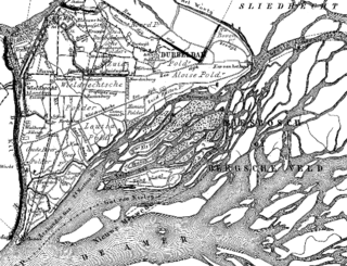
De Biesbosch National Park is one of the largest national parks of the Netherlands and one of the last extensive areas of freshwater tidal wetlands in Northwestern Europe. The Biesbosch consists of a large network of rivers and smaller and larger creeks with islands. The vegetation is mostly willow forests, although wet grasslands and fields of reed are common as well. The Biesbosch is an important wetland area for waterfowl and has a rich flora and fauna. It is especially important for migrating geese.
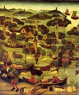
The St. Elizabeth's flood of 1421 was a flooding of the Grote Hollandse Waard, an area in what is now the Netherlands. It takes its name from the feast day of Saint Elisabeth of Hungary which was formerly November 19. It ranks 20th in the list of worst floods in history. During the night of November 18 to November 19, 1421, a heavy storm near the North Sea coast caused the dikes to break in a number of places and the lower lying polder land was flooded. A number of villages were swallowed by the flood and were lost, causing between 2,000 and 10,000 casualties. The dike breaks and floods caused widespread devastation in Zeeland and Holland.
Dirk VII was the count of Holland from 1190 to 1203. He was the elder son of Floris III and Ada of Huntingdon.

The Alblasserwaard is a polder in the province of South Holland, Netherlands. It is mainly known for the windmills of Kinderdijk, located near the village of Kinderdijk in the polder's northwestern part.
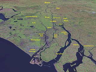
The Merwede is the name of several connected stretches of river in the Netherlands, between the cities of Woudrichem, Dordrecht and Papendrecht. The river is part of the Rhine–Meuse–Scheldt delta and is mostly fed by the river Rhine.

Maasdam is a village in the Dutch province of South Holland. It is located about 14 km south of the city of Rotterdam, in the municipality of Hoeksche Waard, on the rural Hoeksche Waard island.

The Oude Maas is a distributary of the Rhine River, and a former distributary of the Maas River, in the Dutch province of South Holland. It begins at the city of Dordrecht where the Beneden Merwede river splits into the Noord River and the Oude Maas. It ends when it joins the Nieuwe Maas to form Het Scheur.
The Waaltje is a dammed river in the western Netherlands, southeast of Rotterdam. Historically it used to be the western end of the Waal river, hence its official name continues to be Waal, although the intermediate Waal sections, Boven Merwede, Beneden Merwede, and a subsection of the Noord, have long changed their names.
