Wagenberg

Last updated • 1 min readFrom Wikipedia, The Free Encyclopedia
Wagenberg
Village
Sint-Gummaruskerk Wagenberg P1170224.jpg
St Gummarus Church
2010-NL-P10-Noord-Brabant-positiekaart-gemnamen.jpg
Red pog.svg
Wagenberg
Location in the province of North Brabant in the Netherlands
Netherlands location map.svg
Red pog.svg
Wagenberg
Wagenberg (Netherlands)
Coordinates: 51°39′50″N4°44′46″E / 51.6640°N 4.7461°E / 51.6640; 4.7461 Coordinates: 51°39′50″N4°44′46″E / 51.6640°N 4.7461°E / 51.6640; 4.7461
Country Netherlands
Province North Brabant
Municipality Drimmelen
Area
[1]
  Total5.36 km2 (2.07 sq mi)
Elevation
[2]
2.1 m (6.9 ft)
Population
 (2021) [1]
  Total2,180
  Density410/km2 (1,100/sq mi)
Time zone UTC+1 (CET)
  Summer (DST) UTC+2 (CEST)
Postal code
4844 [1]
Dialing code 076

Wagenberg is a village in the Dutch province of North Brabant. It is located in the municipality of Drimmelen. The village is located about 6 kilometres (3.7 mi) north of Breda. [3]

Contents

History

The village was first mentioned in 1331 as Wagenberghe, and means "hill of Wago (person)." [4] Wagenberg developed to the north of Terheijden in the Middle Ages. [5]

The Catholic St Gummarus Church is a three aisled basilica-like church in Gothic Revival style. It was built between 1903 and 1904 as a replacement of the 1796 church. It has a multi-coloured interior, and a 67 metres (220 ft) tall tower which is the same length as the church. In 1944, a bomb fell through the roof, but did not explode, and the damage could be repaired. [5] [6]

Wagenberg was home to 1,195 people in 1840. [7] The village was damaged by war in October and November 1944 resulting in 21 deaths among the population. The village used to be part of the municipality of Terheijden. In 1997, it became part of the Drimmelen. [7]

Notable people

Related Research Articles

<span class="mw-page-title-main">Baarle-Nassau</span> Municipality and town in North Brabant, Netherlands

Baarle-Nassau is a municipality and town in the southern Netherlands, located in the province of North Brabant. It had a population of 6,899 in 2019. The town is the site of a complicated borderline between Belgium and the Netherlands, with 22 small exclaves of the Belgian town Baarle-Hertog, some of which contain counter-exclaves of Nassau.

<span class="mw-page-title-main">Drimmelen</span> Municipality in North Brabant, Netherlands

Drimmelen is a municipality and a town in the southern Netherlands, in the province North Brabant.

<span class="mw-page-title-main">Breda</span> City and municipality in North Brabant, Netherlands

Breda is a city and municipality in the southern part of the Netherlands, located in the province of North Brabant. The name derived from brede Aa and refers to the confluence of the rivers Mark and Aa. Breda has 185,072 inhabitants on 13 September 2022 and is part of the Brabantse Stedenrij; it is the ninth largest city/municipality in the country, and the third largest in North Brabant after Eindhoven and Tilburg. It is equidistant between Rotterdam and Antwerp.

<span class="mw-page-title-main">Ellewoutsdijk</span> Village in Zeeland, Netherlands

Ellewoutsdijk is a village in the Dutch province of Zeeland. It is a part of the municipality of Borsele, and lies about 18 km east of Vlissingen.

<span class="mw-page-title-main">Chaam</span> Village in North Brabant, Netherlands

Chaam is a village in the Dutch province of North Brabant. It is located in the municipality of Alphen-Chaam, about 13 km southeast of Breda.

<span class="mw-page-title-main">Huijbergen</span> Village in North Brabant, Netherlands

Huijbergen is a village in the Dutch province of North Brabant. It is located in the municipality of Woensdrecht, about 9 kilometres (5.6 mi) southeast of Bergen op Zoom, close to the Belgian border.

<span class="mw-page-title-main">Made, Netherlands</span> Village in North Brabant, Netherlands

Made is a town in the Dutch province of North Brabant. It is located in the municipality of Drimmelen, about 10 km northeast of Breda.

<span class="mw-page-title-main">Terheijden</span> Village in North Brabant, Netherlands

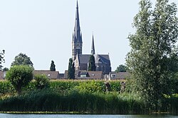
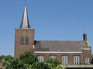
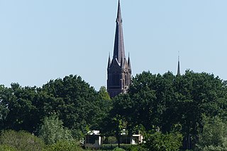
Terheijden is a village in the Dutch province of North Brabant. It is located in the municipality of Drimmelen, about 6 km north of Breda.

<span class="mw-page-title-main">Ulvenhout</span> Village in North Brabant, Netherlands

Ulvenhout is a village in the Dutch province of North Brabant. It is located in the municipality of Breda. The village was divided by the A58 motorway. The southern part belongs to the municipality of Alphen-Chaam and is called Ulvenhout AC.

<span class="mw-page-title-main">Michel van de Korput</span> Dutch association footballer

Michaël "Michel" Antonius Bernardus van de Korput is a retired Dutch footballer.

<span class="mw-page-title-main">De Arend, Terheijden</span> Windmill in The Netherlands

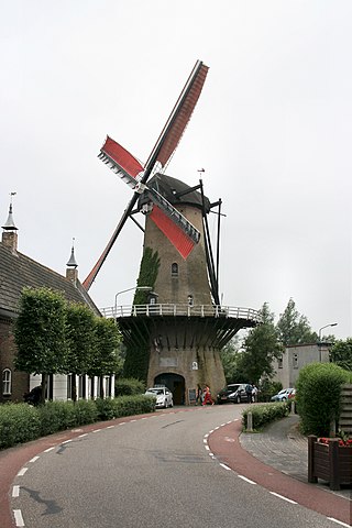
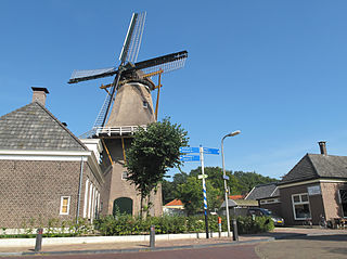
De Arend is a windmill located on the Molenstraat 40 in Terheijden, Drimmelen, in the province of North Brabant, Netherlands. Built in 1742 the windmill functioned as a gristmill. The mill was built as a tower mill and its sails have a span of 24.80 meters. The mill is a national monument since 19 May 1971. The mill is still in use and is property of the municipality of Drimmelen. It is open to public viewing.

<span class="mw-page-title-main">Langenboom</span> Village in North Brabant, Netherlands

Langenboom is a village in the Dutch province of North Brabant. It is part of the municipality of Land van Cuijk. Langenboom is located in the Peel region, and lies about 18 kilometres (11 mi) south-west of Nijmegen.

<span class="mw-page-title-main">Middelbeers</span> Village in North Brabant, Netherlands

Middelbeers is a village in the municipality of Oirschot in the Dutch province of North Brabant. It is located between Oirschot and Hilvarenbeek. It is one of the three Beers villages.

<span class="mw-page-title-main">Hooge Zwaluwe</span> Village in North Brabant, Netherlands

Hooge Zwaluwe is a village in the Dutch province of North Brabant. It is located in the municipality of Drimmelen, about 3.5 km north-west of Made.

<span class="mw-page-title-main">Den Andel</span> Village in Groningen, Netherlands

Den Andel is a village in the municipality Het Hogeland which is part of the province Groningen in the Netherlands. It is located about 20 kilometres (12 mi) north of the city of Groningen near the Wadden Sea coast.

<span class="mw-page-title-main">Drempt</span> Village in Gelderland, Netherlands

Drempt is a village in the Dutch province of Gelderland. It is located in the municipality of Bronckhorst. It used to consists of two villages: Achter-Drempt (behind) and Voor-Drempt which have merged. Drempt is located about 9 kilometres (5.6 mi) north-west of Doetinchem.

<span class="mw-page-title-main">Soerendonk</span> Village in North Brabant, Netherlands

Soerendonk is a village in the Dutch province of North Brabant. It is located in the municipality of Cranendonck. The former Cranendonck Castle used to be located in the village. It is located about 17 kilometres (11 mi) south-south-east of Eindhoven.

<span class="mw-page-title-main">Hoonhorst</span> Village in Overijssel, Netherlands

Hoonhorst is a village in the municipality of Dalfsen in the province of Overijssel, Netherlands. It is a Catholic enclave in a Protestant area. It located about 9 kilometres (5.6 mi) east of Zwolle.

<span class="mw-page-title-main">Tienray</span> Village in Limburg, Netherlands

Tienray is a village in the Dutch province of Limburg. It is a part of the municipality of Horst aan de Maas, and is located about 15 kilometres (9.3 mi) north of Venlo.

<span class="mw-page-title-main">Beugen</span> Village in North Brabant, Netherlands

Beugen is a village in the Dutch province of North Brabant. It is part of the municipality of Land van Cuijk. Beugen is located along the Maas and about 20 kilometres (12 mi) south of Nijmegen.

References

  1. 1 2 3 "Kerncijfers wijken en buurten 2021". Central Bureau of Statistics. Retrieved 28 April 2022.
  2. "Postcodetool for 4844AA". Actueel Hoogtebestand Nederland (in Dutch). Het Waterschapshuis. Retrieved 28 April 2022.
  3. "Distance Wagenberg, NLD -> Breda, NLD". Distance.to (in Dutch). Retrieved 28 April 2022.
  4. "Wagenberg - (geografische naam)". Etymologiebank (in Dutch). Retrieved 28 April 2022.
  5. 1 2 Chris Kolman & Ronald Stenvert (1997). Terheijden (in Dutch). Zwolle: Waanders. p. 302. ISBN   90 400 9945 6 . Retrieved 28 April 2022.
  6. "H. Gummaruskerk Wagenberg". Naar de kerk (in Dutch). Retrieved 28 April 2022.
  7. 1 2 "Wagenberg". Plaatsengids (in Dutch). Retrieved 28 April 2022.
  8. "Michael van de Korput". World Football (in Dutch). Retrieved 28 April 2022.