Moerdijk bridges

Last updated
Moerdijk bridges in 2001 Moerdijkbrug overzicht.jpeg
Moerdijk bridges in 2001

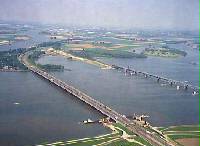
The Moerdijk bridges in the Netherlands are bridges that connect the Island of Dordrecht with the Dutch province of North Brabant (Noord-Brabant) across the Hollands Diep . The first bridge was built at the end of the 19th century, and was a railway bridge. The second bridge was built in the 1930s for road traffic, and is currently part of the A16 motorway. This bridge was replaced in 1978 by a more modern, wider bridge. A second railroad bridge was finished in 2006, as part of the HSL-Zuid project.

At the beginning of the Battle of Holland, on 10 May 1940, bridges were captured during a paratroopers operation and held for 4 days until German forward forces arrived. In 1944, both the road and railway bridge were destroyed by the Germans to prevent the Allied Forces from reaching the province South Holland.

Coordinates: 51°43′N4°38′E / 51.72°N 4.64°E / 51.72; 4.64


Related Research Articles

<span class="mw-page-title-main">Overijssel</span> Province of the Netherlands

Overijssel is a province of the Netherlands located in the eastern part of the country. The province's name translates to "across the IJssel", from the perspective of the Episcopal principality of Utrecht by which it was held until 1528. The capital city of Overijssel is Zwolle and the largest city is Enschede. The province had a population of 1,162,215 as of November 2019. The land mostly consists of grasslands and some forests ; it also borders a small part of the IJsselmeer to the west.

<span class="mw-page-title-main">Walcheren</span> Former Island in Zeeland, Netherlands

Walcheren is a region and former island in the Dutch province of Zeeland at the mouth of the Scheldt estuary. It lies between the Eastern Scheldt in the north and the Western Scheldt in the south and is roughly the shape of a rhombus. The two sides facing the North Sea consist of dunes and the rest of its coastline is made up of dykes. Middelburg, the provincial capital, lies at Walcheren's centre. Vlissingen, 9 kilometres (5.6 mi) to the south, is the main harbour and the third municipality is Veere.

<span class="mw-page-title-main">Mook en Middelaar</span> Municipality in Limburg, Netherlands

Mook en Middelaar is a municipality in the upper southeastern part of the Netherlands, at the northern tip of the province of Limburg and is a part of Stadsregio Arnhem Nijmegen. The municipality is located about 100 km from provincial capital Maastricht and has an area of 18.81 km2 (7.26 sq mi) of which 1.43 km2 (0.55 sq mi) is water.

<span class="mw-page-title-main">Heusden</span> Municipality in North Brabant, Netherlands

Heusden is a municipality and a town in the South of the Netherlands. It is located between the towns of Waalwijk and 's-Hertogenbosch. The municipality of Heusden, including Herpt, Heesbeen, Hedikhuizen, Doeveren, and Oudheusden, merged with Drunen and Vlijmen in 1997, giving the municipality its current form.

<span class="mw-page-title-main">Bergse Maas</span>

The Bergse Maas is a canal that was constructed in 1904 to be a branch of the river Maas in the Dutch province of North Brabant. The Maas splits near Heusden into the Afgedamde Maas and the Bergse Maas. The Afgedamde Maas flows north until its confluence with the river Waal to form the Merwede, while the Bergse Maas continues west as the main distributary of the Maas. Part of the Merwede rejoins the Bergse Maas to form the Hollands Diep estuary.

<span class="mw-page-title-main">Scheldt–Rhine Canal</span> Canal connecting Belgium and Netherlands

The Scheldt–Rhine Canal (Schelde-Rijnkanaal) in Belgium and the Netherlands connects Antwerp with the Volkerak, and thereby the Scheldt with the Rhine.

<span class="mw-page-title-main">Bridge to nowhere</span> Type of unfinished bridge

A bridge to nowhere is a bridge where one or both ends are broken, incomplete, or unconnected to any roads. If it is an overpass or an interchange, the term overpass to nowhere or interchange to nowhere may be used respectively. There are five main origins for these bridges:

<span class="mw-page-title-main">Hoeksche Waard</span> Island in South Holland, Netherlands

The Hoekse Waard is an island between the Oude Maas, Dordtsche Kil, Hollands Diep, Haringvliet and Spui rivers in the province of South Holland in the Netherlands. The island, part of the namesake municipality of Hoeksche Waard, is a mostly agricultural region, south of the outskirts of Rotterdam. The Hoeksche Waard consists of reclaimed land (polders): after the Saint Elisabeth flood of 1421 most of the area was flooded. The land has been reclaimed gradually in the following centuries.

<span class="mw-page-title-main">Fall of Antwerp</span> 1585 end of siege by Spanish forces against a Dutch garrison in Eighty Years War

The fall of Antwerp on 17 August 1585 took place during the Eighty Years' War, after a siege lasting over a year from July 1584 until August 1585. The city of Antwerp was the focal point of the Protestant-dominated Dutch Revolt, but was forced to surrender to the Spanish forces. Under the terms agreed, all Protestants were given four years to settle their affairs and leave the city. Many migrated north, especially to Amsterdam, which became the capital of the Dutch Republic. Apart from losing a high proportion of its mercantile population, Antwerp's trade suffered for two centuries as Dutch forts blockaded the River Scheldt up to 1795.

<span class="mw-page-title-main">Bennekom</span> Village in Gelderland, Netherlands

Bennekom is a village and parish in the Netherlands, which is part of the Municipality of Ede in the south-west of the Veluwe district of the Province of Gelderland. It adjoins the town of Wageningen on the Lower-Rhine to the south, and Ede to the north, Veenendaal to the west and Renkum to the east. The western boundary of the parish follows the canalized River Grift and is also the boundary with the Province of Utrecht.

<span class="mw-page-title-main">German invasion of the Netherlands</span> 1940 German invasion during World War II

The German invasion of the Netherlands, otherwise known as the Battle of the Netherlands, was a military campaign part of Case Yellow, the Nazi German invasion of the Low Countries and France during World War II. The battle lasted from 10 May 1940 until the surrender of the main Dutch forces on 14 May. Dutch troops in the province of Zeeland continued to resist the Wehrmacht until 17 May when Germany completed its occupation of the whole country.

<span class="mw-page-title-main">Roßlau</span> Stadtteil of Dessau-Roßlau in Saxony-Anhalt, Germany

Rosslau was until 30 June 2007 a town in Saxony-Anhalt, Germany, belonging to the district Anhalt-Zerbst. After a fusion with the town of Dessau it became eponym of the newly founded town of Dessau-Roßlau and a quarter of it. Rosslau is situated on the right bank of the Elbe, here crossed by two railway bridges, 3 mi. by rail N. of Dessau and 35 mi. S.E. of Magdeburg. It has a ducal residence, an old castle, a handsome parish church, and manufactures of machinery, paper, sealing-wax, wire goods, sugar, bricks and chemicals. Rosslau became a town in 1603.

<span class="mw-page-title-main">A50 motorway (Netherlands)</span> Motorway in the Netherlands

A50, the section of Rijksweg 50 that is constructed as controlled-access highway, is a north–south motorway in the Netherlands, running from Eindhoven in the province of North Brabant, northwards passing by the cities of Oss, Nijmegen, Arnhem and Apeldoorn, to its northern terminus in the province of Gelderland near the city of Zwolle.

<span class="mw-page-title-main">Zandoerle</span> Hamlet in North Brabant, Netherlands

Zandoerle, in local tongue known as Zandoers, is a hamlet in the municipality of Veldhoven in the province of North Brabant, the Netherlands. The hamlet has a population of 120 people, as measured on the first of January 2008. The hamlet is located between the villages Oerle and Knegsel. Zandoerle can be seen as one of the two centres within the village of Oerle. The other centre is often referred to as Kerkoerle . Zandoerle has great cultural and historical value due to its characteristic village green and monumental farms.

<span class="mw-page-title-main">Oude Maas</span> Distributary of the Rhine River in South Holland, Netherlands

The Oude Maas is a distributary of the river Rhine, and a former distributary of the river Maas, in the Dutch province of South Holland. It begins at the city of Dordrecht where the Beneden Merwede river splits into the Noord and the Oude Maas. It ends when it joins the Nieuwe Maas to form Het Scheur.

<span class="mw-page-title-main">Maas–Waal Canal</span>

The Maas–Waal Canal is a canal in the Netherlands that connects the river Meuse to the river Waal. The channel is about 13.5 kilometres (8.4 mi) long and runs from Weurt to the south and ends at Heumen. The connection of the Meuse and the Maas–Waal Canal is the tripoint between the provinces of Gelderland, Limburg and North Brabant.

<span class="mw-page-title-main">Operation Pheasant</span> WWII Allied action liberating North Brabant, Netherlands

Operation Pheasant, also known as the Liberation of North Brabant, was a major operation to clear German troops from the province of North Brabant in the Netherlands during the fighting on the Western Front in the Second World War. This offensive was conceived as a result of the failure of Operation Market Garden and the allied effort to capture the important port of Antwerp. It was conducted by the allied 21st Army Group between 20 October to 4 November 1944.

<span class="mw-page-title-main">Noord-Brabantsch-Duitsche Spoorweg-Maatschappij</span> Railway company in the Netherlands (1873–1925)

The Noord-Brabantsch-Deutsche Spoorweg-Maatschappij (NBDS) was a railway company undertaking and providing rail transport between Boxtel and Wesel via Uden, Veghel, Gennep, Goch and Xanten. This railway was known in the Netherlands as "Duits lijntje ". On July 15, 1873, the section from Boxtel to Goch could be opened. On July 1, 1878, the second section of the line, the section from Goch to Wesel, could be opened. The total length of the line was 92.7 kilometers, of which 52.7 kilometers on Dutch territory. From Büderich, another 8.2 kilometers of the Köln-Mindener Eisenbahn was used, so was a part of the line from Venlo via Wesel to Haltern, Münster and Hamburg.

<span class="mw-page-title-main">Cuijk</span> Town in North Brabant, Netherlands

Cuijk is a town in the northeastern part of the province of North Brabant, Netherlands. It is the successor of a Roman settlement on the west bank of the Meuse, 13 km (8 mi) south of Nijmegen. Cuijk, which had a population of 18,170 as of 2020, was the centre of an eponymous municipality, which ceased to exist on 1 January 2022, when it was replaced by the larger Land van Cuijk municipality.