
Ventura County is a county in the southern part of the U.S. state of California. As of the 2010 census, the population was 823,318. The largest city is Oxnard, and the county seat is the city of Ventura.

Thousand Oaks is the second-largest city in Ventura County, California, United States. It is in the northwestern part of Greater Los Angeles, approximately 40 miles (64 km) from Downtown Los Angeles, and is less than 15 miles (24 km) from the Los Angeles neighborhood of Woodland Hills. It is named after the many oak trees present in the area.

Westlake Village is a city in Los Angeles County on its western border with Ventura County. The City of Westlake Village incorporated in 1981 becoming the 82nd municipality of Los Angeles County. The population of the city was estimated to be at 8,217 in 2019, down from 8,270 at the 2010 census.

The Conejo Valley is a region spanning both southeastern Ventura County and northwestern Los Angeles County in Southern California, United States. It is located in the northwestern part of the Greater Los Angeles Area.

Newbury Park is a populated place and town in Ventura County, California, United States. Most of it lies within the western Thousand Oaks city limits while other parts of Newbury Park such as Casa Conejo and Ventu Park remain in unincorporated areas. It makes up all of ZIP code 91320, and is within area code 805. Lying within the Conejo Valley in the northwestern part of the Greater Los Angeles Area, Newbury Park abuts the Santa Monica Mountains. It is approximately 35 miles (56 km) from Downtown Los Angeles and less than 7 mi (11 km) from the Los Angeles County border in Westlake Village. The closest coastal city is Malibu, 22 mi (35 km) from Newbury Park, which may be reached through winding roads or hiking trails crossing the Santa Monica Mountains. About 28,000 residents of Thousand Oaks reside in Newbury Park. Newbury Park makes up around 40 percent of Thousand Oaks' total land area.

The Stagecoach Inn Museum in Newbury Park, California, originally known as the Grand Union Hotel, was used as a resting area for people who traveled from Los Angeles to Santa Barbara. Besides a hotel and stagecoach stop, it has also been used as a post office, church, restaurant and military school. It is California Historical Landmark No. 659 and is listed in the National Register of Historic Places. It played a major role in the development of the stage line transportation network in California. The hotel was also the first business venture in the Conejo Valley.
Rancho El Conejo was a 48,572-acre (196.56 km2) Spanish land grant in California given in 1803 to Jose Polanco and Ygnacio Rodriguez that encompassed the area now known as the Conejo Valley in southeastern Ventura and northwestern Los Angeles Counties. El Conejo means "The Rabbit" in Spanish, and refers to the many rabbits common to the region. The east-west grant boundaries approximately went from the border of Westlake Village near Lindero Canyon Road in the east to the Conejo Grade in the west. The north-south borders extended from the top of the Simi Hills at the end of Moorpark Road in the north to Hidden Valley in the Santa Monica Mountains in the south. The rancho is the site of the communities of Newbury Park, Thousand Oaks, and Westlake Village.

The Conejo Grade, also known as the Camarillo Grade, is a 7% grade incline with a summit elevation of 841.1 feet (256.4 m). It is a section of US 101 linking Thousand Oaks and cities of the Conejo Valley, with Camarillo and the cities on the Oxnard Plain. A Caltrans inspection station for trucks is stationed at the upper terminus of the grade.

Rancho Sierra Vista is one of the last intact ranches from the first half of the twentieth century in the Santa Monica Mountains. The majority of the landscape is much as it was 100 years ago. The area is now owned by the Santa Monica Mountains National Recreation Area, a unit of the National Park System.

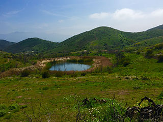
The Conejo Canyons Open Space consists of 1,628 acres (659 ha) of open-space areas in northernmost Newbury Park, Ventura County, California. It consists of deeply eroded canyons, numerous ridgelines and plateaus in the northwestern portion of the Conejo Valley. The area consists of diverse natural features such as deep canyons with perennial streams, prominent ridgelines, volcanic mountains, and a variety of natural habitats. While some of the flora includes chaparral, riparian habitats, oak woodlands and coastal sage, fauna includes mountain lions, coyotes, mule deer, and bobcats.

Cypress Park is a five-acre neighborhood park in southwestern Newbury Park, California. Acquired in 1969, the land was developed into a community park in 1973 with a baseball field, a playground, picnic tables, and bleachers. It is owned and operated by the Conejo Recreation & Park District (CRPD). Situated immediately south of Cypress Elementary School, the park is also home to several ponds and smaller creeks. It is used for bird-observations, recreational activities, picnicking, and camping.

Dos Vientos Community Park in southwestern Newbury Park, CA is the largest of Conejo Recreation & Park District’s public parks in the Conejo Valley. It is adjacent to the Dos Vientos Community Center, which offers a preschool, sports, and other activities. The park contains sand volleyball courts, baseball-, basketball- and tennis courts, soccer fields, playground areas, and picnic tables and barbecue grills. It is adjacent to the Dos Vientos Open Space through the Park View Trail, which is a 1,216 acre natural open-space, bordering an additional 16,000 acres of open space stretching over the Santa Monica Mountains National Recreation Area to the Pacific Ocean. The Park View Trail ends at Via Ricardo, directly across the road from the Powerline Trail and Dos Vientos Open Space.

Conejo Mountain is a 1,814-foot-high mountain (553 m) in Ventura County, California near Camarillo on the eastern boundary of the Oxnard Plain. At the western edge of the Conejo Valley, it is adjacent to the Santa Monica Mountains. Crossing what was once a formidable barrier for travelers, U.S. Route 101 passes through the area on the steep Conejo Grade.
Dos Vientos Open Space is a 1,216 acres (492 ha) open space area in western Newbury Park, California. It contains more than 41 miles (66 km) of trails used for cycling, hiking and equestrians. Originally a part of the Rancho Guadalasca Spanish Land Grant of 1836, the area is now an important wildlife movement corridor into the Santa Monica Mountains through the Point Mugu State Park. It provides a habitat for a variety of wildlife, including bobcats, mule deer, coyotes, eagles, hawks, barn owls, mountain lions, and more. It provides regional and internal trail connections, many trails offering panoramic views of the Conejo Valley, Oxnard Plain, Topatopa Mountains, Channel Islands, and the Pacific Ocean. Some of the endangered plant species found here include Conejo buckwheat, Verity's liveforever, and Conejo dudleya. The landscape is undeveloped, and dominated by coastal sage scrub, grassy hillsides, oak woodlands, and chaparral habitats.

Ventu Park Open Space is a 141-acre open space area in Newbury Park, California. Its primary features are the Rosewood Trail leading to Angel Vista, a 1,603 ft peak in the Santa Monica Mountains. Parking for the Rosewood Trail is located at the Stagecoach Inn Park, across Lynn Road from the primary trailhead. The Rosewood Trail begins with oak woodland and crosses a creek at the canyon floor, before climbing up towards the steep Angel Vista Point. There are 360-degree panoramic views of the Conejo Valley, the Oxnard Plain, the California Channel Islands, Pacific Ocean, Point Mugu, Hidden Valley, as well as the Santa Monica-, Santa Susana- and Topa Topa Mountains.
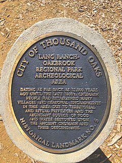
Chumash Indian Museum is a Native American Interpretive Center in northeast Thousand Oaks, California. It is the site of a former Chumash village, known as Sap'wi. It is located in Oakbrook Regional Park, a 432-acre park which is home to a replica of a Chumash village and thousand year-old Chumash pictographs. The pictographs by nearby Birthing Cave are not open to the public, but can be observed on docent-led tours. Chumash people inhabited the village 10,000 years ago.
Reba Marie Hays Jeffries was one of the founders of Newbury Park Chamber of Commerce and later its first female president. She was a prominent supporter of Newbury Park cityhood and opposed the annexation by neighboring Thousand Oaks. She was also an outspoken supporter of preserving Stagecoach Inn and the Newbury Park Post Office when it was proposed that they be demolished.

Conejo Recreation and Park District (CRPD) is the park management agency for most of the parks in the Conejo Valley, California. Established in 1962, CRPD later established Conejo Open Space Conservation Agency (COSCA) in 1977 through a joint effort with the City of Thousand Oaks. COSCA administers over 15,000 acres of open space and 140 miles of trails, while CRPD administers over 50 community parks. CRPD's annual operating budget is $20,000,000, of which about 70% are from property taxes.

Timber School was the first school in Newbury Park, California when established in 1889. and the current 1924 reconstructed Timber School is the oldest remaining school in the City of Thousand Oaks. It is also the oldest remaining public building in the Conejo Valley.

Pederson House and Water Tower is located at the campus of California Lutheran University (CLU) in Thousand Oaks, California, the former home of the Norwegian Colony. It was built by members of the Colony that settled here in 1890. The structure is designated Ventura County Historic Landmark No. 45 and Thousand Oaks Historical Landmark No. 3. It is a typical turn-of-the-century farmhouse constructed in 1913-14 for Lars and Karn Pederson, Norwegian immigrants and members of the Norwegian Colony, who had first settled in Conejo Valley in 1890. The house was erected at the present location of Ahmanson Science Center, but was later relocated 500 feet (150 m) to its current location at the corner of Regent Avenue and Faculty Street. When its original location was determined to become a science building, the university was quoted $125,000 in moving costs, and therefore planned to demolish the house. However, CLU alumni were able to raise the amount in one day and were successful in saving the house.
