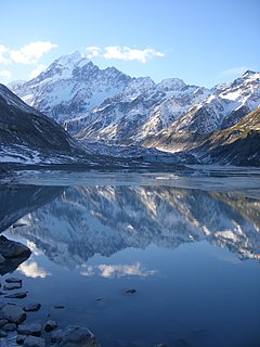
Aoraki / Mount Cook is the highest mountain in New Zealand. Its height since 2014 is listed as 3,724 metres, down from 3,764 m (12,349 ft) before December 1991, due to a rockslide and subsequent erosion. It lies in the Southern Alps, the mountain range which runs the length of the South Island. A popular tourist destination, it is also a favourite challenge for mountain climbers. Aoraki / Mount Cook consists of three summits, from South to North the Low Peak, Middle Peak and High Peak. The summits lie slightly south and east of the main divide of the Southern Alps, with the Tasman Glacier to the east and the Hooker Glacier to the southwest.
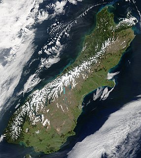
The Southern Alps / Kā Tiritiri o te Moana is a mountain range extending along much of the length of New Zealand's South Island, reaching its greatest elevations near the range's western side. The name "Southern Alps" generally refers to the entire range, although separate names are given to many of the smaller ranges that form part of it.

Mount Erebus is the second-highest volcano in Antarctica and the southernmost active volcano on Earth. It is the sixth-highest ultra mountain on the continent. With a summit elevation of 3,794 metres (12,448 ft), it is located in the Ross Dependency on Ross Island, which is also home to three inactive volcanoes: Mount Terror, Mount Bird, and Mount Terra Nova.

The Alaska Range is a relatively narrow, 650-km-long (400 mi) mountain range in the southcentral region of the U.S. state of Alaska, from Lake Clark at its southwest end to the White River in Canada's Yukon Territory in the southeast. The highest mountain in North America, Denali, is in the Alaska Range. It is part of the American Cordillera.

Aoraki/Mount Cook National Park is in the South Island of New Zealand, near the town of Twizel. Aoraki / Mount Cook, New Zealand's highest mountain, and Aoraki/Mount Cook Village lie within the park. The area was gazetted as a national park in October 1953 and consists of reserves that were established as early as 1887 to protect the area's significant vegetation and landscape.

Mount Tongariro is a compound volcano in the Taupo Volcanic Zone of the North Island of New Zealand. It is located 20 kilometres (12 mi) to the southwest of Lake Taupo, and is the northernmost of the three active volcanoes that dominate the landscape of the central North Island.

The Godley River is an alpine braided river flowing through Canterbury, in New Zealand's South Island.

The Mueller Glacier is a 13-kilometre (8.1 mi) long glacier flowing through Aoraki/Mount Cook National Park in the South Island of New Zealand. It lies to the south of Aoraki/Mount Cook, high in the Southern Alps, and flows north. Its meltwaters eventually join the Tasman River.

The Murchison River lies within the Aoraki/Mount Cook National Park in the South Island of New Zealand.

The Usarp Mountains is a major Antarctic mountain range, lying westward of the Rennick Glacier and trending N-S for about 190 kilometres (118 mi). The feature is bounded to the north by Pryor Glacier and the Wilson Hills. Its important constituent parts include Welcome Mountain, Mount Van der Hoeven, Mount Weihaupt, Mount Stuart, Mount Lorius, Smith Bench, Mount Roberts, Pomerantz Tableland, Daniels Range, Emlen Peaks, Helliwell Hills and Morozumi Range.

Mackenzie District is a local government district in New Zealand's South Island administered by the Mackenzie District Council. It is part of the larger Canterbury region.
Martin Glacier is a glacier, 3 nautical miles (6 km) wide and 9 nautical miles (17 km) long, which flows west and then northwest from the south side of Mount Lupa to the southeast corner of Rymill Bay where it joins Bertrand Ice Piedmont, on the west coast of Graham Land, Antarctica. It was first surveyed in 1936 by the British Graham Land Expedition (BGLE) under John Riddoch Rymill, and was resurveyed in 1948–1949 by the Falkland Islands Dependencies Survey. The glacier was named for James H. Martin, a member of the British Australian and New Zealand Antarctic Research Expedition (1929–1931) under Sir Douglas Mawson, and first mate of the Penola during the BGLE.

Borchgrevink Glacier is a large glacier in the Victory Mountains, Victoria Land, draining south between Malta Plateau and Daniell Peninsula, and thence projecting into Glacier Strait, Ross Sea, as a floating glacier tongue, the Borchgrevink Glacier Tongue, just south of Cape Jones. It was named by the New Zealand Geological Survey Antarctic Expedition, 1957–58, for Carsten Borchgrevink, leader of the British Antarctic Expedition, 1898–1900. Borchgrevink visited the area in February 1900 and first observed the seaward portion of the glacier.

Glacier Peak Wilderness is a 566,057-acre (229,075 ha), 35-mile-long (56 km), 20-mile-wide (32 km) wilderness area located within portions of Chelan, Snohomish, and Skagit counties in the North Cascades of Washington. The area lies within parts of Wenatchee National Forest and Mount Baker National Forest and is characterized by heavily forested stream courses, steep-sided valleys, and dramatic glacier-crowned peaks. The dominant geologic feature of the area is 10,541-foot (3,213 m) Glacier Peak. It is the most remote major volcanic peak in the Cascade Range and has more active glaciers than any other place in the lower forty-eight states. Glacier Peak is a volcanic cone of basalt, pumice, and ash which erupted during periods of heavy glaciation.

Mount Crillon is a high peak of the Fairweather Range, the southernmost part of the Saint Elias Mountains. It lies southeast of Mount Fairweather, in the promontory between the Gulf of Alaska and Glacier Bay. It is included in Glacier Bay National Park. The peak was named after Felix-Francois-Dorothee de Bretton, Comte de Crillon, by his friend, the French explorer Jean Francois de Galaup de la Perouse.
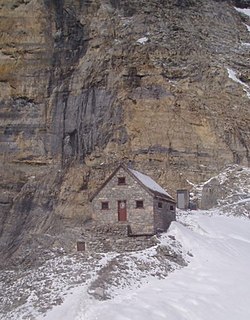
The Abbot Pass hut is an alpine hut located at an altitude of 2925 metres in Abbot Pass in the Rocky Mountains in Alberta, Canada. It is nestled between Mount Victoria and Mount Lefroy, straddling the continental divide, which, in this region, defines the boundary between Banff National Park in Alberta and Yoho National Park in British Columbia. While close to the border, the hut lies entirely in Banff National Park, and is the second-highest permanently habitable structure in Canada. The hut is maintained by the Alpine Club of Canada.
Le Couteur Glacier is a glacier, 15 nautical miles (28 km) long, which drains the northwest slopes of Mount Hall and Mount Daniel and flows north along the west side of the Lillie Range to the Ross Ice Shelf, Antarctica. It was named by the Southern Party of the New Zealand Geological Survey Antarctic Expedition (1963–64) for P. C. Le Couteur, a geologist with the New Zealand Federated Mountain Clubs Antarctic Expedition, 1962–63.
Canyon Glacier is a narrow glacier, 35 nautical miles (65 km) long, flowing to the Ross Ice Shelf. It drains the northwest slopes of Mount Wexler and moves northward between steep canyon walls of the Separation Range and Hughes Range to join the ice shelf immediately west of Giovinco Ice Piedmont. The glacier was observed from nearby Mount Patrick by the New Zealand Alpine Club Antarctic Expedition (1959–60) who gave the descriptive name.

Charles (Charlie) Edward Douglas came to be known as Mr. Explorer Douglas owing to his extensive explorations of the West Coast Region of New Zealand and his work for the New Zealand Survey Department. Charlie Douglas was awarded the Royal Geographical Society Gill Memorial Prize in 1897.

The Hooker Valley Track is the most popular short walking track within the Aoraki/Mount Cook National Park in New Zealand. At only 5 kilometres (3.1 mi) length and gaining only about 100 m (330 ft) in height, the well formed track can be walked by tourists with a wide range of level of fitness.


