Related Research Articles
The Amazon River in South America is the largest river by discharge volume of water in the world, and the disputed longest river system in the world in comparison to the Nile.

Brazil, officially the Federative Republic of Brazil, is the largest country in South America and in Latin America. At 8.5 million square kilometers (3,300,000 sq mi) and with over 217 million people, Brazil is the world's fifth-largest country by area and the seventh most populous. Its capital is Brasília, and its most populous city is São Paulo. The federation is composed of the union of the 26 states and the Federal District. It is the only country in the Americas to have Portuguese as an official language. It is one of the most multicultural and ethnically diverse nations, due to over a century of mass immigration from around the world, and the most populous Roman Catholic-majority country.

The country of Brazil occupies roughly half of South America, bordering the Atlantic Ocean. Brazil covers a total area of 8,514,215 km2 (3,287,357 sq mi) which includes 8,456,510 km2 (3,265,080 sq mi) of land and 55,455 km2 (21,411 sq mi) of water. The highest point in Brazil is Pico da Neblina at 2,994 m (9,823 ft). Brazil is bordered by the countries of Argentina, Bolivia, Colombia, Guyana, Paraguay, Peru, Suriname, Uruguay, Venezuela, and France.

South America is a continent entirely in the Western Hemisphere and mostly in the Southern Hemisphere, with a relatively small portion in the Northern Hemisphere at the northern tip of the continent. It can also be described as the southern subregion of a single continent called America.

The Americas, which are sometimes collectively called America, are a landmass comprising the totality of North and South America. The Americas make up most of the land in Earth's Western Hemisphere and comprise the New World.

Iguazú Falls or Iguaçu Falls are waterfalls of the Iguazu River on the border of the Argentine province of Misiones and the Brazilian state of Paraná. Together, they make up the largest waterfall system in the world. The falls divide the river into the upper and lower Iguazu. The Iguazu River rises near the heart of the city of Curitiba. For most of its course, the river flows through Brazil; however, most of the falls are on the Argentine side. Below its confluence with the San Antonio River, the Iguazu River forms the border between Argentina and Brazil.

The Amazon river dolphin, also known as the boto, bufeo or pink river dolphin, is a species of toothed whale classified in the family Iniidae. Three subspecies are currently recognized: I. g. geoffrensis, I. g. boliviensis and I. g. humboldtiana while position of Araguaian river dolphin within the clade is still unclear. The three subspecies are distributed in the Amazon basin, the upper Madeira River in Bolivia, and the Orinoco basin, respectively.

Maranhão is a state in Brazil. Located in the country's Northeast Region, it has a population of about 7 million and an area of 332,000 km2 (128,000 sq mi). Clockwise from north, it borders on the Atlantic Ocean for 2,243 km and the states of Piauí, Tocantins and Pará. The people of Maranhão have a distinctive accent inside the common Northeastern Brazilian dialect. Maranhão is described in books such as The Land of the Palm Trees by Gonçalves Dias and Casa de Pensão by Aluísio Azevedo.
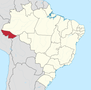
Acre is a state located in the west of the North Region of Brazil and the Amazonia Legal. Located in the westernmost part of the country, at a two-hour time difference from Brasília, Acre is bordered clockwise by the Brazilian states of Amazonas and Rondônia to the north and east, the Bolivian department of Pando to the southeast, and the Peruvian regions of Madre de Dios, Ucayali and Loreto to the south and west. The state, which has 0.42% of the Brazilian population, generates 0.2% of the Brazilian GDP.

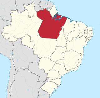
Amazonas is a state of Brazil, located in the North Region in the northwestern corner of the country. It is the largest Brazilian state by area and the 9th largest country subdivision in the world, and the largest in South America, being greater than the areas of Uruguay, Paraguay, and Chile combined. Mostly located in the Southern Hemisphere, it is the third largest country subdivision in the Southern Hemisphere after the Australian states of Western Australia and Queensland. Entirely in the Western Hemisphere, it is the fourth largest in the Western Hemisphere after Greenland, Nunavut and Alaska. It would be the sixteenth largest country in land area, slightly larger than Mongolia. Neighbouring states are Roraima, Pará, Mato Grosso, Rondônia, and Acre. It also borders the nations of Peru, Colombia and Venezuela. This includes the Departments of Amazonas, Vaupés and Guainía in Colombia, as well as the Amazonas state in Venezuela, and the Loreto Region in Peru.
Pará is a state of Brazil, located in northern Brazil and traversed by the lower Amazon River. It borders the Brazilian states of Amapá, Maranhão, Tocantins, Mato Grosso, Amazonas and Roraima. To the northwest are the borders of Guyana and Suriname, to the northeast of Pará is the Atlantic Ocean. The capital and largest city is Belém, which is located at the Marajó bay, near the estuary of the Amazon river. The state, which is home to 4.1% of the Brazilian population, is responsible for just 2.2% of the Brazilian GDP.

Sergipe, officially State of Sergipe, is a state of Brazil. Located in the Northeast Region along the Atlantic coast of the country, Sergipe is the smallest state in Brazil by geographical area at 21,910 square kilometres (8,460 sq mi), larger only than the Federal District. Sergipe borders Bahia to the south and west and Alagoas to the north. Aracaju is the capital and the largest city in the state; the state is divided into 75 municipalities. The state has 1.1% of the Brazilian population and produces only 0.6% of the Brazilian GDP.
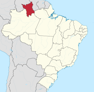
Roraima is one of the 26 states of Brazil. Located in the country's North Region, it is the northernmost and most geographically and logistically isolated state in Brazil. It is bordered by the state of Pará to the southeast, Amazonas to the south and west, Venezuela to the north and northwest, and Guyana to the east.

São Paulo is the most populous city in Brazil, and is the capital of the state of São Paulo, the most populous and wealthiest Brazilian state, located in the country's Southeast Region. Listed by the GaWC as an alpha global city, São Paulo is the most populous city proper in the Americas, the Western Hemisphere and the Southern Hemisphere, as well as the world's 4th largest city proper by population. Additionally, São Paulo is the largest Portuguese-speaking city in the world. It exerts strong international influences in commerce, finance, arts and entertainment. The city's name honors the Apostle, Saint Paul of Tarsus. The city's metropolitan area, the Greater São Paulo, ranks as the most populous in Brazil and the 12th most populous on Earth. The process of conurbation between the metropolitan areas around the Greater São Paulo created the São Paulo Macrometropolis, a megalopolis with more than 30 million inhabitants, one of the most populous urban agglomerations in the world.

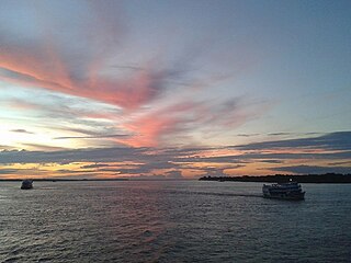
Manaus is the capital and largest city of the Brazilian state of Amazonas. It is the seventh-largest city in Brazil, with an estimated 2020 population of 2,219,580 distributed over a land area of about 11,401 km2 (4,402 sq mi). Located at the east center of the state, the city is the center of the Manaus metropolitan area and the largest metropolitan area in the North Region of Brazil by urban landmass. It is situated near the confluence of the Negro and Solimões rivers. It is the only city in the Amazon Rainforest with a population over 1 million people.

The Paraguayan War, also known as the War of the Triple Alliance, was a South American war that lasted from 1864 to 1870. It was fought between Paraguay and the Triple Alliance of Argentina, the Empire of Brazil, and Uruguay. It was the deadliest and bloodiest inter-state war in Latin American history. Paraguay sustained large casualties, but the approximate numbers are disputed. Paraguay was forced to cede disputed territory to Argentina and Brazil. The war began in late 1864, as a result of a conflict between Paraguay and Brazil caused by the Uruguayan War. Argentina and Uruguay entered the war against Paraguay in 1865, and it then became known as the "War of the Triple Alliance."

The Paraguay River is a major river in south-central South America, running through Brazil, Bolivia, Paraguay and Argentina. It flows about 2,695 kilometres (1,675 mi) from its headwaters in the Brazilian state of Mato Grosso to its confluence with the Paraná River north of Corrientes and Resistencia.

An inland port is a port on an inland waterway, such as a river, lake, or canal, which may or may not be connected to the sea. The term "inland port" is also used to refer to a dry port.
Water resources management is a key element of Brazil's strategy to promote sustainable growth and a more equitable and inclusive society. Brazil's achievements over the past 70 years have been closely linked to the development of hydraulic infrastructure for hydroelectric power generation and just recently to the development of irrigation infrastructure, especially in the Northeast region.
References
- Brazilian Ministry of Transport
- Rand McNally, The New International Atlas, 1993.
| Authority control: National libraries |
|---|