
Tunisia is a country in Northern Africa, bordering the Mediterranean Sea, having a western border with Algeria (965 km) and south-eastern border with Libya (459 km) where the width of land tapers to the south-west into the Sahara. The country has north, east and complex east-to-north coasts including the curved Gulf of Gabès, which forms the western part of Africa's Gulf of Sidra. Most of this greater gulf forms the main coast of Libya including the city of Sirte which shares its root name. The country's geographic coordinates are 34°00′N9°00′E. Tunisia occupies an area of 163,610 square kilometres, of which 8,250 are water. The principal and reliable rivers rise in the north of the country with a few notable exceptions from north-east Algeria and flow through the northern plain where sufficient rainfall supports diverse plant cover and irrigated agriculture.

The Maghreb, also known as Northwest Africa, is the western part of North Africa and the Arab world. The region includes Algeria, Libya, Mauritania, Morocco and Tunisia. The Maghreb also includes the disputed territories of Western Sahara and the Spanish cities Ceuta and Melilla. As of 2018, the region had a population of over 100 million people.

el-Djerid, also al-Jarīd or more precisely the South Western Tunisia Region is a semi-desert natural region comprising three southern Tunisian Governorates, Gafsa, Kebili and Tozeur with adjacent parts of Algeria and Libya.

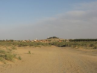
Douz is a town in the Kebili Governorate in the south of Tunisia, known as the "gateway to the Sahara." By road it is located 31 kilometres (19 mi) southwest of Blidet, 125 kilometres (78 mi) southeast of Tozeur, and 475 kilometres (295 mi) south of the Tunisian capital of Tunis.
Djemna, also spelt Jemna, is a small town located in southern Tunisia. The town is part of the Kebili Governorate.

Nefta is a Tunisian municipality and an oasis in Tozeur Governorate north of the Chott el Djerid.
The International Festival of the Sahara is an annual festival held in Douz, Tunisia.
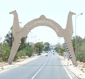
Kebili is a town in the south of Tunisia and one of the main cities in the Nefzaoua region. It is located south of Tunisia. It is the capital of the Kebili Governorate.
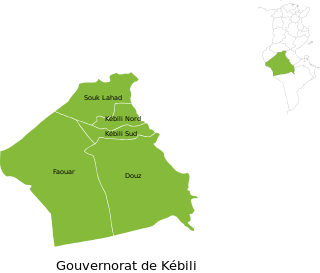
Kebili Governorate is the second largest of the 24 governorates (provinces) of Tunisia. It is situated in south-western Tunisia, bordering Algeria. It covers an area of 22,454 square kilometres (8,670 sq mi) and had a population of 156,961 at the 2014 census. The capital is Kebili.

Chott el Djerid also spelled Sciott Gerid and Shott el Jerid, is a large endorheic salt lake in southern Tunisia. The name can be translated from the Arabic into English as "Lagoon of the Land of Palms".

West Africa Time, or WAT, is a time zone used in west-central Africa. West Africa Time is one hour ahead of Coordinated Universal Time (UTC+01:00), which aligns it with Central European Time (CET) during winter, and Western European Summer Time (WEST) / British Summer Time (BST) during summer.
Jerzyce is a village in the administrative district of Gmina Piotrków Kujawski, within Radziejów County, Kuyavian-Pomeranian Voivodeship, in north-central Poland. It lies approximately 5 kilometres (3 mi) north-west of Piotrków Kujawski, 9 km (6 mi) south-west of Radziejów, and 53 km (33 mi) south of Toruń.
El Golâa is a village in southern Tunisia. It is located southeast of Chott el Djerid a few miles north of Douz in the region of Nefzaoua.

Degache, also spelled Degueche, is a Tunisian town and commune situated in the region of Djerid, and part of Tozeur Governorate. It had a population of 14,332 in 2014, and is the biggest town of a délégation bearing its name.

The Lompoul desert is a small desert located 145 km south of Saint-Louis, Senegal. It is characterized by orange sand dunes forming a landscape that is more akin to those of the Sahara and Mauritania than those of the surrounding area of Senegal, and is a popular tourist attraction of Senegal. The desert is named after the closest settlement, i.e., the village of Lompoul.
Jebil is a national park in Tunisia situated within the Sahara desert. Covering an area of 150,000 hectares, it is the country's second-largest national park, after Senghar-Jebbes National Park. Though large, it is relatively new having been designated a national park in 1994. Until Senghar-Jebbes was declared, it was the only national park within the Sahara desert proper.
Manchevo is a village in Momchilgrad Municipality, Kardzhali Province, southern Bulgaria.
Tinajas is a corregimiento in Dolega District, Chiriquí Province, Panama. It has a land area of 29.4 square kilometres (11.4 sq mi) and had a population of 1,530 as of 2010, giving it a population density of 52 inhabitants per square kilometre (130/sq mi). Its population as of 1990 was 1,084; its population as of 2000 was 1,237.
Ksar Ghilane also known as Henchir Tébournouk is a Tunisian oasis, archaeological site and town of Tataouine Governorate located at 33° 00′ 31″ N, 9° 36′ 59″ E.

