
Agoura Hills is a city in the Santa Monica Mountains region of Los Angeles County, California, United States. Its population was 20,330 at the 2010 census, which decreased to 20,299 in 2020. It is in the eastern Conejo Valley between the Simi Hills and the Santa Monica Mountains. The city is in western Los Angeles County and is bordered to the north by Bell Canyon and Ventura County. It is 35 miles (56 km) northwest of Downtown Los Angeles and less than 10 miles (16 km) west of the Los Angeles city limits at Woodland Hills. Agoura Hills and unincorporated Agoura sit next to Calabasas, Oak Park, and Westlake Village.
The Los Angeles Westside is an urban region in western Los Angeles County, California, United States. It has no official definition, but sources like LA Weekly and the Mapping L.A. survey of the Los Angeles Times place the region on the western side of the Los Angeles Basin south of the Santa Monica Mountains.

The Third Street Promenade is a pedestrian mall esplanade, shopping, dining and entertainment complex in the downtown area of Santa Monica, California which originally opened as the Santa Monica Mall on November 8, 1965. It is considered a premier shopping and dining district on the Westside and draws crowds from all over the Greater Los Angeles area. Due to easy access to Downtown Los Angeles via the Big Blue Bus rapid transit service, E Line's terminus station and the Pacific Coast Highway-Santa Monica Freeway Interstate, the neighborhood's north-south thoroughfares connecting to Muscle Beach, Venice Canal Historic District, Marina del Rey, Ballona Wetlands and Los Angeles International Airport, and its proximity to historic U.S. Route 66, Santa Monica Pier, Palisades Park, Tongva Park, Santa Monica State Beach and the Pacific Ocean coupled with Los Angeles's mild mediterranean climate, it is also a popular tourist destination.
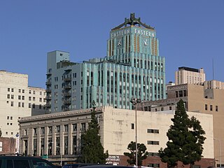
The Historic Core is a district within Downtown Los Angeles that includes the world's largest concentration of movie palaces, former large department stores, and office towers, all built chiefly between 1907 and 1931. Within it lie the Broadway Theater District and the Spring Street historic financial district, and in its west it overlaps with the Jewelry District and in its east with Skid Row.

San Vicente Boulevard is a major northwest-southeast thoroughfare located in the western portion of the metropolitan area of Los Angeles, CA.

Olympic Boulevard is a major arterial road in Los Angeles, California. It stretches from Ocean Avenue on the western end of Santa Monica to East Los Angeles—farther than Wilshire Boulevard and most other streets.

Beverly Boulevard is one of the main east–west thoroughfares in Los Angeles, in the U.S. state of California. It begins off Santa Monica Boulevard in Beverly Hills and ends on the Lucas Avenue overpass near downtown Los Angeles to become 1st Street. A separate Beverly Boulevard begins off 3rd Street and Pomona Boulevard in East Los Angeles, runs through Montebello and Pico Rivera, and becomes Turnbull Canyon Road in Whittier near Rose Hills Memorial Park.

3rd Street in Los Angeles is a major east–west thoroughfare. The west end is in downtown Beverly Hills by Santa Monica Boulevard, and the east is at Alameda Street in downtown Los Angeles, where it shares a one-way couplet with 4th Street. East of Alameda it becomes 4th Street, where it heads to East Los Angeles, where it turns back into 3rd Street upon crossing Indiana Street. 3rd Street eventually becomes Pomona Boulevard in Monterey Park, where it then turns into Potrero Grande Drive and finally turns into Rush Street in Rosemead and ends in El Monte.

Fair Oaks Avenue in Pasadena, California, is a major north–south road connecting the communities of Altadena, Pasadena, and South Pasadena, running 7.9 miles (12.7 km) in length. It starts at its southernmost end in South Pasadena at Huntington Drive. It travels due north to a terminus above Loma Alta Avenue in Altadena and the gates of Angelus County Park. Beyond this, the road becomes a private easement.

Forest Cove is a neighborhood of Agoura Hills, California.
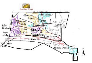
The Historic Quarter is the southeasternmost district of the city of Agoura Hills, south of the Ventura Freeway (101) in western Los Angeles County, California.
Hillrise is an Agoura Hills, California residential neighborhood of modern mid-century detached homes that was first developed in 1968 and into the 1970s. It is located immediately west and south of Downtown, cutting it off from the South End. The neighborhood's character has created a rather bohemian culture, and the area is considered one of the most eclectic neighborhoods in Agoura Hills.

Cahuenga Boulevard is a major boulevard of northern Los Angeles, California, US. The “Cahuenga” name is a Spanish, phonetic derivative with no actual Spanish language meaning that is attributed to the Tongva village of Kawengna, meaning "place of the mountain". It connects Sunset Boulevard in the heart of old Hollywood to the Hollywood Hills and North Hollywood in the San Fernando Valley.

Downtown Pasadena California is the central business district of Pasadena, California. It is centered on Fair Oaks Avenue and Colorado Boulevard and is divided into three distinct neighborhoods: Old Pasadena, the Civic Center, and Monk Hill. Downtown Pasadena is known for its historical buildings that have been preserved throughout the years.

Lamanda Park is a neighborhood in Pasadena, California. It is bordered roughly by Foothill Boulevard to the north, Del Mar Boulevard to the south, the Eaton Wash to the east, and Allen Avenue to the west, with a panhandle extending south along the western bank of the Eaton Wash. Like Annandale, it was originally a small township that was gradually enveloped by Pasadena. It was annexed in 1920. Even today, many commercial enterprises and newspapers still identify the area as a separate community.
The Keck Hospital of USC, formerly USC University Hospital, is a private 401–licensed bed teaching hospital of the University of Southern California (USC). The hospital is part of the USC Keck School of Medicine, it is located on the USC Health Sciences Campus, which is adjacent to the Los Angeles General Medical Center, east of Downtown Los Angeles.
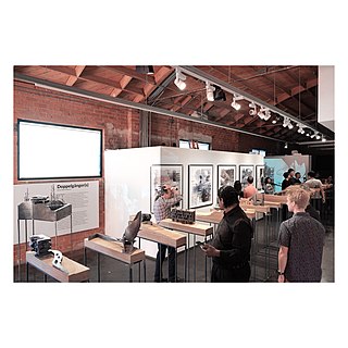
The A+D Museum is a museum of architecture and design located in the Downtown Los Angeles Arts District at 900 E 4th Street. Designer and educator Natasha Sandmeier serves as the museum's executive director and Camille Elston is the managing director.
The Golden Mall was a pedestrianized mall in downtown Burbank, California from 1967 to 1989. It consisted of San Fernando Boulevard from Tujunga Avenue to Magnolia Boulevard, immediately south of the present Burbank Town Center.

South Park is a commercial district in southwestern Downtown Los Angeles, California. It is the location of the Los Angeles Convention Center, the Crypto.com Arena, and the "L.A. Live" entertainment complex.
Timothy Verne Perryman is a missing person. He was last seen March 28, 2004 near his home in Agoura Hills, a Los Angeles, California suburb.