Baton Rouge is the capital city of the U.S. state of Louisiana. Located on the eastern bank of the Mississippi River, it had a population of 227,470 as of 2020; it is the seat of Louisiana's most populous parish (county-equivalent), East Baton Rouge Parish, and the center of Louisiana's second-largest metropolitan area, Greater Baton Rouge.

Interstate 12 (I-12) is an intrastate Interstate Highway located entirely within the US state of Louisiana. It spans a total of 85.59 miles (137.74 km) in an east–west direction from I-10 in Baton Rouge to an interchange with both I-10 and I-59 in Slidell. Along the way, it passes through the city of Hammond, where it intersects I-55 and US Route 51 (US 51). It also serves the cities of Ponchatoula and Denham Springs, as well as the St. Tammany Parish cities of Covington and Mandeville.

Hammond is the largest city in Tangipahoa Parish, Louisiana, United States, located 45 miles (72 km) east of Baton Rouge and 45 miles (72 km) northwest of New Orleans. Its population was 20,019 in the 2010 U.S. census, and 21,359 at the 2020 population estimates program.
U.S. Highway 171 (US 171) is a part of the United States Numbered Highway System and the only route within that system currently located entirely within the state of Louisiana. It spans 177.44 miles (285.56 km) in a north–south direction from the junction of US 90 and Louisiana Highway 14 (LA 14) in Lake Charles to the junction of US 79/US 80 and LA 3094 in Shreveport.

U.S. Route 190 (US 190) is an east–west United States Highway in Louisiana and Texas. Segments of US 190 will be upgraded to Interstate 14 (I-14); the first 24.8-mile (39.9 km) segment was opened on January 26, 2017.

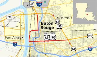
Interstate 110 (I-110) is an auxiliary Interstate Highway in the U.S. state of Louisiana. It runs 9.06 miles (14.58 km) in a north–south direction as a spur of I-10 in the city of Baton Rouge.

The Baton Rouge metropolitan statistical area, as defined by the United States Office of Management and Budget, or simply the Baton Rouge metropolitan area or Greater Baton Rouge, is a sprawling metropolitan statistical area surrounding the city of Baton Rouge. Including the western edge of the Florida Parishes regions, it is known as "Plantation Country", the "Capital Region", and "The 225". At the 2010 U.S. census, the metropolitan area had a population of 802,484, up from 705,973 in 2000. At the 2020 census, its population increased to 870,569, up from 2020 estimates at 858,571.

Interstate 10 (I-10), a major transcontinental Interstate Highway in the Southern United States, runs across the southern part of Louisiana for 274.42 miles (441.64 km) from Texas to Mississippi. It passes through Lake Charles, Lafayette, and Baton Rouge, dips south of Lake Pontchartrain to serve the New Orleans metropolitan area, then crosses Lake Pontchartrain and leaves the state.
Louisiana Highway 10 (LA 10) is a state highway located in southern Louisiana. It runs 255.51 miles (411.20 km) in an east–west direction from U.S. Highway 171 (US 171) south of Leesville to the Mississippi state line east of Bogalusa.

Louisiana Highway 14 (LA 14) is a state highway located in southern Louisiana. It runs 100.10 miles (161.10 km) in an east–west direction from the junction of U.S. Highways 90 and 171 in Lake Charles to LA 182 in New Iberia.
Louisiana Highway 19 (LA 19) is a state highway located in southeastern Louisiana. It runs 33.93 miles (54.61 km) in a north–south direction from U.S. Highway 61 (US 61) in Baton Rouge to the Mississippi state line north of Norwood.
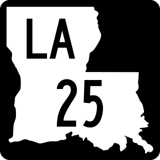
Louisiana Highway 25 (LA 25) is a state highway located in southeastern Louisiana. It runs 38.72 miles (62.31 km) in a north–south direction from U.S. Highway 190 (US 190) in Covington to the Mississippi state line north of Warnerton.

Louisiana Highway 30 (LA 30) is a state highway located in southeastern Louisiana. It runs 28.10 miles (45.22 km) in a northwest to southeast direction from LA 73 in Baton Rouge to the junction of U.S. Highway 61 (US 61) and LA 431 east of Gonzales.

Plan Baton Rouge is a master plan for the redevelopment of the downtown of Baton Rouge, Louisiana. The plan is based on New Urbanist principles.

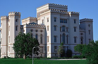
The foundation of Baton Rouge, Louisiana, dates to 1721, at the site of a bâton rouge or "red stick" Muscogee boundary marker. It became the state capital of Louisiana in 1849.

Several special routes of U.S. Route 61 exist in the states of Louisiana, Mississippi, Missouri, and Iowa.

U.S. Highway 65 (US 65) is a part of the United States Numbered Highway System that spans 966 miles (1,555 km) from Clayton, Louisiana to Albert Lea, Minnesota. Within the state of Louisiana, the highway travels 100.77 miles (162.17 km) from the national southern terminus at US 425/LA 15 in Clayton to the Arkansas state line north of Lake Providence.
U.S. Highway 61/190 Business is a business route of both U.S. Route 61 and U.S. Route 190 in Louisiana that serves as a boulevard into downtown Baton Rouge. It spans 10.89 miles (17.53 km) in a southeast to northwest direction and it is signposted as Business 61/190, generally without directional shields. It follows parts of the former alignment of US 61/190 through Baton Rouge, which existed in downtown Baton Rouge from 1935 until 1960.

St. George is the newest incorporated city in Louisiana. It was approved in a ballot initiative on October 12, 2019. Upon incorporation, it became the fifth largest city in Louisiana and the second largest in East Baton Rouge Parish with a population of 86,316. The city originated from a previously unincorporated area of East Baton Rouge Parish located southeast of the City of Baton Rouge.

New Orleans–Baton Rouge passenger rail is a proposed inter-city passenger train service between New Orleans and Baton Rouge along the I-10 corridor in the U.S. state of Louisiana. The route would connect the state's largest city to its second-largest city and state capital with trains as fast as 90 mph (140 km/h).


