
The Downtown Ketchikan Historic District in Ketchikan, Alaska was listed on the National Register of Historic Places in 2017. [1] [2]
The listing was put out for comments in the Federal Register in 2016. [3]
The Downtown Ketchikan Historic District in Ketchikan, Alaska was listed on the National Register of Historic Places in 2017. [1] [2]
The listing was put out for comments in the Federal Register in 2016. [3]

Ketchikan Gateway Borough is a borough located in the U.S. state of Alaska. As of the 2010 census, the population was 13,477. The borough seat is Ketchikan. the borough is the second most populous borough in Southeast Alaska, behind Juneau Borough.

Ketchikan is a city in and the borough seat of the Ketchikan Gateway Borough of Alaska. It is the state's southeasternmost major settlement. Downtown Ketchikan is a National Historic District. With a population at the 2010 census of 8,050, it is the fifth-most populous city in the state, and tenth-most populous community when census-designated places are included. The surrounding borough, encompassing suburbs both north and south of the city along the Tongass Highway, plus small rural settlements accessible mostly by water, registered a population of 13,477 in that same census. Estimates put the 2017 population at 13,754 people. Incorporated on August 25, 1900, Ketchikan is the earliest extant incorporated city in Alaska, because consolidation or unification elsewhere in Alaska resulted in dissolution of those communities' city governments. Ketchikan is located on Revillagigedo Island, so named in 1793 by Captain George Vancouver.

Saxman is a city on Revillagigedo Island in Ketchikan Gateway Borough in southeastern Alaska, United States. At the 2010 census the population was 411, down from 431 in 2000. The city of Ketchikan lies just to its northwest.
Revillagigedo Island is an island in the Alexander Archipelago in Ketchikan Gateway Borough of the southeastern region of the U.S. state of Alaska. Running about 89 km (50 mi) north-south and 48 km (35 mi) east-west, it is 2,754.835 km² (1,063.65 mi²) in area, making it the 12th largest island in the United States and the 167th largest island in the world. Its center is located near 55°38′03″N131°17′51″W.

Annette Island or Taak'w Aan (Tlingit) is an island in the Gravina Islands of the Alexander Archipelago of the Pacific Ocean on the southeastern coast of the U.S. state of Alaska. It is at 55°08′06″N131°27′21″W. It is about 18 km (11 mi) long and about 18 km (11 mi) wide. The land area is 332.573 km2 (128.407 sq mi). Annette Island is located west across the Revillagigedo Channel from the Alaska mainland and south of Revillagigedo Island. The Island was named in 1879 by William Healey Dall, an American naturalist and explorer in Alaska, in honor of his wife Annette Whitney Dall.

Gravina Island is an island in the Gravina Islands of the Alexander Archipelago in southeastern Alaska. It is 21 miles (34 km) long and about 9.5 miles (15.3 km) wide, with a land area of 94.81 square miles (245.6 km2). The island had a population of 50 people at the 2000 census.
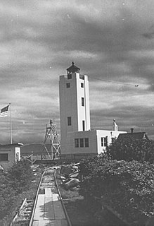
The Mary Island Light Station is a lighthouse located on the northeastern part of Mary Island in southeastern Alaska, United States.

KRBD is a non-commercial radio station in Ketchikan, Alaska, broadcasting on 105.3 FM. The station airs public radio programming from the National Public Radio network, the BBC World Service, and is a member of CoastAlaska. KRBD also airs some locally originated programming.
KGTW is a commercial country music radio station in Ketchikan, Alaska, broadcasting on 106.7 FM.

This is a list of the National Register of Historic Places listings in Ketchikan Gateway Borough, Alaska.
Cape Pole is a former census-designated place (CDP) and populated place on the eastern shore of Fishermans Harbor, on the southwest coast of Kosciusko Island in Prince of Wales-Hyder Census Area, Alaska. It was a thriving logging camp from 1954 until it was shut down by a federal court ruling in 1978. A post office was established in 1949 and discontinued in 1953. As of 2019, some buildings still remain at the townsite, but has not reported a separate population since 1980.

Loring was established in 1885 with the first post office in the District of Alaska and is a census-designated place (CDP) in Ketchikan Gateway Borough in the U.S. state of Alaska. The population was 4 at the 2010 census, although the number increases in summer months.

Tongass Narrows is a Y-shaped channel, part of Southeast Alaska's Inside Passage. The waterway forms part of the Alaska Marine Highway and as such, is used by charter, commercial fishing, and recreational vessels, as well as commercial freight barges and tanks, kayaks and passenger ferries.

Pennock Island is located in the U.S. state of Alaska near the city of Ketchikan. The island is situated within the Ketchikan Gateway Borough and is part of the Alexander Archipelago. Most of the island is public land managed by the Tongass National Forest.

Ketchikan Creek is a waterway on Revillagigedo Island in the U.S. state of Alaska. It heads in a lake and travels 6 miles (9.7 km) to Tongass Narrows. The historic Creek Street in Ketchikan runs along the creek banks as a piling-perched boardwalk.
The Clover Pass School is a historic school building in Ketchikan Gateway Borough, Alaska. It is located 16 miles (26 km) north of the city of Ketchikan, at the junction of Potter and Knudson Cove Roads. The small one-room wood-frame structure was built in 1947, and was used as a school until 1961. It thereafter was used as a local community center and is now owned by Historic Ketchikan.

The Stedman–Thomas Historic District encompasses what was historically the southern portion of Ketchikan, Alaska. It extends along Stedman and Thomas Streets, from Ketchikan Creek in the north to East Street in the south, and includes a few properties on adjacent spur side streets. In the early days of the city, the area was a seasonal Native fishing camp just south of the creek, but the Alaskan gold rushes around the turn of the 20th century brought an influx of settlers to the area.

Creek Street is a historic area of Ketchikan, Alaska. The street is actually a boardwalk mounted in stilts on a high slope on the east side of Ketchikan Creek, east of the city's downtown. Creek Street was listed on the National Register of Historic Places in 2014.
Coast Guard Base Ketchikan is a major shore installation of the United States Coast Guard located in Ketchikan, Alaska. The base is a homeport for two Sentinel-class cutters and a buoy tender, and is the only Coast Guard dry dock in the state. Located one mile south of the city's downtown area along the southwestern shore of Revillagigedo Island, the base was originally established in 1920 to support the United States Lighthouse Service and became part of the Coast Guard in 1940. In addition to the homeported cutters, Base Ketchikan's maintenance facilities support forward-deployed cutters throughout Southeast Alaska, in Petersburg, Juneau and Sitka.
Clover Pass is an unincorporated community in Ketchikan Gateway Borough, Alaska. Workers organized and built the Clover Pass School in 1947 and it was used as a community center in the 1960s. Wards Cove was a shipwreck in the area after an engine fire sank it in 1929. The area, on Clover Passage, includes a marina and is popular for sportfishing as well as kayaking and sailing. It is home to Clover Pass Resort including campsites.
Coordinates: 55°20′18″N131°38′04″W / 55.3383°N 131.6345°W
| This article about a location in the Ketchikan Gateway Borough, Alaska is a stub. You can help Wikipedia by expanding it. |