
Downtown Whitehorse is a neighbourhood in Whitehorse, Yukon, Canada. The downtown area serves as Whitehorse's city centre and central business district.
Downtown Whitehorse is a neighbourhood in Whitehorse, Yukon, Canada. The downtown area serves as Whitehorse's city centre and central business district.
Downtown Whitehorse originally encompassed the entirety of Whitehorse prior to the Second World War. After the war, the periphery was developed, with residents beginning to move into the Riverdale subdivision on the east bank of the river, and to suburbs outside the city limits such as Porter Creek, then to the Takhini and Hillcrest subdivisions after the military withdrew from the city in 1968. In 1971, the city limits were extended beyond downtown, officially establishing a larger city with the original area now merely the downtown area of a much larger municipal area. [1]

Downtown Whitehorse is the commercial centre of the city. The Yukon Legislative Building is located in this area and was built in 1976. [2] It is generally considered to extend from the narrows between the clay cliffs and the Yukon River just south of Taylor Street, north to the east–west leg of the Second Avenue extension, and from the Yukon River to the base of the clay cliffs. Business activities are mainly confined to 1st, 2nd, 3rd and 4th avenues, as well as adjacent sections of the cross streets, and mainly north of Hanson Street (third street south of Main). The remainder of the downtown is primarily residential.
Parks Canada maintains the S.S. Klondike national historic site in the southeast corner of downtown next to Second Avenue and the river; just to its north is Rotary Peace Park; together, these properties historically were squatter areas cleared in the late 1960s, known as Whiskey Flats South.
North of this along the river were the waterfront properties most of which were concerns of the White Pass and Yukon Route railway until 1986, when railway interest in retaining these properties waned; most of it is now owned by the city and the territorial government which are focusing on making the area a public area with some businesses and trails; it also has the "waterfront trolley" operating through the area. Beyond the present extent of Front Street (1st Avenue), there was a second squatter area known as Whiskey Flats North extending to the approximate location of the Wal-Mart store built in 2000; part of this was also where riverboats were moored in the winter, and where two riverboats were lost to fire in 1974.

As well as the numbered avenues 2nd, 3rd, 4th, 5th, 6th, 7th and 8th and the parallel Front Street (officially known for many years as 1st Avenue), the named streets delineate addresses along the avenues.

Whitehorse is the capital of the Yukon, and the largest city in Northern Canada. It was incorporated in 1950 and is located at kilometre 1426 on the Alaska Highway in southern Yukon. Whitehorse's downtown and Riverdale areas occupy both shores of the Yukon River, which rises in British Columbia and meets the Bering Sea in Alaska. The city was named after the White Horse Rapids for their resemblance to the mane of a white horse, near Miles Canyon, before the river was dammed.

Yukon is the smallest and westernmost of Canada's three territories. It is the most densely populated territory in Canada, with an estimated population of 46,704 as of 2024, though it has a smaller population than all provinces. Whitehorse, the territorial capital, is the largest settlement in any of the three territories.

Dawson City, officially the City of Dawson, is a city in the Canadian territory of Yukon. It is inseparably linked to the Klondike Gold Rush (1896–1899). Its population was 1,577 as of the 2021 census, making it the second-largest city in Yukon.

Downtown Pittsburgh, colloquially referred to as the Golden Triangle, and officially the Central Business District, is the urban downtown center of Pittsburgh, Pennsylvania, United States. It is located at the confluence of the Allegheny River and the Monongahela River whose joining forms the Ohio River. The triangle is bounded by the two rivers.

Downtown Louisville is the largest central business district in the Commonwealth of Kentucky and the urban hub of the Louisville, Kentucky Metropolitan Area. Its boundaries are the Ohio River to the north, Hancock Street to the east, York and Jacob Streets to the south, and 9th Street to the west. As of 2015, the population of downtown Louisville was 4,700, although this does not include directly surrounding areas such as Old Louisville, Butchertown, NuLu, and Phoenix Hill.

Downtown Portland is the central business district of Portland, Oregon, United States. It is on the west bank of the Willamette River in the northeastern corner of the southwest section of the city and where most of the city's high-rise buildings are found.

Harbor Drive is a short roadway in Portland, Oregon, spanning a total length of 0.7 miles (1.1 km), which primarily functions as a ramp to and from Interstate 5. It was once much longer, running along the western edge of the Willamette River in the downtown area. Originally constructed from 1942–43, the vast majority of the road was replaced with Tom McCall Waterfront Park in the 1970s. Signed as U.S. Route 99W, it had been the major route through the city and its removal is often cited as the first instance of freeway removal in the U.S. and as a milestone in urban planning; the original road is remembered as the first limited-access highway built in the city.
Marsh Lake is an unincorporated community on the Alaska Highway on the shores of Marsh Lake southeast of Whitehorse in Canada's Yukon. The area was organized in 2001, as a local area council to help the residents with some form of municipal government.
Canyon City is a Klondike Gold Rush ghost town and a Yukon Government Heritage Site. It is located about 7 km from downtown Whitehorse, Yukon, at the upstream end of Miles Canyon on the Yukon River. Summer tours are encouraged.

Neighborhoods in Spokane, Washington are officially grouped by the Spokane City Council into three main city council districts: 1, 2, and 3. Each city council district contains multiple, official neighborhoods that are recognized with a neighborhood council. Informally, neighborhoods are colloquially grouped by local geographical, geological, cultural, or historical features The list of neighborhoods below is organized based on the official designations by the City of Spokane. Unofficial neighborhoods and districts are listed within the official neighborhood in which they are located.

Whitehorse West is an electoral district which returns a member to the Legislative Assembly of the Yukon Territory in Canada.
Columbus, the state capital and Ohio's largest city, has numerous neighborhoods within its city limits. Neighborhood names and boundaries are not officially defined. They may vary or change from time to time due to demographic and economic variables.

CFWH-FM is a Canadian radio station broadcasting at 94.5 MHz FM in Whitehorse, Yukon. The station broadcasts the programming of the CBC Radio One network known as CBC North. Until its closure in 2012, CFWH's sister television station was CFWH-TV.
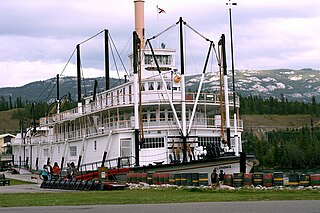
SS Klondike is the name of two sternwheelers, the second now a National Historic Site located in Whitehorse, Yukon. They ran freight between Whitehorse and Dawson City, along the Yukon River, the first from 1929 to 1936 and the second, an almost exact replica of the first, from 1937 to 1950.
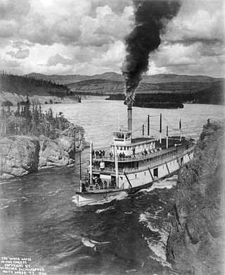
Steamboats on the Yukon River played a role in the development of Alaska and Yukon. Access to the interior of Alaska and Yukon was hindered by large mountains and distance, but the wide Yukon River provided a feasible route. The first steamers on the lower Yukon River were work boats for the Collins Overland Telegraph in 1866 or 1867, with a small steamer called Wilder. The mouth of the Yukon River is far to the west at St. Michael and a journey from Seattle or San Francisco covered some 4,000 miles (6,400 km).

The Whitehorse Waterfront Trolley is a heritage streetcar service in Whitehorse, Yukon, Canada.

The MacBride Copperbelt Mining Museum formally the Copperbelt Railway & Mining Museum (CR&MM) is run by the Miles Canyon Historic Railway Society (MCHRS), which consists of a board of six members. The objectives of the society are to: a) To preserve, promote and to protect the railway heritage of the Yukon; b) To develop and operate the Waterfront Trolley; c) To develop and operate the Copperbelt Railway & Mining Museum; and d) To promote and enhance tourism development in the city of Whitehorse and the Yukon.

The SS Keno is a preserved historic sternwheel paddle steamer, a National Historic Site of Canada, and a unit of the Canadian national park system. The SS Keno is berthed in a dry dock on the waterfront of the Yukon River in Dawson City, Yukon, Canada.