
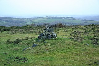
Childe's Tomb is a granite cross on Dartmoor, Devon, England. Although not in its original form, it is more elaborate than most of the crosses on Dartmoor, being raised upon a constructed base, and it is known that a kistvaen is underneath.

Dartmoor is an upland area in southern Devon, England. The moorland and surrounding land has been protected by National Park status since 1951. Dartmoor National Park covers 954 km2 (368 sq mi).

The River Dart is a river in Devon, England, that rises high on Dartmoor and flows for 75 kilometres (47 mi) to the sea at Dartmouth.

Buckfastleigh is a market town and civil parish in Devon, England situated beside the Devon Expressway (A38) at the edge of the Dartmoor National Park. It is part of Teignbridge and, for ecclesiastical purposes, lies within the Totnes Deanery. It is 18 miles east-northeast of Plymouth, 20 miles southwest of Exeter and has a population of 3,661. It is a centre of tourism and is home to Buckfast Abbey, the South Devon Railway, the Buckfastleigh Butterfly Farm and Otter Sanctuary, the Tomb of Squire Richard Cabell and The Valiant Soldier.

Moretonhampstead is a market town, parish and ancient manor in Devon, situated on the north-eastern edge of Dartmoor, within the Dartmoor National Park. The parish now includes the hamlet of Doccombe, and it is surrounded clockwise from the north by the parishes of Drewsteignton, Dunsford, Bridford, Bovey Tracey, Lustleigh, North Bovey and Chagford.

The River Teign is a river in the county of Devon, England. It is 31 mi (50 km) long and rises on Dartmoor, becomes an estuary just below Newton Abbot and reaches the English Channel at Teignmouth.

High Willhays, or according to some authorities High Willes, is the highest point on Dartmoor, Devon, at 621 metres above sea level, and the highest point in Southern England.

The Great Thunderstorm of Widecombe-in-the-Moor in Dartmoor, Kingdom of England, took place on Sunday, 21 October 1638, when the church of St Pancras was apparently struck by ball lightning during a severe thunderstorm. An afternoon service was taking place at the time, and the building was packed with approximately 300 worshippers. Four of them were killed, around 60 injured, and the building severely damaged.
Holne is a village and civil parish on the southeastern slopes of Dartmoor in Devon, England. A community has existed here since at least the 11th century, and today a population of around 250 people is served by a church and a public house, the Church House Inn.

The Dartmoor line is a 15+1⁄2-mile (24.9 km) railway line in Devon, England. From Crediton, the line runs alongside the Tarka Line to the site of the former Coleford Junction where it diverges west to Okehampton. Previously a heritage line, it is owned by Network Rail.

The Two Moors Way is a long-distance trail mostly in Devon, UK, first established in 1976. It links Dartmoor and Exmoor and has been extended to become a Devon Coast-to-Coast trail.
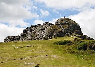
Haytor, also known as Haytor Rocks, Hay Tor, or occasionally Hey Tor, is a granite tor on the eastern edge of Dartmoor in the English county of Devon.

The Haytor Granite Tramway was a tramway built to convey granite from Haytor Down, Dartmoor, Devon to the Stover Canal. It was very unusual in that the track was formed of granite sections, shaped to guide the wheels of horse-drawn wagons.
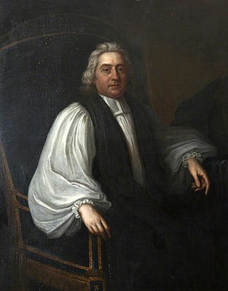
Ofspring Blackall, Bishop of Exeter and religious controversialist, was born in London.

The Dartmoor crosses are a series of stone crosses found in Dartmoor National Park in the centre of Devon, England. Many of them are old navigational aids, needed because of the remoteness of the moorland and its typically bad weather. Some mark medieval routes between abbeys. Other crosses were erected as memorials, for prayer, as town or market crosses, in churchyards, and as boundary markers. The crosses were erected over a long period of time, some as recently as 100 years ago, the earliest probably almost 1,000 years ago.
The Plymouth and Dartmoor Railway (P&DR) was a 4 ft 6 in gauge railway built to improve the economy of moorland areas around Princetown in Devon, England. Independent carriers operated horse-drawn wagons and paid the company a toll. It opened in 1823, and a number of short branches were built in the next few years.

Spitchwick is an historic estate situated within the parish of Widecombe-in-the-Moor, Devon. The present 19th century mansion house known as Spitchwick Manor is situated four miles north-west of Ashburton, the gardens of which are open to the paying public.
Sandridge is an historic estate in the parish of Stoke Gabriel in Devon, situated on high ground at the head of the River Dart estuary. The estate was originally encompassed on three sides by the river, which meanders along its border, leaving it on the east side. The present grade II* listed Italianate style Regency mansion house known as Sandridge House was built in 1805 by Lady Ashburton, to the design of John Nash.
Aish Tor is a small tor above the northern side of the Dart Gorge in Dartmoor, Devon, England, that is accessed by Dr. Blackall's Drive from Newbridge Hill. It stands at 283 metres (928 ft) above sea level and is topped by a small cairn. The actual 'tor' is small and flat and generally hard to pin-point. Nearby tors include:
Dr Thomas Blackall M.A., M.D., FRCP was an English physician, son of another renowned physician John Blackall. Born in Devon, he attended Cambridge, before working as a physician in London, and then returning to Devon on the death of his father, where he used his inheritance to purchase the large Spitchwick estate.
