Drake House (Newfoundland)

Last updated
Drake House ArnoldsCoveNL DrakeHouse.JPG
Drake House

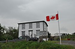
The Drake House is a two-story house with a low-pitched gable roof. It is located at 319 Main Road, Arnold's Cove, Newfoundland and Labrador, Canada.

Contents

History of the property

Drake House was constructed in the 1890s in the community of Haystack, Placentia Bay. It was constructed by George Drake and his brother John. Frank Drake, George's son, inherited the property and lived in the building all his life. When Haystack was resettled Frank Drake refused to move, and remained in the house at Haystack for an additional 12 years. In 1969 the house was floated by barge from Haystack to its present site in Arnold's Cove. Frank Drake died in 2002, and was buried at Haystack. [1]

The oldest house standing in Arnold's Cove, the property has since been acquired by the Town of Arnold's Cove and has been restored. It now serves as a historical interpretation centre and community museum, and has housed demonstrations of traditional crafts such as knitting and quilting. [2] The building was officially opened July 7, 2005. [3]

Construction type

Drake House under restoration circa 2004 Drake House under restoration circa 2004 CCBY Heritage NL.jpg
Drake House under restoration circa 2004


The house itself is of wood construction with a tar paper roof, and follows a standard Georgian central hall plan. On the exterior, the building features decorative woodwork on the corner boards and above the windows and central doorway on the main facade. Historical photographs indicate that the central doorway, with its original etched glass door intact, never had a bridge or stairway leading to it. The door then was probably never used as an entranceway, neither before nor after its relocation from Haystack. In 2016, it was noted:

There has been little change made to the interior of the building, and the upstairs portion of the house in particular is well preserved. The interior features a fine central staircase, unpainted wood trim, and largely unpainted tongue and groove ceilings with wood medallions. Several original pieces of furniture, a trunk of papers belonging to Frank Drake, old patent medicine bottles, a bed with its original straw mattress, and many other artifacts dating to the resettlement period remain in the building. [4]

Heritage designation and museum

The Drake House was designated a Registered Heritage Structure on March 27, 2003 by the Heritage Foundation of Newfoundland and Labrador. The property was designated as a representative example of those buildings that were floated out across Placentia Bay during the resettlement period. The structure is symbolic of that episode of Newfoundland's history, and is commemorative of that time. The building is listed on the Canadian Register of Historic Places. [5] It was restored circa 2004 and opened as a community museum.

Plaque commemorating the Drake House as a Registered Heritage Structure Drake House Arnold's Cove plaque.jpg
Plaque commemorating the Drake House as a Registered Heritage Structure

In 2018, the heritage committee a series of quilting events, [6] which culminated in the participants crafting a crazy quilt to adorn Frank Drake's bed. [7] The museum has also been involved in traditional boat building events, [8] and commemorating the resettlement era through a mobile app. [9]

See also

Related Research Articles

Division No. 1, Subdivision A is an unorganized subdivision on the Avalon Peninsula in Newfoundland and Labrador, Canada. It is in Division No. 1, and lies between Trinity Bay and Placentia Bay.

<span class="mw-page-title-main">Arnold's Cove</span> Town in Newfoundland and Labrador, Canada

Arnold's Cove is a town on Newfoundland's Avalon Peninsula in the province of Newfoundland and Labrador, Canada. It is in Division 1 on Placentia Bay.

<span class="mw-page-title-main">Division No. 1, Newfoundland and Labrador</span> Census division in Newfoundland and Labrador, Canada

Division 1, Newfoundland and Labrador is a census division covering the entire Avalon Peninsula including the Isthmus of Avalon of the Canadian province of Newfoundland and Labrador. Like all census divisions in Newfoundland and Labrador, but unlike the census divisions of some other provinces, the division exists only as a statistical division for census data, and is not a political entity.

<span class="mw-page-title-main">Bellevue (electoral district)</span> Provincial electoral district in Newfoundland and Labrador, Canada

Bellevue is a former provincial electoral district for the House of Assembly of Newfoundland and Labrador, Canada. As of 2003 it had 7310 eligible voters. The district was abolished in 2015 and replaced by Placentia West-Bellevue.

<span class="mw-page-title-main">Placentia-St. Mary's</span> Provincial electoral district in Newfoundland and Labrador, Canada

Placentia—St. Mary's is a provincial electoral district for the House of Assembly of Newfoundland and Labrador, Canada. As of 2011, there were 7,361 eligible voters living within the district.

<span class="mw-page-title-main">Ferryland (electoral district)</span> Provincial electoral district in Newfoundland and Labrador, Canada

Ferryland is a provincial electoral district for the House of Assembly of Newfoundland and Labrador, Canada. As of 2011, there are 8,571 eligible voters living within the district.

<span class="mw-page-title-main">Glovers Harbour, Newfoundland and Labrador</span> Local service district / designated place in Newfoundland and Labrador, Canada

Glovers Harbour, formerly known as Thimble Tickle(s), is an unincorporated community and harbour in the Canadian province of Newfoundland and Labrador. It is located in Notre Dame Bay on the northern coast of the island of Newfoundland. As a local service district, it is led by an elected committee that is responsible for the delivery of certain essential services. It is delineated as a designated place for statistical purposes.

The House of Assembly Channel is a cable television channel broadcast throughout much of Newfoundland and Labrador, exclusively on cable. The channel first signed on the air on November 17, 2001.

Bay de Verde is an incorporated town in Conception Bay on the northern tip of the Bay de Verde Peninsula of Newfoundland and Labrador, Canada. The first recorded inhabitants at Bay de Verde arrived in 1662. Bay de Verde became an incorporated town in 1950.

Articles related to the Canadian province of Newfoundland and Labrador include:

New-Wes-Valley is a municipality in Newfoundland and Labrador, Canada.

Oderin Island is an island in the province of Newfoundland and Labrador in western Placentia Bay, located about 30 km northeast of Marystown. Oderin was originally settled by the French who considered it an important fishing post and had fortified it against the English. The name was originally Audierne, named after a town in France. In 1712, the French authorities in Placentia ordered all the buildings and fishing premises to be burned or destroyed, in part to deny to English the use of the site but also as retribution against the local French merchant Lafosse who had deserted to and collaborated with the English. This did not happen, however, as English Captain Tavener's second report indicates that Lafosse's abandoned wife was still present in May 1718 and running a prosperous operation.

<span class="mw-page-title-main">Hampden, Newfoundland and Labrador</span> Town in Newfoundland and Labrador, Canada

Hampden is a town in the Canadian province of Newfoundland and Labrador. The town has a population of 429. Two islands can be seen from the shore of Hampden, Granby Island and Millers Island. The latter is much closer to the town and is the host of a tuberculosis grave-site.

<span class="mw-page-title-main">Humber Arm South</span> Town in Newfoundland and Labrador, Canada

Humber Arm South is a town in the Canadian province of Newfoundland and Labrador. The town had a population of 1,537 in the Canada 2021 Census. The Town's Post Office is located in the section of the town referred to as Benoit's Cove. Humber Arm South is located in the Bay of Islands, and is in the Humber-Bay of Islands electoral district.

O'Donnells is a local service district and designated place in the Canadian province of Newfoundland and Labrador. It is southeast of Placentia. The first postmistress was Mrs. Theresa M. Hanlon on July 16, 1951. By 1956 there was a population of 244.

Haystack was a former fishing settlement located on the northern portion of Long Island, Placentia Bay of the island of Newfoundland in the province of Newfoundland and Labrador, Canada. People from the community freely chose to move to other places in the province during the resettlement program of the 1950s and 60s. Unlike most communities, residents were not paid to leave the community.

<span class="mw-page-title-main">Fort Saint Louis (Newfoundland)</span>

Fort Saint Louis was a French fort built in the 17th century on the island of Newfoundland at the time of the New France.

Division No. 1, Subdivision C is an unorganized subdivision on the Avalon Peninsula in Newfoundland and Labrador, Canada. It is in Division 1 and contains the unincorporated communities of Cape St. Mary's, Cuslett, Gooseberry Cove, Great Barasway, Lears Cove, Patrick's Cove-Angels Cove, Ship Cove and Stoney House.

<span class="mw-page-title-main">Division No. 1, Subdivision G, Newfoundland and Labrador</span> Unorganized territory in Newfoundland and Labrador, Canada

Division No. 1, Subdivision G is an unorganized subdivision on the Avalon Peninsula in Newfoundland and Labrador, Canada. It is in Division 1 and contains the unincorporated communities of Baccalieu Island, Besom Cove, Bradley's Cove, Burnt Point, Caplin Cove, Daniel's Cove, Grates Cove, Gull Island, Job's Cove, Kingston, Long Beach, Lower Island Cove, Low Point, Northern Bay, Ochre Pit Cove, Red Head Cove, Riverhead, Smooth Cove and Western Bay.

Long Island is a long narrow island located in the inner portion of Placentia Bay. The longest axis of the island lies in a north-south direction. It is approximately 24 kilometres long and just over 3 kilometres at its widest point. Long Island along with Merasheen Island and Red Island make up the majority of the islands in Placentia Bay. Long Island is located approximately 22 kilometres northwest of Argentia. It is separated from Merasheen Island to the west by a 24 kilometre long channel that narrows to within 2.12 kilometres. Red Island is approximately 10 kilometres to the southwest of Long Island.

References

  1. "Frank Drake".
  2. "Arnold's Cove celebrates Heritage Week". The Telegram. Jul 21, 2017. Retrieved 12 June 2020.
  3. "The Drake House" (PDF). Haystack Reunion Newsletter. 11: 2. June 2005. Retrieved 12 June 2020.
  4. "Drake House (Arnold's Cove)". Heritage Newfoundland and Labrador. Memorial University. Retrieved 12 June 2020.
  5. HistoricPlaces.ca - HistoricPlaces.ca
  6. "Some good day on quilts in Arnold's Cove". The Packet. 19 July 2018. p. A11.
  7. Squibb, Mark (27 September 2018). "Arnold's Cove community group finishes Frank's Quilt to be displayed at the Drake House". The Packet. p. A8.
  8. Squibb, Mark (19 July 2018). "Preparing to launch". The Packet. p. A1.
  9. "New app sharing stories of Placentia Bay resettlement". The Packet. Vol. 49, no. 6. 2 March 2017. p. A2.

Coordinates: 47°45′37″N53°59′08″W / 47.76017°N 53.98569°W / 47.76017; -53.98569