After the Reformation, the king confiscated Essenbæk Abbey and its estate in 1540,[7] and when Drastrup was acquired on August 22, 1661, from the king by Hans Friis, there were six farms in the village.[8] Its location on moraine hills shows that agriculture was prioritized there, but cattle were probably kept on the meadows below the village.[2]
On March 18, 1695, Hans Friis gave[9] Essenbæk Home Farm (Essenbæk Ladegård), including adjoining estates, to his nephew Christian Friis,[10] who on February 15, 1726, incorporated them into the entailed estate of Tustrup.[11] On October 30, 1782, the king gave permission for the sale of the estate, and Essenbæk Home Farm was sold at auction at Tustrup on December 18, 1783, to Christian Kallager; the deed was signed on June 11, 1785.[12]
However, as early as June 10,[13] 1787, he sold it to Peter Severin Fønss and Johan Frederik Carøe.[14] In that year there were in Drastrup six farms, a smallholding and two houses,[15] in which resided 87 people.[16] Before the end of the following year the village was sold to the tenant farmers there,[17] who subdivided it among themselves.[18]
Drastrup School in ca. 1880.
A newly built school was opened in Drastrup March 1, 1859,[20] and Drastrup Co-operative Society (Drastrup Brugsforening) was established in 1900.[21]
In the village the Virring-Essenbæk Municipality and the Årslev-Hørning Municipality opened September 1, 1959, the Sønderhald hundred Central School (Sønderhald herreds Forbundsskole),[22] also called the Sønderhald School (Sønderhaldskolen),[23] and February 1, 1960, the previous school there was closed as such.[22] Drastrup Co-operative Society was abolished in 1965,[24] but in 1968 a sports ground and a clubhouse were constructed at the Sønderhald School.[23]
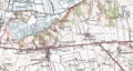
From February 28, 1973,[25] the Sønderhald Municipality decided to expand the residential area of Assentoft East (Assentoft Øst) with inter alia parts of Drastrup, including the Sønderhald School,[25] so that the village is becoming surrounded by Assentoft.[26] However, the village environment, with several farm structures, is relatively well-preserved.
Assentofts surrounding of Drastrup
Map from 1976
Map from 2001
Map from 2016
Geography
The landscape in and around Drastrup is relatively flat, with few hills.[27]
↑Mariager, Rasmus (1937).ESSENBÆK SOGNS HISTORIE: SAMLET OG UDGIVET AF R. Mariager. Odder, Denmark; Duplikeringsbureauet, p. 7
↑Mariager, Rasmus (1937). ESSENBÆK SOGNS HISTORIE: SAMLET OG UDGIVET AF R. Mariager. Odder, Denmark; Duplikeringsbureauet, p. 11
↑West, F. J. (1908). Kronens Skøder: paa afhændet og erhvervet Jordegods i Danmark, fra Reformationen til Nutiden. Andet Bind. 1648-1688. Copenhagen, Denmark; Rigsarkivet, p. 101
↑Hansen, Karl (1832). Danske Ridderborge, beskrevne tildeels efter utrykte Kilder. Copenhagen, Denmark; Hofboghandler Beekens Forlag, p. 102
↑Nielsen, Niels; Skautrup, Peter; Mathiassen, Therkel (1963). J. P. TRAP: DANMARK. FEMTE UDGAVE. REDIGERET AF NIELS NIELSEN • PETER SKAUTRUP • THERKEL MATHIASSEN. RANDERS AMT. BIND VII, 2. Copenhagen, Denmark: G. E. C. Gads Forlag, p. 862
↑Hansen, Karl (1832). Danske Ridderborge, beskrevne tildeels efter utrykte Kilder. Copenhagen, Denmark; Hofboghandler Beekens Forlag, p. 142
↑Hansen, Karl (1832). Danske Ridderborge, beskrevne tildeels efter utrykte Kilder. Copenhagen, Denmark; Hofboghandler Beekens Forlag, p. 143
↑Hansen, Karl (1832). Danske Ridderborge, beskrevne tildeels efter utrykte Kilder. Copenhagen, Denmark; Hofboghandler Beekens Forlag, p. 145
↑Nielsen, Niels; Skautrup, Peter; Mathiassen, Therkel (1963). J. P. TRAP: DANMARK. FEMTE UDGAVE. REDIGERET AF NIELS NIELSEN • PETER SKAUTRUP • THERKEL MATHIASSEN. RANDERS AMT. BIND VII, 2. Copenhagen, Denmark: G. E. C. Gads Forlag, p. 848
↑Mehlsen, Ejnar (1919).Essenbæk KlosterinAarbog udgivet af Randers Amts Historiske Samfund. Årgang 13. 52-60. Randers, Denmark: Randers Amts Historiske Samfund, p. 60
↑Mariager, Rasmus (1937).ESSENBÆK SOGNS HISTORIE: SAMLET OG UDGIVET AF R. Mariager. Odder, Denmark; Duplikeringsbureauet, p. 18
↑Nielsen, Niels; Skautrup, Peter; Mathiassen, Therkel (1963).J. P. TRAP: DANMARK. FEMTE UDGAVE.REDIGERET AF NIELS NIELSEN • PETER SKAUTRUP • THERKEL MATHIASSEN. RANDERS AMT. BIND VII, 2. Copenhagen, Denmark: G. E. C. Gads Forlag, p. 847
↑Mariager, Rasmus (1937).ESSENBÆK SOGNS HISTORIE: SAMLET OG UDGIVET AF R. Mariager. Odder, Denmark; Duplikeringsbureauet, p. 91
↑Sørensen, Steffen (1999). Drastrup skole 1854-1960 in Årsskrift 1999. Auning, Denmark: Lokalhistorisk forening for Sønderhald Kommune og Sønderhalds Egnsarkiv, p. 10
↑Sørensen, Steffen (1999). Drastrup skole 1854-1960 in Årsskrift 1999. Auning, Denmark: Lokalhistorisk forening for Sønderhald Kommune og Sønderhalds Egnsarkiv, p. 9
↑Mariager, Rasmus (1937). ESSENBÆK SOGNS HISTORIE: SAMLET OG UDGIVET AF R. Mariager. Odder, Denmark; Duplikeringsbureauet, pp. 105-106
12Sørensen, Steffen (1999). Drastrup skole 1854-1960 in Årsskrift 1999. Auning, Denmark: Lokalhistorisk forening for Sønderhald Kommune og Sønderhalds Egnsarkiv, p. 12
12Idræts- og Kulturcenter Assentoft hallerne (2000). Assentoft hallerne 25 år 1975-2000. Auning, Denmark; Djurs Gruppen, p. 3
This page is based on this Wikipedia article Text is available under the CC BY-SA 4.0 license; additional terms may apply. Images, videos and audio are available under their respective licenses.