The forest lies south of the A12 and the railway Utrecht-Arnhem and runs to the built-up area of Driebergen-Rijsenburg at Willem van Abcoudelaan, Wetstein Pfisterlaan and Schellingerlaan. On the west side lies the forest plot of the Friends of Nassau-Odijkhof foundation, and on the east side, there is the cemetery on the Traaij. On the north side of the railroad line lies nature reserve Bornia[nl]. The 25-hectare forest merges into the Rijsenburgsebos[nl].[1]
The Driebergen forest has a high cultural-historical value. It is a remnant of the Star Forest Sper en Dal, created in the mid-18th century by the then owners of Buitenplaats Sparrendaal. The pen drawing by A. Verryk & Son from 1758 (on display in Buitenplaats Sparrendaal) depicts the star forest.[2]
The Drieberg forest was owned by the Diederichs family in the nineteenth century. In 1899 the Kraaysteeg was renamed Diederichslaan.[3] After 1918 the Drieberg forest around the Acacia pond and the Koekenpan (spring system "De Zwoer") was sold to the Indian-born C.T.F.T Thurkow, commissioner of the culture mines. Consequently, in the twentieth century the forest was called "Thurkow's forest."[4] The forest contains a heath field.
The spring system "De Zwoer" has two springheads (moat ponds); De Pannenkoek and the Acaciavijver.[5] The Sixteen Faces used to exist near the Acacia Pond, named after the forest paths that converged here. The spring system provided Buitenplaats Sparrendaal with (drinking) water. The spring streams go from the Driebergen forest via the Driebergen Noord neighborhood, the Bosstraat and the Seminary grounds to Buitenplaats Sparrendaal.
Sources and notes
↑ Weekly newspaper (Dutch: Weekkrant) De Nieuwsbode Heuvelrug, January 31, 2007
Utrecht, officially the Province of Utrecht, is a province of the Netherlands. It is located in the centre of the country, bordering the Eemmeer in the north-east, the province of Gelderland in the east and south-east, the province of South Holland in the west and south-west and the province of North Holland in the north-west and north. The province of Utrecht has a population of 1,353,596 as of November 2019. With a land area of approximately 1,485 square kilometres (573 sq mi), it is the smallest province in the country. Apart from its eponymous capital, major cities and towns in the province are Amersfoort, Houten, IJsselstein, Nieuwegein, Veenendaal and Zeist. The busiest railway station in the Netherlands, Utrecht Centraal, is located in the province of Utrecht.
Utrecht is the fourth-largest city and a municipality of the Netherlands, capital and most populous city of the province of Utrecht. It is located in the eastern corner of the Randstad conurbation, in the very centre of mainland Netherlands. It has a population of 361,699 as of December 2021.
North Holland is a province of the Netherlands in the northwestern part of the country. It is located on the North Sea, north of South Holland and Utrecht, and west of Friesland and Flevoland. In November 2019, it had a population of 2,877,909 and a total area of 4,092 km2 (1,580 sq mi), of which 1,430 km2 (550 sq mi) is water.
Hellendoorn is a municipality and town in the middle of the Dutch province of Overijssel. As of 2019, the municipality had a population of 35,808.
Amerongen is a town in the municipality of Utrechtse Heuvelrug in the province of Utrecht, Netherlands, on the border of the Utrecht Hill Ridge. It lies about 7 km southwest of Veenendaal.
Rhenen is a municipality and a city in the central Netherlands. The municipality also includes the villages of Achterberg, Remmerden, Elst and Laareind. The town lies at a geographically interesting location, namely on the southernmost part of the chain of hills known as the Utrecht Hill Ridge, where this meets the river Rhine. Because of this Rhenen has a unique character with quite some elevation through town.
Zeist is the capital and largest town of the municipality of Zeist. The town is located in the Utrecht province of the Netherlands, east of the city of Utrecht.
Driebergen is a former village and municipality in the Dutch province of Utrecht. It is first mentioned as Thriberghen in 1159. The former municipality of Driebergen existed until 1931, when it merged with Rijsenburg, to create the new municipality of Driebergen-Rijsenburg. In later years, due to growth of the villages of Driebergen and Rijsenburg, the villages themselves also merged, to become the single town of Driebergen-Rijsenburg. Since 2006, Driebergen-Rijsenburg has been part of the new municipality of Utrechtse Heuvelrug.Driebergen-Rijsenburg also houses the Driebergen Forest and Rijsenburg Forest in which the renowned Heidetuin is also located.
Utrechtse Heuvelrug is a municipality in the Netherlands, in the province of Utrecht. It was formed on 1 January 2006 by merging the former municipalities of Amerongen, Doorn, Driebergen-Rijsenburg, Leersum, and Maarn.
Maarsbergen is a settlement in the Dutch province of Utrecht. It is a part of the municipality of Utrechtse Heuvelrug, and lies about 18 km east of Utrecht.
Aartswoud is a village in the Dutch province of North Holland, part of the municipality of Opmeer. It lies about twelve kilometres (7.5 mi) northeast of Heerhugowaard.
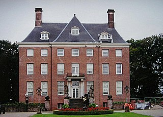
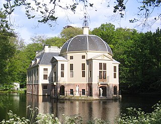
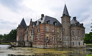
A buitenplaats was a summer residence for rich townspeople in the Netherlands. During the Dutch Golden Age of the 17th century, many traders and city administrators in Dutch towns became very wealthy. Many of them bought country estates, at first mainly to collect rents, however soon mansions started to be built there, which were used only during the summer.
Beerschoten is a hamlet in the municipality Utrechtse Heuvelrug, in the Dutch province Utrecht.
Breedeveen is a hamlet in the municipality Utrechtse Heuvelrug, in the Dutch province Utrecht. It lies in a forest north of the village of Leersum, on the road from Leersum to Woudenberg.
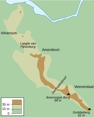
Utrecht Hill Ridge is a ridge of low sandhills that stretches in a direction from southeast to northwest over the Dutch province of Utrecht and over a part of North Holland. The total length of the region is about 50 km. It covers an area of approximately 23,000 hectares. The part of the ridge in North Holland is commonly called Het Gooi in Dutch, the Gooi (area) in English.
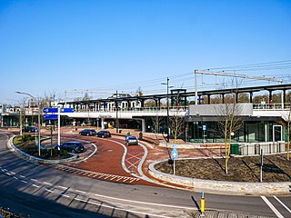
Driebergen-Zeist is a railway station located between Driebergen-Rijsenburg and Zeist, Netherlands. It is located in the municipality of Utrechtse Heuvelrug. The station was opened on 17 June 1844 and is located on the Amsterdam–Arnhem railway. The station is operated by Nederlandse Spoorwegen. In 2018 there were approximately 8,787 passengers per day using Driebergen-Zeist station. The station underwent a major uprade between 2017 and 2020 which provided additional bicycle parking and removed a nearby level crossing.
Utrechtse Heuvelrug National Park is a national park in the Dutch province of Utrecht. It covers the southern part of the Utrecht Hill Ridge. When it was founded in 2003, the park covered 6,000 ha of heathlands, shifting sands, forests, grass lands and floodplains. In 2013 the park was extended to 10,000 ha, adding the area north of highway A12 when the ecoduct Mollebos was realized. The most striking landscape feature is the glacial ridge after which the park is named.
Twickel is a protected historic country estate with 81 complex parts near Delden in the hamlet of Deldeneresch, in the municipality of Hof van Twente in the province of Overijssel in The Netherlands. The moated castle forms the center.
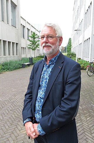
Dr Frans Vera is a Dutch biologist and conservationist. He has played a key part in devising the current ecological strategy for the Netherlands. He has hypothesised that Western European primeval forests at the end of the Pleistocene epoch did not consist only of "closed-canopy" high-forest conditions, but also included pastures combined with forests, a hypothesis variously addressed as the Vera hypothesis or the wood-pasture hypothesis.
This page is based on this Wikipedia article Text is available under the CC BY-SA 4.0 license; additional terms may apply. Images, videos and audio are available under their respective licenses.


