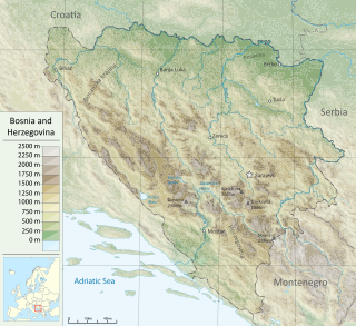
Bosnia and Herzegovina is located in Southeastern Europe. Situated in the western Balkans, it has a 932 km (579 mi) border with Croatia to the north and southwest, a 357 km (222 mi) border with Serbia to the east, and a 249 km (155 mi) border with Montenegro to the southeast. It borders the Adriatic Sea along its 20 km (12 mi) coastline.

The Sava is a river in Central and Southeast Europe, a right-bank and the longest tributary of the Danube. It flows through Slovenia, Croatia and along its border with Bosnia and Herzegovina, and finally through Serbia, feeding into the Danube in its capital, Belgrade. The Sava forms the main northern limit of the Balkan Peninsula, and the southern edge of the Pannonian Plain.

The Bosna is the third longest river in Bosnia and Herzegovina, and is considered one of the country's three major internal rivers, along with the Neretva and the Vrbas. The other three major rivers of Bosnia and Herzegovina are the Una, to the northwest; the Sava, to the north, and the Drina, to the east. This river is the namesake of Bosnia. The river Bosna flows for 282 kilometers (175 mi).

The huchen, also known as Danube salmon or redfish, is a large species of freshwater fish in the family Salmonidae native to the Danube basin in Central and Eastern Europe. It is the type species of genus Hucho, being closely related to salmon, trout, char and lenoks.
The Tara is a river in Montenegro and Bosnia and Herzegovina. It emerges from the confluence of the Opasnica and Veruša rivers in the Komovi Mountains, part of the Dinaric Alps of Montenegro. The total length is 143 km (89 mi), of which 141 km (88 mi) are in or on the border of Montenegro, it also forms the border between the two countries in several places. The Tara flows from south to north - north-west and converges with the Piva at the Bosnia and Herzegovina and Montenegro border between the villages of Šćepan Polje (Montenegro) and Hum to form the Drina river.

The Sava Dolinka is a headwater of the Sava River in northwestern Slovenia. The 45 kilometres (28 mi) long Sava Dolinka starts as Nadiža Creek in the Planica Valley under Mount Zadnja Ponca in the Julian Alps, at an elevation of 1222 m, close to the Italian border. The stream goes underground soon after its source and breaks out again after 5 km at an elevation of 842 m in Zelenci, near Kranjska Gora. The Sava Dolinka flows through Kranjska Gora, Gozd Martuljek, Jesenice, between Bled and Breg, and past the town of Lesce. The first in a series of hydroelectric power plants on the river, the Moste Hydro Power Plant, is located near Žirovnica. It merges with the second major headwater of the Sava, the Sava Bohinjka, at Radovljica. Tributaries of the Sava Dolinka include the Triglav Bistrica at Mojstrana and the Radovna, which flows through the Vintgar Gorge near Bled.
The Lim or Vermosh River is a river that flows through Albania, Montenegro, Serbia and Bosnia and Herzegovina and is 219 km (136 mi) long. It is also the right and the longest tributary of the Drina.

The Bosut is a river in the Syrmia region of eastern Croatia and northwestern Serbia. It is a 186 km long, slow and meandering left tributary of the Sava river.

The Ćehotina, also known as the Ćeotina, Ćotina or Čehotina, is a 125 kilometres (78 mi) long river in Montenegro and Bosnia and Herzegovina. It is a right bank tributary of the Drina river.

The Piva is a river in Montenegro and Bosnia and Herzegovina. The river runs through Montenegro for most of its course length, and in its last three kilometres marks the border between the two countries.
The Jerez is a river in western Serbia, a 56 km-long right tributary to the Sava river.

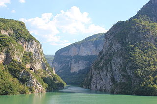
The Drina is a 346 km (215 mi) long river in the Balkans, which forms a large portion of the border between Bosnia and Herzegovina and Serbia. It is the longest tributary of the Sava River and the longest karst river in the Dinaric Alps which belongs to the Danube River drainage basin. Its name is derived from the Roman name of the river which in turn is derived from Greek which is derived from the native name of Illyrian origin.

The Sutjeska is a 35 km-long river in eastern Bosnia and Herzegovina. It is a tributary of the Drina river, which it meets south of Foča.

Posavina is a geographical region that stretches along the Sava river, encompassing only the inner areas of the Sava river basin, that are adjacent or near to the Sava river itself, namely catch region spanning from the Julian Alps in the northwest to the confluence with the Danube in the southeast. It passes through several countries of former Yugoslavia, namely Slovenia, Croatia, Bosnia and Herzegovina and Serbia. In Slovene, the term Posavina is not used to describe the parts of Slovenia that lie by the Sava river. Instead, the terms Posavje, Zasavje and Zgornjesavska dolina are used.

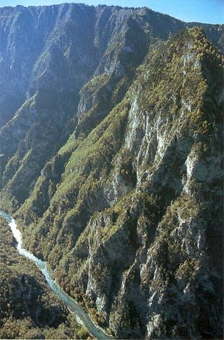
The Prača is a left tributary of the Drina in eastern Bosnia and Herzegovina. It source is in Pale, Bosnia and Herzegovina at an altitude of 1540 m. After 55 km it flows into the Drina in Ustiprača. The Prača Canyon is declared a nature monument and a protected landscape, including caves of Mračna Pećina and Govještica as Special geo-morphological reserves of Bosnia and Herzegovina.
Ukrina is a river in the Central Bosnia, Bosnia and Herzegovina, right tributary of the river Sava. Its mouth is 3 km north from settlement Koraće and 10 km southwest of Brod.
The Kravica is a short river in Bratunac, Republic of Srpska, Bosnia and Herzegovina. It is located in the Drina basin. The river starts in the Konjevići and flows into the Jadar river, a tributary of Drinjača, in Ježeštica.


