Fettercairn is a small village in Aberdeenshire, Scotland, northwest of Laurencekirk in Aberdeenshire on the B966 from Edzell. Fettercairn is also reached via the Cairn O' Mount road (B974) from Deeside.

Catterline is a coastal village on the North Sea in Aberdeenshire, Scotland. It is situated about 5 miles (8.0 km) south of Stonehaven; nearby to the north are Dunnottar Castle and Fowlsheugh Nature Reserve. Other noted architectural or historic features in the general area include Fetteresso Castle, Fiddes Castle, Chapel of St. Mary and St. Nathalan and Muchalls Castle.

Glenbervie is located in the north east of Scotland in the Howe o' the Mearns, one mile from the village of Drumlithie and eight miles south of Stonehaven in Aberdeenshire. The river Bervie runs through the village. The rural area is the location of Glenbervie House and estate. The parish was formerly named Overbervie.

Meikle Carewe Hill is a landform in Aberdeenshire, Scotland within the Mounth Range of the Grampian Mountains. The peak elevation of this mountain is 266 metres above mean sea level. Meikle Carewe is a prominent landform visible from a number of coastal hills such as Kempstone Hill and Megray Hill; it also forms a major backdrop to the community of Netherley.
Curlethney Hill is a landform in Aberdeenshire, Scotland within the Mounth Range of the Grampian Mountains. The peak elevation of this mountain is 246 metres above mean sea level. This landform lies slightly southwest of the village of Netherley. The northwest boundary of the moorland atop Curlethney Hill is formed by the southwestern flanks of Craggie Cat, a nearby peak.
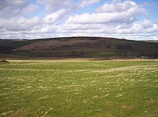
Kempstone Hill is a landform in Aberdeenshire, Scotland within the Mounth Range of the Grampian Mountains. The peak elevation of this mountain is 132 metres above mean sea level. This hill has been posited by Gabriel Jacques Surenne, Archibald Watt and C.Michael Hogan as the location for the noted Battle of Mons Graupius between the Romans and the indigenous Caledonians. The major Roman Camp of Raedykes is situated about three kilometres to the west. From Kempstone Hill there are fine views to the North Sea facing east and slightly to the north of Muchalls Castle. There is a UK trigpoint installation on Kempstone Hill.
Megray Hill is a low-lying coastal mountainous landform in Aberdeenshire, Scotland within the Mounth Range of the Grampian Mountains. The peak elevation of this mountain is 120 metres above mean sea level. This hill has been posited as a likely location for the noted Battle of Mons Graupius between the Romans and the indigenous Caledonians. The major Roman Camp of Raedykes is situated about three kilometres to the west. From Megray Hill there are expansive views to the North Sea facing east. The summit affords scenic vies of the historic harbour of Stonehaven.

Saddle Hill is a low lying mountain in eastern Aberdeenshire, Scotland within the Mounth Range of the Grampian Mountains. Its peak is 241 metres (791 ft) above mean sea level. This hill is immediately north of the Roman camp of Raedykes. From Saddle Hill there are expansive views to the North Sea facing east and the valley of the Burn of Monboys to the east and southeast.

Tullich is a village in Aberdeenshire, Scotland. It is known as the birthplace of St. Nathalan and also as the site of some noted Pictish stones.
Craggie Cat is a hill landform in the Mounth of the Grampian Mountains at the southern edge of Netherley, Aberdeenshire, Scotland. The peak elevation of Craggie Cat is 198 metres according to the Ordnance Survey. This hill's southwestern flanks form the northwest boundary of the moorland of Curlethney Hill.

Durris Forest is a chiefly coniferous forest south of the River Dee approximately three kilometres west of Netherley in Aberdeenshire, Scotland. The A957 road forms the southwest boundary of Durris Forest, separating it from Fetteresso Forest. The Durris Forest includes several smaller named woodlands. The ancient route of Elsick Mounth crosses the Grampian Mounth within the Durris Forest. Notable natural features in the vicinity include Red Moss and Meikle Carewe Hill. Notable historic features in this area include Raedykes Roman Camp, Muchalls Castle and Maryculter House.
Limpet Burn is a watercourse in Aberdeenshire, Scotland whose discharge is deemed part of the North Sea coastal drainage. Prominent geographic features in the vicinity of Limpet Burn are Megray Hill and Kempstone Hill. Notable buildings in proximity to Limpet Burn are Ury House, Muchalls Castle and Chapel of St. Mary and St. Nathalan. Part of the watershed of Limpet Burn has been suggested by some as the site of the first recorded battle in the history of Scotland, the Battle of Mons Graupius.
Red Cloak is an industrial area of Stonehaven, Aberdeenshire, Scotland. The site's settlement history is associated with events at the nearby Chapel of St. Mary and St. Nathalan. In current times Red Cloak is primarily an industrial dominated land use that includes Aberdeenshire Council recycling and refuse disposal functions. Earliest area prehistory is evidenced by Bronze Age finds at Fetteresso Castle and Ury House.
Garmond is a linear village in Monquhitter Parish which is located in Aberdeenshire, Scotland. It was founded c.1760. Like the neighbouring villages of Cuminestown and New Byth, the residential part is located on the crest of a hill, the valley below being largely given over to farmland.
Thornyhive Bay is an embayment along the North Sea coast in Aberdeenshire, Scotland. This bay is situated approximately 2.5 miles south of the town of Stonehaven and approximately 2.5 miles north of the Fowlsheugh Nature Reserve. The steep cliffs afford sightings of certain seabirds.
Bogjurgan Hill is an elevated landform at the southern verge of the Fetteresso Forest in Aberdeenshire, Scotland. Its top is at an elevation of 299 metres (981 ft) above sea level. Historical features in this region of Kincardineshire include Fetteresso Castle, Drumtochty Castle and Muchalls Castle.
The Burn of Myrehouse is a coastal stream in Aberdeenshire in northeast Scotland discharging to Banff Bay. This watercourse has been suggested as an associated feature to the prehistoric feature at nearby Longman Hill.

Banff Bay is a coastal embayment in Scotland situated between the towns of Banff, Aberdeenshire and Macduff, Aberdeenshire. The Burn of Myrehouse is one of the streams draining to Banff Bay. Banff Bay is a prominent geographical feature along the northern coast of Aberdeenshire, and it is visible from a number of locations along the coastal plain such as Longman Hill situated somewhat distant to the east.
Longman Hill is a Bronze Age long barrow situated atop a prominent rounded landform in northern Aberdeenshire, Scotland near Banff Bay. Due to the low-lying coastal plain characteristics, the elevation of Longman Hill affords a long-distance view as far as the Moray Firth.
Laeca Burn is a stream in northeastern Aberdeenshire, Scotland. There are numerous archaeological sites in the Laeca Burn watershed, "especially on the eastern side of Laeca Burn", where Catto Long Barrow is situated.