Borland Software Corporation was a computer technology company founded in 1983 by Niels Jensen, Ole Henriksen, Mogens Glad, and Philippe Kahn. Its main business was the development and sale of software development and software deployment products. Borland was first headquartered in Scotts Valley, California, then in Cupertino, California, and then in Austin, Texas. In 2009, the company became a full subsidiary of the British firm Micro Focus International plc.

Orienteering is a group of sports that involve using a map and compass to navigate from point to point in diverse and usually unfamiliar terrain whilst moving at speed. Participants are given a topographical map, usually a specially prepared orienteering map, which they use to find control points. Originally a training exercise in land navigation for military officers, orienteering has developed many variations. Among these, the oldest and the most popular is foot orienteering. For the purposes of this article, foot orienteering serves as a point of departure for discussion of all other variations, but almost any sport that involves racing against a clock and requires navigation with a map is a type of orienteering.

Environmental Systems Research Institute, Inc., doing business as Esri, is an American multinational geographic information system (GIS) software company headquartered in Redlands, California. It is best known for its ArcGIS products. With a 40% market share, Esri is the world's leading supplier of GIS software, web GIS and geodatabase management applications.

Drosera capillaris, also known as the pink sundew, is a species of carnivorous plant belonging to the family Droseraceae. It is native to the southern United States, the Greater Antilles, western and southern Mexico, Central America, and northern South America. It is listed as vulnerable in the US state of Virginia, and critically imperiled in Arkansas, Maryland, and Tennessee.

Amateur radio direction finding is an amateur racing sport that combines radio direction finding with the map and compass skills of orienteering. It is a timed race in which individual competitors use a topographic map, a magnetic compass and radio direction finding apparatus to navigate through diverse wooded terrain while searching for radio transmitters. The rules of the sport and international competitions are organized by the International Amateur Radio Union. The sport has been most popular in Eastern Europe, Russia, and China, where it was often used in the physical education programs in schools.

The International Orienteering Federation (IOF) is the international governing body of the sport of orienteering. The IOF head office is located in Karlstad, Sweden. The IOF governs four orienteering disciplines: foot orienteering, mountain bike orienteering, ski orienteering, and trail orienteering.
The comparison of mail servers covers mail transfer agents (MTAs), mail delivery agents, and other computer software that provide e-mail services.
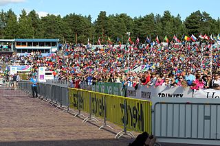
The World Orienteering Championships is an annual orienteering event organized by the International Orienteering Federation. The first World Championships was held in Fiskars, Finland in 1966. They were held biennially up to 2003. Since 2003, competitions have been held annually. Participating nations have to be members of the International Orienteering Federation (IOF).
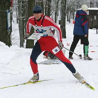
Ski orienteering (SkiO) is a cross-country skiing endurance winter racing sport and one of the four orienteering disciplines recognized by the IOF. A successful ski orienteer combines high physical endurance, strength and excellent technical skiing skills with the ability to navigate and make the best route choices while skiing at a high speed.
The World Ski Orienteering Championships (Ski-WOC) is the official event to award the titles of World Champions in ski orienteering. The World Championships is organized every odd year. The programme includes Sprint, Middle and Long Distance competitions, and a Relay for both men and women. The first Ski-WOC was held in 1975.
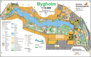
An orienteering map is a map specially prepared for use in orienteering events. It is a large-scale topographic map with extra markings to help the participant navigate through the course.

Søren Bobach is a Danish orienteering competitor, and world champion at both junior and senior level. He runs for OK Pan Århus.
The history of orienteering begins in the late 19th century in Sweden, where it originated as military training. The actual term "orienteering" was first used in 1886 at the Swedish Military Academy Karlberg and meant the crossing of unknown land with the aid of a map and a compass. The competitive sport began when the first competition was held for Swedish military officers on 28 May 1893 at the yearly games of the Stockholm garrison. The first civilian competition, in Norway on 31 October 1897, was sponsored by the Tjalve Sports Club and held near Oslo. The course was long by modern standards, at 19.5 km, on which only three controls were placed. The competition was won by Peder Fossum in a time of 1 hour, 47 minutes, and 7 seconds.
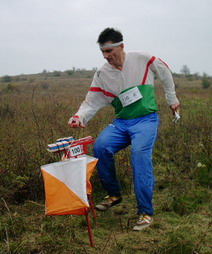
A control point is a marked waypoint used in orienteering and related sports such as rogaining and adventure racing. It is located in the competition area; marked both on an orienteering map and in the terrain, and described on a control description sheet. The control point must be identifiable on the map and on the ground. A control point has three components: a high visibility item, known as a flag or kite; an identifier, known as a control code; and a recording mechanism for contestants to record proof that they visited the control point. The control point is usually temporary, except on a permanent orienteering course.

An orienteering course is composed of a start point, a series of control points, and a finish point. Controls are marked with a white and orange flag in the terrain, and corresponding purple symbols on an orienteering map. The challenge is to complete the course by visiting all control points in the shortest possible time, aided only by the map and a compass.

In computer science, Orfeo Toolbox (OTB) is a software library for processing images from Earth observation satellites.
Underwater orienteering is an underwater sport that uses recreational open circuit scuba diving equipment and consists of a set of individual and team events conducted in both sheltered and open water testing the competitors' competency in underwater navigation. The competition is principally concerned with the effectiveness of navigation technique used by competitors to swim an underwater course following a route marked on a map prepared by the competition organisers, a compass and a counter meter to measure the distance covered. The sport was developed in the Soviet Union during the late 1950s and is played mainly in Europe. It is known as Orientation Sub in French and as La Orientación Subacuática in Spanish. Historically, the sport has also been known as Technical Disciplines.
The World Trail Orienteering Championships (WTOC) were first held in 2004 and annually since them. The majority of the championships have been held in Europe, with 2005 the only exception to date.
The World Masters Orienteering Championships (WMOC) (formerly the Veteran World Cup) is an annual orienteering competition organized by the International Orienteering Federation (IOF).

