
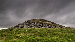
A chambered cairn is a burial monument, usually constructed during the Neolithic, consisting of a sizeable chamber around and over which a cairn of stones was constructed. Some chambered cairns are also passage-graves. They are found throughout Britain and Ireland, with the largest number in Scotland.

In archaeology, a tell is an artificial topographical feature, a mound consisting of the accumulated and stratified debris of a succession of consecutive settlements at the same site, the refuse of generations of people who built and inhabited them and natural sediment.

A henge loosely describes one of three related types of Neolithic earthwork. The essential characteristic of all three is that they feature a ring-shaped bank and ditch, with the ditch inside the bank. Because the internal ditches would have served defensive purposes poorly, henges are not considered to have been defensive constructions. The three henge types are as follows, with the figure in brackets being the approximate diameter of the central flat area:
- Henge. The word henge refers to a particular type of earthwork of the Neolithic period, typically consisting of a roughly circular or oval-shaped bank with an internal ditch surrounding a central flat area of more than 20 m (66 ft) in diameter. There is typically little if any evidence of occupation in a henge, although they may contain ritual structures such as stone circles, timber circles and coves. Henge monument is sometimes used as a synonym for henge. Henges sometimes, but by no means always, featured stone or timber circles, and circle henge is sometimes used to describe these structures. The three largest stone circles in Britain are each within a henge. Examples of henges without significant internal monuments are the three henges of Thornborough Henges. Although having given its name to the word henge, Stonehenge is atypical in that the ditch is outside the main earthwork bank.
- Hengiform monument. Like an ordinary henge, except the central flat area is between 5 and 20 m (16–66 ft) in diameter, they comprise a modest earthwork with a fairly wide outer bank. The terms mini-henge or Dorchester henge are sometimes used as synonyms for hengiform monument. An example is the Neolithic site at Wormy Hillock Henge.
- Henge enclosure. A Neolithic ring earthwork with the ditch inside the bank, with the central flat area having abundant evidence of occupation and usually being more than 300 m (980 ft) in diameter. Some true henges are as large as this, but lack evidence of domestic occupation. Super-henge or superhenge is sometimes used as a synonym for a henge enclosure. However, sometimes the term is used to indicate size alone rather than use, e.g. "Marden henge ... is the least understood of the four British 'superhenges' ".

Durrington Walls is the site of a large Neolithic settlement and later henge enclosure located in the Stonehenge World Heritage Site in England. It lies 2 miles (3.2 km) north-east of Stonehenge in the parish of Durrington, just north of Amesbury in Wiltshire. The henge is the second-largest Late Neolithic palisaded enclosure known in the United Kingdom, after Hindwell in Wales.
Combe Hill is a causewayed enclosure, near Eastbourne in East Sussex, on the northern edge of the South Downs. It consists of an inner circuit of ditches and banks, incomplete where it meets a steep slope on its north side, and the remains of an outer circuit. Causewayed enclosures were built in England from shortly before 3700 BC until at least 3500 BC; they are characterized by the full or partial enclosure of an area with ditches that are interrupted by gaps, or causeways. Their purpose is not known; they may have been settlements, meeting places, or ritual sites. The historian Hadrian Allcroft included the site in his 1908 book Earthwork of England, and in 1930 E. Cecil Curwen listed it as a possible Neolithic site in a paper which attempted to provide the first list of all the causewayed enclosures in England.

In archaeology, an enclosure is one of the most common types of archaeological site – It is any area of land separated from surrounding land by earthworks, walls or fencing. Such a simple feature is found all over the world and during almost all archaeological periods. They may be few metres across or be large enough to encompass whole cities.
Dunragit is a village on the A75, between Stranraer and Glenluce in Dumfries and Galloway, south-west Scotland. Dunragit is within the parish of Old Luce, in the traditional county of Wigtownshire. The modern village grew up around the west gate of Dunragit House, an 18th-century country house, though there is evidence of Neolithic settlement in the area.

Figsbury Ring is an 11.2 hectare biological Site of Special Scientific Interest in Wiltshire, England, notified in 1975. It is owned and managed by the National Trust.

In archaeology, earthworks are artificial changes in land level, typically made from piles of artificially placed or sculpted rocks and soil. Earthworks can themselves be archaeological features, or they can show features beneath the surface.
Tapeh Yahya is an archaeological site in Kermān Province, Iran, some 220 kilometres (140 mi) south of Kerman city, 90 kilometres (56 mi) south of Baft city and 90 km south-west of Jiroft. The easternmost occupation of the Proto-Elamite culture was found there.
C. Joshua Pollard is a British archaeologist who is a professor of archaeology at the University of Southampton. He gained his BA and PhD in archaeology from the Cardiff University, and is a specialist in the archaeology of the Neolithic period in the UK and north-west Europe, especially in relation to the study of depositional practices, monumentality, and landscape. He is a Fellow of the Society of Antiquaries of London
Julian Stewart Thomas is a British archaeologist, publishing on the Neolithic and Bronze Age prehistory of Britain and north-west Europe. Thomas has been vice president of the Royal Anthropological Institute since 2007. He has been Professor of Archaeology at the University of Manchester since 2000, and is former secretary of the World Archaeological Congress. Thomas is perhaps best known as the author of the academic publication Understanding the Neolithic in particular, and for his work with the Stonehenge Riverside Project.
Timothy Darvill OBE was an English archaeologist and author, best known for his publications on prehistoric Britain and his excavations in England, Wales, and the Isle of Man. He was Professor of Archaeology in the Faculty of Science and Technology Bournemouth University in England. In April 2008 he co-directed excavations within Stonehenge, together with Geoffrey Wainwright and Miles Russell, to examine the early stone structures on the site. The work featured heavily in a BBC Timewatch programme which examined the theory that Stonehenge was a prehistoric centre of healing. He was appointed Officer of the Order of the British Empire (OBE) in the 2010 Queen's Birthday Honours for services to archaeology.
Old Luce is a civil parish in Dumfries and Galloway, Scotland. It lies in the Machars peninsula, in the traditional county of Wigtownshire. The parish is around 10 miles (16 km) long and 8 miles (13 km) broad, and contains 40,350 acres (16,330 ha).
Pict's Knowe is a henge monument in the parish of Troqueer, Dumfries and Galloway. It is one of a small group of henge monuments around Dumfries which includes Broadlea henge near Annan. Pict's Knowe is located 4 km SW of Dumfries on a small sandy bank in the peat covered valley of the Crooks Pow stream.
Curriestanes cursus is a large neolithic ditched enclosure on the outskirts of Dumfries, in the parish of Troqueer, Dumfries and Galloway. It is visible only from aerial photography. It is, along with Pict's Knowe, one of two scheduled monuments in Troqueer parish.

Maelmin Henge is modern interpretation/reconstruction of a henge monument near the village of Milfield, Northumberland in the Till Valley.
Mid Gleniron is a prehistoric site in Dumfries and Galloway used in the Neolithic and Bronze Age. The site is a scheduled ancient monument that comprises a group of six burial cairns. Two of the cairns, Mid Gleniron I and Mid Gleniron II are chambered cairns of the Clyde tradition. These are of historic importance because of their multi-stage construction which provides evidence for the development of Clyde cairns at the beginning of the Neolithic period.
A causewayed enclosure was found at Abingdon in Oxfordshire in 1926. Causewayed enclosures are a form of early Neolithic earthwork found in northwestern Europe; they were built in England from shortly before 3700 BC until about 3300 BC and are characterized by the full or partial enclosure of an area with ditches that are interrupted by gaps, or causeways. Their purpose is not known; they may have been settlements, or meeting places, or ritual sites.

Hopewell Ceremonial Earthworks is a World Heritage Site in the United States preserving eight monumental earthworks constructed by the Hopewell Culture. The sites consist of large geometric shapes covering several acres in area. Constructed between approximately 0 and 400 AD, the earthworks lie along tributaries of the Ohio River in the present-day state of Ohio. They depict the richness and depth of pre-Columbian culture, science, astronomy, and sacred monumental architecture. Many sites were plowed and reduced in size during almost 200 years of agricultural use.

