
Drumheller is a town on the Red Deer River in the badlands of east-central Alberta, Canada. It is located 110 kilometres (68 mi) northeast of Calgary and 97 kilometres (60 mi) south of Stettler. The Drumheller portion of the Red Deer River valley, often referred to as Dinosaur Valley, has an approximate width of 2 kilometres (1.2 mi) and an approximate length of 28 kilometres (17 mi).

Cougar is an unincorporated community and former town in Cowlitz County, Washington. Cougar is located around 30 miles (48 km) northeast of Woodland along Washington State Route 503 and situated along the northwest bank of Yale Lake, a reservoir on the Lewis River. The population of Cougar was 122 at the 1990 Census, when it was still incorporated as a town, but disincorporated before the 2000 Census. As of 2023, the population is 83. The Cougar community is part of the Woodland School District, a K-12 school district of about 2,200 students. Cougar is the nearest community to Mount St. Helens, which lies 13 miles (20.9215 km) to its northeast. The eruption of Mount St. Helens on May 18, 1980 was the deadliest and most economically destructive volcanic event in the history of the United States.

Cereal is a hamlet within Special Area No. 3 in central Alberta, Canada. It is approximately 161 km (100 mi) east of Drumheller. It was named after the post office that was established in the area in 1910. The name of the post office alluded to grain fields near the community. Cereal held village status prior to 2021.

Alberta Provincial Highway No. 10, commonly referred to as Highway 10, is a 22 km (14 mi) highway in southern Alberta, Canada that forms a part of Hoo Doo Trail. It is located wholly within the Town of Drumheller as a result of the former City of Drumheller's amalgamation with the Municipal District of Badlands No. 7 on January 1, 1998. It begins at Highway 9 in the heart of Drumheller and extends southeast along the Red Deer River where it passes through Rosedale, then crosses Highway 56 and travels through East Coulee. It ends by splitting off into Highways 570, 564, and 569.
Tyler Scott Drumheller was an American Central Intelligence Agency (CIA) officer who served during the Cold War and early War on Terror, advancing to chief of the European division for clandestine operations in the Directorate of Operations from 2001 until his retirement in 2005. He later became known for exposing the Bush White House's use of intelligence from Curveball, an unreliable Iraqi intelligence source managed by the German BND, to mislead policymakers and the public in the lead up to the 2003 invasion of Iraq.
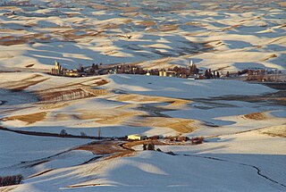
Steptoe is a small unincorporated rural town in Whitman County, Washington, United States. The ZIP Code for Steptoe is 99111.
Baird is a ghost town in Douglas County, Washington, United States. Baird is part of ZIP code 99115 and is home to the Highland Cemetery. Baird appears on a 1909 map of Douglas County. The town was located about 7 miles (11 km) west of Coulee City, on the high ground between Moses Coulee and Grand Coulee.
Laurier is a census-designated place in Ferry County, Washington that neighbors the Canada–United States border. The nearest school district is Orient School District. According to the 2010 census, Laurier had one permanent resident.
Harris is an unincorporated community in Elkins Township, Washington County, Arkansas, United States. It is located east of Fayetteville and within the city limits of Elkins near Arkansas Highway 16.

Barneston is an extinct town in King County, in the U.S. state of Washington. The GNIS classifies it as a populated place.

Buckeye is an unincorporated community in Spokane County, in the U.S. state of Washington.
Cromwell is an unincorporated community in Pierce County, in the U.S. state of Washington.
Edgewick is an unincorporated community in King County, in the U.S. state of Washington.
Ehrlich is an extinct town in Skagit County, in the U.S. state of Washington.
Getchell is an unincorporated community in Snohomish County, in the U.S. state of Washington.
Glencove is an unincorporated community in Pierce County, in the U.S. state of Washington.

Hazard is an unincorporated community in Spokane County, in the U.S. state of Washington.
Lindberg is an extinct town in Lewis County, in the U.S. state of Washington. The GNIS lists location as unknown, however period maps show Lindberg on State Route 7, about three miles north of the U.S. Route 12 junction, where the East Fork Tilton River joins Tilton River.
Anthonies Mill is an unincorporated community in Washington County, in the U.S. state of Missouri. The community is located at the confluence of Ashley Branch with Brazil Creek on the western border of the county. The site is at the junction of routes N and W. The old community of Vilander lies in Crawford County just 2.5 miles downstream to the west.
Aptus is an unincorporated community in Washington County, in the U.S. state of Missouri. The community is located approximately eight miles northwest of Potosi on Missouri Route F just north of the confluence of Rogue Creek with Mineral Fork.


