
Drumheller is a town within the Red Deer River valley in the badlands of east-central Alberta, Canada. It is located 110 kilometres (68 mi) northeast of Calgary, and 97 kilometres (60 mi) south of Stettler. The Drumheller portion of the Red Deer River valley, often referred to as Dinosaur Valley, has an approximate width of 2 kilometres (1.2 mi) and an approximate length of 28 kilometres (17 mi).

The Royal Tyrrell Museum of Palaeontology (RTMP) is a palaeontology museum and research facility in Drumheller, Alberta, Canada. The museum is situated within a 12,500-square-metre-building (135,000 sq ft) designed by BCW Architects at Midland Provincial Park.

Drumheller-Stettler is a provincial electoral district (riding) in Alberta, Canada. The electoral district is mandated to return a single member to the Legislative Assembly of Alberta using the first past the post method of voting. The district was created in the 2003 boundary redistribution and came into force in 2004 from the old districts of Drumheller-Chinook and Lacombe-Stettler.

The Red Deer River is a river in Alberta and a small portion of Saskatchewan, Canada. It is a major tributary of the South Saskatchewan River and is part of the larger Saskatchewan-Nelson system that empties into Hudson Bay.

Big Valley is a village in central Alberta south east of Red Deer. It is located 32 km (20 mi) south of Stettler and 64 km (40 mi) north of Drumheller on Highway 56 in the County of Stettler No. 6.

Carbon is a village in central Alberta, Canada.

Alberta Provincial Highway No. 9, commonly referred to as Highway 9, is a highway in south-central Alberta, Canada, which together with Saskatchewan Highway 7 connects Calgary to Saskatoon, Saskatchewan via Drumheller. It is designated as a core route of the National Highway System, forming a portion of an interprovincial corridor. Highway 9 spans approximately 324 km (201 mi) from the Trans-Canada Highway east of Calgary to Alberta's border with Saskatchewan.

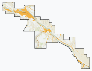
Alberta Provincial Highway No. 10, commonly referred to as Highway 10, is a 22 km (14 mi) highway in southern Alberta, Canada that forms a part of Hoo Doo Trail. It is located wholly within the Town of Drumheller as a result of the former City of Drumheller's amalgamation with the Municipal District of Badlands No. 7 on January 1, 1998. It begins at Highway 9 in the heart of Drumheller and extends southeast along the Red Deer River where it passes through Rosedale, then crosses Highway 56 and travels through East Coulee. It ends by splitting off into Highways 570, 564, and 569.
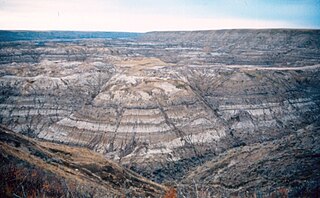
The Horseshoe Canyon Formation is a stratigraphic unit of the Western Canada Sedimentary Basin in southwestern Alberta. It takes its name from Horseshoe Canyon, an area of badlands near Drumheller.

Midland Provincial Park is a provincial park located in Alberta, Canada.
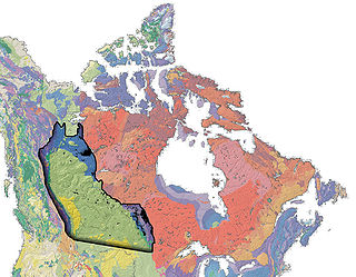
The Western Canada Sedimentary Basin (WCSB) is a vast sedimentary basin underlying 1,400,000 square kilometres (540,000 sq mi) of Western Canada including southwestern Manitoba, southern Saskatchewan, Alberta, northeastern British Columbia and the southwest corner of the Northwest Territories. It consists of a massive wedge of sedimentary rock extending from the Rocky Mountains in the west to the Canadian Shield in the east. This wedge is about 6 kilometres (3.7 mi) thick under the Rocky Mountains, but thins to zero at its eastern margins. The WCSB contains one of the world's largest reserves of petroleum and natural gas and supplies much of the North American market, producing more than 16,000,000,000 cubic feet (450,000,000 m3) per day of gas in 2000. It also has huge reserves of coal. Of the provinces and territories within the WCSB, Alberta has most of the oil and gas reserves and almost all of the oil sands.

Rosebud, Alberta is a hamlet in southern Alberta, Canada within Wheatland County. Previously an incorporated municipality, Rosebud dissolved from village status on January 1, 1946 to become part of the Municipal District of Grasswold No. 248.

The Atlas Coal Mine National Historic Site is an inactive coal mine in Alberta, Canada that operated from 1936 to 1979. Located in East Coulee, it is considered to be Canada's most complete historic coal mine and is home to the country's last standing wooden coal tipple, and the largest still standing in North America. It was designated an Alberta Provincial Historic Resource in 1989 and a National Historic Site of Canada in 2002.
East Coulee is a community within the Town of Drumheller, Alberta, Canada. It was previously a hamlet within the former Municipal District (MD) of Badlands No. 7 prior to the MD's amalgamation with the former City of Drumheller on January 1, 1998. It is also recognized as a designated place by Statistics Canada.
Nacmine is a community within the Town of Drumheller, Alberta, Canada. It was previously a hamlet within the former Municipal District (MD) of Badlands No. 7 prior to the MD's amalgamation with the former City of Drumheller on January 1, 1998.

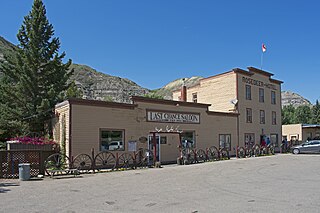
Rosedale is a community within the Town of Drumheller, Alberta, Canada. It was previously a hamlet within the former Municipal District (MD) of Badlands No. 7 prior to the MD's amalgamation with the former City of Drumheller on January 1, 1998. It is also recognized as a designated place by Statistics Canada.
Wayne is a community within the Town of Drumheller, Alberta, Canada. It was previously a hamlet within the former Municipal District (MD) of Badlands No. 7 prior to the MD's amalgamation with the former City of Drumheller on January 1, 1998.
Midlandvale is a community within the Town of Drumheller, Alberta, Canada. It was previously a hamlet within the former Municipal District of Badlands No. 7 prior to being annexed by Drumheller in 1972. Now referred to as Midland by the Town of Drumheller, the community is located within the Red Deer River valley on North Dinosaur Trail, approximately 3 km (1.9 mi) west of Drumheller's main townsite.
Newcastle is a community within the Town of Drumheller, Alberta, Canada. It held village status for eight years between 1923 and 1931, and was recognized as a hamlet prior to annexation by Drumheller in 1967. The community is located within the Red Deer River valley on South Dinosaur Trail, approximately 2 km (1.2 mi) west of Drumheller's main townsite. The former hamlet of Midlandvale is located across the river to the north.