
A flood is an overflow of water that submerges land that is usually dry. In the sense of "flowing water", the word may also be applied to the inflow of the tide. Floods are an area of study of the discipline hydrology and are of significant concern in agriculture, civil engineering and public health. Human changes to the environment often increase the intensity and frequency of flooding, for example land use changes such as deforestation and removal of wetlands, changes in waterway course or flood controls such as with levees, and larger environmental issues such as climate change and sea level rise. In particular climate change's increased rainfall and extreme weather events increases the severity of other causes for flooding, resulting in more intense floods and increased flood risk.

The Santa Clara River is an 83 mi (134 km) long river in Southern California. It drains parts of four ranges in the Transverse Ranges System north and northwest of Los Angeles, then flows west onto the Oxnard Plain and into the Santa Barbara Channel of the Pacific Ocean.

The Great Miami River is a tributary of the Ohio River, approximately 160 miles (260 km) long, in southwestern Ohio and Indiana in the United States. The Great Miami originates at the man-made Indian Lake and flows south through the cities of Sidney, Piqua, Troy, Dayton, Middletown and Hamilton.

The Stillwater River is a 69.3-mile-long (111.5 km) tributary of the Great Miami River in western Ohio in the United States. Via the Great Miami and Ohio rivers, it is part of the Mississippi River watershed.

Seven Oaks Dam is a 550-foot (170 m) high earth and rock fill embankment dam across the Santa Ana River in the San Bernardino Mountains, about 4 miles (6.4 km) northeast of Redlands in San Bernardino County, southern California. It impounds Seven Oaks Reservoir in the San Bernardino National Forest.

Arthur Ernest Morgan was a civil engineer, U.S. administrator, and educator. He was the design engineer for the Miami Conservancy District flood control system and oversaw construction. He served as the president of Antioch College between 1920 and 1936. He was also the first chairman of Tennessee Valley Authority from 1933 until 1938 in which he used the concepts proven in his earlier work with the Miami Conservancy District.

The Miami Conservancy District is a river management agency operating in Southwest Ohio to control flooding of the Great Miami River and its tributaries. It was organized in 1915 following the catastrophic Great Dayton Flood of the Great Miami River in March 1913, which hit Dayton, Ohio particularly hard. Designed by Arthur Ernest Morgan, the Miami Conservancy District built levees, straightened the river channel throughout the Miami Valley, and built five dry dams on various tributaries to control flooding. The district and its projects are unusual in that they were funded almost entirely by local tax initiatives, unlike similar projects elsewhere which were funded by the federal government and coordinated by the U.S. Army Corps of Engineers.
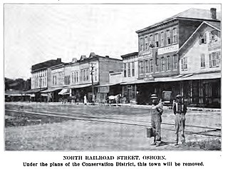
Osborn was a town located near the Haddix Road-Ohio 235 intersection at the northern edge of Wright-Patterson Air Force Base in what is now the flood-prone basin of the Huffman Dam in the U.S. state of Ohio.

The Mokelumne River is a 95-mile (153 km)-long river in northern California in the United States. The river flows west from a rugged portion of the central Sierra Nevada into the Central Valley and ultimately the Sacramento–San Joaquin River Delta, where it empties into the San Joaquin River-Stockton Deepwater Shipping Channel. Together with its main tributary, the Cosumnes River, the Mokelumne drains 2,143 square miles (5,550 km2) in parts of five California counties. Measured to its farthest source at the head of the North Fork, the river stretches for 157 miles (253 km).

Cache Creek is an 87-mile-long (140 km) stream in Lake, Colusa and Yolo counties, California.

The Great Dayton Flood of 1913 resulted from flooding by the Great Miami River reaching Dayton, Ohio, and the surrounding area, causing the greatest natural disaster in Ohio history. In response, the General Assembly passed the Vonderheide Act to enable the formation of conservancy districts. The Miami Conservancy District, which included Dayton and the surrounding area, became one of the first major flood control districts in Ohio and the United States.

Mohawk Dam, located in Jefferson Township, Coshocton County, Ohio northwest of Nellie, is a dry dam constructed by the United States Army Corps of Engineers (USACE) in the mid-1930s for the purpose of flood control on the Walhonding River. The dam is part of the larger 18-county Muskingum Watershed Conservancy District (MWCD). The dam has been in service for 70 years and was recently placed on the USACE's "Urgent" dam safety classification list and plans are currently being drafted that would allocate funds for dam stabilization.

Senecaville Lake is a reservoir in Guernsey and Noble Counties, Ohio. It is located approximately 13 miles (21 km) southeast of Cambridge near the village of Senecaville, Ohio. The lake is popular among recreation and fishing enthusiasts. It is often referred to locally as Seneca Lake.
The Muskingum Watershed Conservancy District (MWCD) is a political subdivision of the State of Ohio organized in 1933 to develop and implement a plan for flood reduction and water conservation in the Muskingum River watershed, the state's largest wholly contained watershed, covering more than 8,000 square miles (21,000 km2). Since the original construction of fourteen reservoirs and dams in the 1930s, more than $7 billion worth of property damage has been saved from flooding.

Flood control methods are used to reduce or prevent the detrimental effects of flood waters. Flood relief methods are used to reduce the effects of flood waters or high water levels. Flooding can be caused by a mix of both natural processes, such as extreme weather upstream, and human changes to waterbodies and runoff. Though building hard infrastructure to prevent flooding, such as flood walls, can be effective at managing flooding, increased best practice within landscape engineering is to rely more on soft infrastructure and natural systems, such as marshes and flood plains, for handling the increase in water. For flooding on coasts, coastal management practices have to not only handle changes water flow, but also natural processes like tides.
Flood Control Act of 1939Pub.L. 76–396, enacted on August 11, 1939, by the 76th Congress, is U.S. legislation that authorized construction of flood control projects across the United States. The passage of FCA 1939, authorized the transfer of ownership of the local and state dams to the United States Army Corps of Engineers.
Blackwater Dam is a dam in the town of Webster, Merrimack County, New Hampshire.

The Middle Rio Grande Conservancy District (MRGCD) was formed in 1925 to manage the irrigation systems and control floods in the Albuquerque Basin. It is responsible for the stretch of river from the Cochiti Dam in Sandoval County in the north, through Bernalillo County, Valencia County and Socorro County to the Elephant Butte Reservoir in the south. It manages the Angostura, Isleta and San Acacia diversion dams, which feed an extensive network of irrigation canals and ditches.

The Middle Rio Grande Project manages water in the Albuquerque Basin of New Mexico, United States. It includes major upgrades and extensions to the irrigation facilities built by the Middle Rio Grande Conservancy District and modifications to the channel of the Rio Grande to control sedimentation and flooding. The bulk of the work was done by the United States Bureau of Reclamation and the United States Army Corps of Engineers in the 1950s, but construction continued into the 1970s and maintenance is ongoing. The project is complementary to the San Juan-Chama Project, which transfers water from the San Juan River in the Colorado River Basin to the Rio Grande. Although distribution of water from the two projects is handled through separate allotments and contracts, there is some sharing of facilities including the river itself. The ecological impact on the river and the riparian zone was the subject of extended litigation after a group of environmentalists filed Rio Grande Silvery Minnow v. Bureau of Reclamation in 1999.

San Dimas Dam is a concrete gravity dam in Los Angeles County, California. The dam and its flood control basin/reservoir are in the San Gabriel Mountains and within the Angeles National Forest. The dam is currently operated by the Los Angeles County Department of Public Works but was originally built by the Los Angeles County Flood Control District in 1922. The dam controls flooding from San Dimas Creek, a major San Gabriel Mountains drainage and tributary of the San Gabriel River. As a flood control facility the San Dimas Reservoir is dry for most of the year, only storing water after significant winter storms. The regulation provided by the dam allows for the efficient diversion of floodwaters from San Dimas Wash to Puddingstone Reservoir, which protects the San Dimas area of the San Gabriel Valley.
