Related Research Articles

Carbon County is a county located in the U.S. state of Montana. As of the 2020 census, the population was 10,473. Its county seat is Red Lodge.

Big Horn County is a county located in the U.S. state of Montana. As of the 2020 census, the population was 13,124. The county seat is Hardin. The county, like the river and the mountain range, is named after the bighorn sheep in the Rocky Mountains. The county was founded in 1913. It is located on the south line of the state.
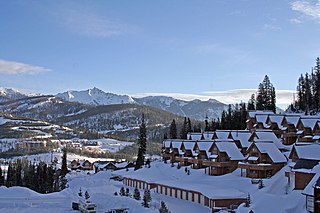
Big Sky is an unincorporated census-designated place (CDP) in Gallatin and Madison counties in southwestern Montana, United States. As of the 2010 census it had a population of 2,308. It is 45 miles (72 km) southwest of Bozeman. This unincorporated community straddles both counties, is not considered a town, and does not have a town government. The primary industry of the area is tourism.

Bighorn Canyon National Recreation Area is a national recreation area established by an act of Congress on October 15, 1966, following the construction of the Yellowtail Dam by the Bureau of Reclamation. It is one of over 420 sites managed by the U.S. National Park Service. The recreation area spans 120,296.22 acres, straddling the border between Wyoming and Montana. It is divided into two distinct areas, the North District accessed via Fort Smith, Montana and the South District accessed through Lovell, Wyoming. There is no thru road inside the recreation area connecting the two districts. The Yellowtail Dam is located in the North District. It is named after the famous Crow leader Robert Yellowtail, harnesses the waters of the Bighorn River by turning that variable watercourse into Bighorn Lake. The lake extends 71 miles (114 km) through Wyoming and Montana, 55 miles (89 km) of which lie within the national recreation area. The lake provides recreational boating, fishing, water skiing, kayaking, and birding opportunities to visitors. About one third of the park unit is located on the Crow Indian Reservation. Nearly one-quarter of the Pryor Mountains Wild Horse Range lies within the Bighorn Canyon National Recreation Area.
The Bighorn River is a tributary of the Yellowstone, approximately 461 miles (742 km) long, in the states of Wyoming and Montana in the western United States. The river was named in 1805 by fur trader François Larocque for the bighorn sheep he saw along its banks as he explored the Yellowstone.

The Little Bighorn River is a 138-mile-long (222 km) tributary of the Bighorn River in the United States in the states of Montana and Wyoming. The Battle of the Little Bighorn, also known as the Battle of the Greasy Grass, was fought on its banks on June 25–26, 1876, as well as the Battle of Crow Agency in 1887.

The Bighorn Mountains are a mountain range in northern Wyoming and southern Montana in the United States, forming a northwest-trending spur from the Rocky Mountains extending approximately 200 mi (320 km) northward on the Great Plains. They are separated from the Absaroka Range, which lie on the main branch of the Rockies to the west, by the Bighorn Basin. Much of the land is contained within the Bighorn National Forest.

The Bighorn Basin is a plateau region and intermontane basin, approximately 100 miles (160 km) wide, in north-central Wyoming in the United States. It is bounded by the Absaroka Range on the west, the Pryor Mountains on the north, the Bighorn Mountains on the east, and the Owl Creek Mountains and Bridger Mountains on the south. It is drained to the north by tributaries of the Bighorn River, which enters the basin from the south, through a gap between the Owl Creek and Bridger Mountains, as the Wind River, and becomes the Bighorn as it enters the basin. The region is semi-arid, receiving only 6–10 in (15–25 cm) of rain annually.

The Crow Indian Reservation is the homeland of the Crow Tribe. Established 1868, the reservation is located in parts of Big Horn, Yellowstone, and Treasure counties in southern Montana in the United States. The Crow Tribe has an enrolled membership of approximately 11,000, of whom 7,900 reside in the reservation. 20% speak Crow as their first language.
Kane is a ghost town that existed 2 miles (3.2 km) south of the confluence of the Shoshone River and the Bighorn River in Big Horn County, northern Wyoming, United States.

The Bridger Trail, also known as the Bridger Road and Bridger Immigrant Road, was an overland route connecting the Oregon Trail to the gold fields of Montana. Gold was discovered in Virginia City, Montana in 1863, prompting settlers and prospectors to find a trail to travel from central Wyoming to Montana. In 1863, John Bozeman and John Jacobs scouted the Bozeman Trail, which was a direct route to the Montana gold fields through the Powder River Country. At the time the region was controlled by the Sioux, Cheyenne and Arapaho, who stepped up their raids in response to the stream of settlers along the trail.
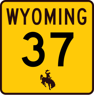
Wyoming Highway 37 is a 9-mile-long (14 km) north–south Wyoming state highway located in northern Big Horn County and travels from U.S. Route 14A north into Bighorn Canyon National Recreation Area.

The Pryor Mountains are a mountain range in Carbon and Big Horn counties of Montana, and Big Horn County, Wyoming. They are located on the Crow Indian Reservation and the Custer National Forest, and portions of them are on private land. They lie south of Billings, Montana, and north of Lovell, Wyoming.
The Bad Pass Trail, also known as the Sioux Trail, was established by Native Americans on the border of present-day Montana and Wyoming as a means of access from the Bighorn Basin in Wyoming to Bison-hunting grounds in the Grapevine Creek area of Montana. Marked by stone cairns, the trail led across Bad Pass and was established in pre-Columbian times. After Europeans arrived in the area it was frequented by fur trappers and mountain men, beginning in 1824. Trappers assembled pack trains at the junction of the Shoshone River and the Bighorn River, using the Bad Pass Trail to avoid Bighorn Canyon. The trail ended at the mouth of Grapevine Creek on the Bighorn, from which the pack train could float down the Bighorn on rafts to the Yellowstone River and then to the Missouri and on to St. Louis.

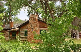
The M L Ranch was established by Henry Clay Lovell and his financial backer Anthony Mason in Wyoming's Big Horn Basin in the late 1870s to the south of the present location. The second and final location was established farther north as a cattle line camp in 1883 to be closer to markets in Billings, Montana. In 1884 it became the headquarters for a ranch that reached 25,000 acres (10,000 ha) in area. The bad winter of 1886–87 killed half the livestock on the ranch, more than 10,000 head., but the M L fared better than most. Mason died in 1892. Lovell died in Oregon in 1903. Lovell, Wyoming was named in his memory. The Lovell family ran the ranch until 1909. In the early 1960s the ranch was purchased by the Bureau of Reclamation as part of the Bighorn Lake reservoir project. In 1966 the headquarters site was transferred to the National Park Service as part of Bighorn Canyon National Recreation Area.

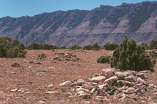
The Ewing-Snell Ranch was established between 1896 and 1898 by Erastus Ewing in Carbon County, Montana, on Layout Creek between Bighorn Canyon and the Pryor Mountains in a region called Dryhead Country. Ewing took up ranching after failing as a gold miner.
The Caroline Lockhart Ranch was established in 1926 by Caroline Lockhart, who purchased a 160-acre (65 ha) homestead near Davis Creek at the foot of the Pryor Mountains in Carbon County, Montana, while in her fifties. Lockhart expanded the ranch, adding buildings, land and grazing rights until the ranch comprised about 7,000 acres (2,800 ha). The region, known as Dryhead Country, is one of the most isolated places in Montana.

Cedarvale, also known as Hillsboro Ranch, was a dude ranch and working ranch in Carbon County, southern Montana, United States. The ranch was established about 1903 by prospector Grosvener W. Barry on the South Fork Trail Creek. Barry used the ranch as a home for his family and as a base for his mining ventures, all of which failed. His most lucrative venture was the conversion of Cedarvale from a working ranch to a dude ranch, marketed through an arrangement with the Chicago, Burlington and Quincy Railroad. It was the first dude ranch in the area. Barry introduced powered boats to the Bighorn River to carry dudes to the ranch from the railhead at Kane, Wyoming. As a publicity stunt Barry, his stepson and a neighbor piloted the 16-foot (4.9 m) motorized Edith from the Hillsboro landing down the Bighorn, Yellowstone, Missouri and Mississippi rivers, leaving on May 31, 1913 and arriving in New Orleans on August 1. One of Barry's boats, the Hillmont, is on display at Barry's Landing.

Bowler is an unincorporated community located in Carbon County, Montana, United States at 45.205°N 108.719°W.
References
- 1 2 Harvey, David (1974). "Dryhead Country". The Pryor Mountains. Pryors Coalition. Retrieved 6 March 2012.
- ↑ "Caroline Lockhart Ranch". Bighorn Canyon National Recreation Area. National Park Service. Retrieved 6 March 2012.