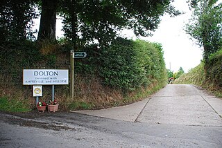
Dolton is a small village and civil parish in the Torridge district of Devon, in south-west England. The parish is surrounded, clockwise from the north, by the parishes of Beaford, Ashreigney, Winkleigh, Dowland, Meeth, Huish and Merton. The parish has a population of around 900. Dolton is in the electoral ward of Three Bridges which had a population at the 2011 census of 1,643.

Kraljevci is a village in Serbia. It is situated in the Ruma municipality, in the Srem District, Vojvodina province. The village has a Serb ethnic majority and its population numbering 1,232 people.

Krnješevci is a village in Serbia. It is situated in the Stara Pazova municipality, in the Srem District, Vojvodina province. The village has a Serb ethnic majority and its population numbering 1,025 people.
Mărăcineni is a commune in Argeș County, in southern central Romania. It is composed of two villages, Argeșelu and Mărăcineni.

Starosiele is a village in the administrative district of Gmina Dubienka, within Chełm County, Lublin Voivodeship, in eastern Poland, close to the border with Ukraine. It lies approximately 2 kilometres (1 mi) south of Dubienka, 31 km (19 mi) south-east of Chełm, and 95 km (59 mi) east of the regional capital Lublin.

Comișani is a commune in Dâmbovița County, southern Romania with a population of 5,355 people. It is composed of two villages, Comișani and Lazuri.
Siliștea Crucii is a commune in Dolj County, Romania with a population of 1,811 people. It is composed of a single village, Siliștea Crucii.
Băbiciu is a commune in Olt County, Romania. It is composed of a single village, Băbiciu.
Traian is a commune in Olt County, Romania. It is composed of a single village, Traian.
Iancu Jianu is a commune in Olt County, Romania, named after the 19th century Wallachian hajduk Iancu Jianu. It is composed of three villages: Dobriceni, Iancu Jianu and Preotești.
Prosienica is a village in the administrative district of Gmina Ostrów Mazowiecka, within Ostrów Mazowiecka County, Masovian Voivodeship, in east-central Poland. It lies approximately 13 kilometres (8 mi) north-east of Ostrów Mazowiecka and 102 km (63 mi) north-east of Warsaw.
Siemiątkowo is a village in Żuromin County, Masovian Voivodeship, in east-central Poland. It is the seat of the gmina called Gmina Siemiątkowo. It lies approximately 23 kilometres (14 mi) south-east of Żuromin and 99 km (62 mi) north-west of Warsaw.
Florianów is a village in the administrative district of Gmina Popów, within Kłobuck County, Silesian Voivodeship, in southern Poland. It lies approximately 4 kilometres (2 mi) west of Popów, 14 km (9 mi) north of Kłobuck, and 88 km (55 mi) north of the regional capital Katowice.
Zbory is a village in the administrative district of Gmina Popów, within Kłobuck County, Silesian Voivodeship, in southern Poland. It lies approximately 4 kilometres (2 mi) west of Popów, 14 km (9 mi) north of Kłobuck, and 88 km (55 mi) north of the regional capital Katowice.
Nasiedle is a village in the administrative district of Gmina Kietrz, within Głubczyce County, Opole Voivodeship, in south-western Poland, close to the Czech border. It lies approximately 11 kilometres (7 mi) south-west of Kietrz, 19 km (12 mi) south of Głubczyce, and 71 km (44 mi) south of the regional capital Opole.
Łukęcin is a village in the administrative district of Gmina Dziwnów, within Kamień County, West Pomeranian Voivodeship, in north-western Poland. It lies approximately 9 kilometres (6 mi) east of Dziwnów, 10 km (6 mi) north-east of Kamień Pomorski, and 72 km (45 mi) north of the regional capital Szczecin.
Derczewo is a village in the administrative district of Gmina Myślibórz, within Myślibórz County, West Pomeranian Voivodeship, in north-western Poland. It lies approximately 12 kilometres (7 mi) north of Myślibórz and 47 km (29 mi) south-east of the regional capital Szczecin.
Vvedensky, Vvedenskaya, or Vvedenskoye is the name of several rural localities in Russia.
Oszlár is a village in Borsod-Abaúj-Zemplén County in northeastern Hungary.
Medvedovsky, Medvedovskaya, or Medvedovskoye is the name of several rural localities in Russia:


