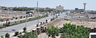
A UN-EUE mission, accompanied by two non-government organizations, surveying conditions in the Afar Region and visited Dubti 13 December 1995, at which time the town had one of two hospitals in Afar. While it offered the most advanced treatment in the Region, services available stopped short of surgery, providing only minor surgery under local anesthesia.[1]
Based on figures from the Central Statistical Agency published in 2005, Dubti has an estimated total population of 15,445, of whom 8,501 are men and 6,944 are women.[2] It is the largest of five towns in Dubtiworeda.
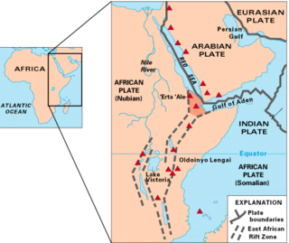
The Afar Triangle is a geological depression caused by the Afar Triple Junction, which is part of the Great Rift Valley in East Africa. The region has disclosed fossil specimens of the very earliest hominins; that is, the earliest of the human clade, and it is thought by some paleontologists to be the cradle of the evolution of humans. The Depression overlaps the borders of Eritrea, Djibouti and the entire Afar Region of Ethiopia; and it contains the lowest point in Africa, Lake Assal, Djibouti, at 155 m (509 ft) below sea level.
Kombolcha is a town and district in north-central Ethiopia. Located in the Debub Wollo Zone of the Amhara Region, it has a latitude and longitude of 11°5′N39°44′E with an elevation between 1842 and 1915 meters above sea level. Some guide books describe Kombolcha as the twin town of Dessie which lies some 12 kilometres (7.5 mi) to the northwest.
Asaita (Amharic: አሳይታ, Asayəta; Afar: Aysaqiita), known historically as Aussa (Awsa), is a town in northeastern Ethiopia, and until 2007 served as the capital of the Afar Region of Ethiopia. Located in the Afambo woreda, part of the region's Awsi Rasu zone, the town has a latitude and longitude of 11°34′N41°26′E and an elevation of 300 metres (980 ft).
The Afar Region, formerly known as Region 2, is a regional state in northeastern Ethiopia and the homeland of the Afar people. Its capital is the planned city of Semera, which lies on the paved Awash–Assab highway. It's bordered by Eritrea to the north and Djibouti to the northeast; it also shares regional borders with the Tigray, Amhara, Oromo and Somali regions.
Raaso district in Ethiopia is a district in the Somali Region of Ethiopia. situated in the Afder Zone,raaso sits as the most populated town in Afder Zone. The population of the district of Raaso is estimated to be around 941,000. The district of Raaso is inhabited by reer Aw Qudub( Sub-clan of the larger Sheekhaalclan). Raaso is situated along the Imi–Ginir road, some 40 kilometers north-west of West Imi village at a latitude and longitude of 6°32′N41°47′E. The other towns around Raaso district are Buundada which is located on Shabeelle River, Dhaley and others. The area is characterised by thick, hilly bushland with seasonal rivers nearby that may carry water after rains, and where it is easy to dig shallow wells to get water available throughout the year.
Awsi Rasu, also known as Administrative Zone 1, is a zone in the Afar Region of Ethiopia. This zone is bordered on the south by Gabi Rasu, on the southwest by Hari Rasu, on the west by the Amhara Region, on the northwest by Fantí Rasu, on the north by Kilbet Rasu, on the northeast by Eritrea, and on the east by Djibouti.
Mille is a woreda of Awsi Rasu within Afar Region, Ethiopia. It is named for the Mille River, a tributary of the Awash River. Mille is bordered on the south by the Administrative Zone 3, on the southwest by Administrative Zone 5, on the west by the Amhara Region, on the northwest by Chifra, on the northeast by Dubti, and on the southeast by the Somali Region. Towns in Mille include Mille and Eli Wuha.
Elidar is a woreda in Afar Region, Ethiopia. Part of the Administrative Zone 1, Elidar is bordered on the south by the Awash River which separates it from Asayita, on the west by Dubti, on the northwest by Kori, on the north by the Administrative Zone 2, on the northeast by Eritrea, and on the east by Djibouti. Towns in Elidar include Bure, Diche Oto, Elidar and Manda.
Dubti is a woreda in Afar Region, Ethiopia. Part of the Administrative Zone 1, Dubti is bordered on the south by the Somali Region, on the southwest by Mille, on the west by Chifra, on the northwest by the Administrative Zone 4, on the north by Kori, on the northeast by Elidar, on the east by Asayita, and on the southeast by Afambo. Towns in Dubti include Dubti, Logiya, and Semera.
Afdera is one of the districts of Ethiopia, or woredas, in the Afar Region of Ethiopia. It is named after the saline Lake Afdera, located in the southern part of the Afar Depression. Part of the Administrative Zone 2, Afdera is bordered on the southwest by the Administrative Zone 4, on the west by Erebti and Abala, on the north by Berhale, on the northeast by Eritrea, and on the southeast by Administrative Zone 1. The largest town of this woreda is Afdera.
Awash Fentale is a woreda in Afar Region, Ethiopia. Part of the Administrative Zone 3, Awash Fentale is bordered on the south by the Oromia Region, on the west by the Amhara Region, on the north by Dulecha, and on the east by Amibara. Towns in Awash Fentale include Awash Sebat Kilo and Sabure.
Elekere or Serer is one of the woredas in the Somali Region of Ethiopia. Part of the Afder Zone, Elekere is bordered on the southeast by Afder, on the southwest by Cherti, on the west by Goro Bekeksa, on the north by Mirab Imi, and on the east by Gode Zone. The major town in Elekere is El Kere.
Guradamole is one of the woredas in the Somali Region of Ethiopia. Part of the wacdi jamac nuur cilmi, Guradamole is bounded on the south by the Ganale Dorya River which separates it from the Liben Zone, on the west by Kersa Dula, on the north by the Oromia Region, and on the east by Goro Bekeksa. Towns in this woreda include Harardubo and Kundi.
Waliso is one of the Aanaas in the Oromia of Ethiopia. It was part of former Walisona Goro Aanaa what was separated for Goro (Aanaa) and Waliso Aanaa and Waliso Town. Part of the Southwest Shewa Zone, it was bordered on the south by the Southern Nations, Nationalities and Peoples Region, on the west by Amaya, on the northwest by Wonchi, on the north by Dawo, on the northeast by Becho and on the east by Saden Soddo. Towns in Waliso include Waliso and Dilala.
Mesela is a woreda in Oromia Region, Ethiopia. Part of the West Hararghe Zone, Mesela is bordered on the southwest by the Galetti River which separates it from Chiro, on the northwest by Tulo, and on the east by the East Hararghe Zone. Towns in Mesela include Goro Reye and Mesela.
Semera is the capital of Afar Region, Ethiopia. It is a town on the Awash–Assab highway in north-east Ethiopia, having been planned and built to replace Asaita. Located in Administrative Zone 1, Semera has a latitude and longitude of 11°47′32″N41°0′31″E. One of the completed buildings is Semera University, which began holding classes in 2007.
Kelafo is a town in eastern Ethiopia. Located in the Gode Zone of the Somali Region, this town has a latitude and longitude of 05°35′20″N44°12′20″E and an elevation of 233 meters above sea level.
Nefas Mewcha is a town in northern Ethiopia. Located in the Debub Gondar Zone of the Amhara Region, this town has a latitude and longitude of 11°44′N38°28′E and an elevation of 3150 meters above sea level. It is the administrative center of Lay Gayint woreda.
Kori is one of the Districts of Ethiopia, or woreda, in the Afar Region of Ethiopia. Part of the Administrative Zone 1, Kori is bordered on the south by Dubti, on the west the Administrative Zone 4, on the north by the Administrative Zone 2, on the east by Elidar. The administrative center is Ayrorta.
Chiro (also called Carcar ciroo in Oromo is a town and Aanaa in eastern Ethiopia. Located in the West Hararghe Zone in Oromia Regional State, Ethiopia Ahmar Mountains, it has a latitude and longitude of 9°05′N40°52′E and an altitude of 1826 meters above sea level. It is the administrative center of the West Hararghe Zone in Oromia Regional State.
This page is based on this Wikipedia article Text is available under the CC BY-SA 4.0 license; additional terms may apply. Images, videos and audio are available under their respective licenses.