Demographics
Based on the 2007 Census conducted by the Central Statistical Agency of Ethiopia (CSA), this Zone has a total population of 410,790, [4] of whom 224,656 are men and 186,134 women; with an area of 30,242.10 square kilometers, it has a population density of 13.58. While 82,886 or 20.18% are urban inhabitants, a further 178,557 or 43.47% were pastoralists. A total of 75,735 households were counted in this Zone, which results in an average of 5.4 persons to a household, and 78,104 housing units. Two largest ethnic groups reported in Zone 1 were the Afar (88.52%) and Amhara (9.97%); all other ethnic groups made up 1.51% of the population. Afar is spoken as a first language by 88.43%, and Amharic by 10.4%; the remaining 1.17% spoke all other primary languages reported. 96.55% of the population said they were Muslim, and 3.29% were Orthodox Christians. [5]
The 1996 national census reported a total population for this Zone of 327,901, of whom 186,616 were men and 141,285 women; 42,213 or 12.9% of its population were urban dwellers at the time. The major ethnic groupings in 1996 were 88.09% Afar, 9.98% Amhara, 0.75% Tigrean, and 0.71% Oromo. Of the school-age school-age children, 4.86% (5.05% male and 4.60% female) were currently attending school, which is higher than the Regional average; 11.28% of the total population over the age of 10 (12.93% male and 9.14% female) are reported to be literate. [6]

The Afar Region, formerly known as Region 2, is a regional state in northeastern Ethiopia and the homeland of the Afar people. Its capital is the planned city of Semera, which lies on the paved Awash–Assab highway.

Oromia Zone is a zone in Amhara Region of Ethiopia. Oromia is named for the Oromo people, who settled along the edge of the Ethiopian Highlands that form this Zone. Oromia Zone is bordered on the southwest by North Shewa Zone, on the northwest by South Wollo and Argobba special woreda, and on the east by the Afar Region. The Zone conists of 7 Woredas which are Artuma Fursi, Bati, Bati Town, Dewa Cheffa, Dewa Harewa, Jilye Tumuga and Kemisie town. Kamisee is the administrative center of the Zone.

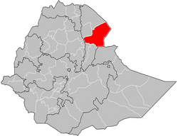
Gabi Rasu is a zone in Afar Region of Ethiopia. This zone is bordered on the south by the Oromia Region, on the southwest by the Amhara Region, on the west by the Administrative Zone 5, on the north by Administrative Zone 1, and on the east by the Somali Region.
Afambo is a woreda in Afar Region, Ethiopia. It is named after Lake Afambo, located at the border of this woreda with Asayita, near the international border with Djibouti. Part of the Administrative Zone 1, Afambo is bordered on the south by the Somali Region, on the west by Dubti, on the north by Asayita, and on the east by Djibouti. The largest town in this woreda is Afambo.
Elidar is a woreda in Afar Region, Ethiopia. Part of the Administrative Zone 1, Elidar is bordered on the south by the Awash River which separates it from Asayita, on the west by Dubti, on the northwest by Kori, on the north by the Administrative Zone 2, on the northeast by Eritrea, and on the east by Djibouti. Towns in Elidar include Bure, Diche Oto, Elidar and Manda.
Chifra is a woreda in Afar Region, Ethiopia. Part of the Administrative Zone 1, Chifra is located near the base of the eastern escarpment of the Ethiopian highlands and bordered on the south by Mille, on the west by the Amhara Region, on the north by the Administrative Zone 4, and on the east by Dubti; the Logiya River defines part of the boundary with Zone 4. The administrative center of Chifra is Chifra.
Dubti is a woreda in Afar Region, Ethiopia. Part of the Administrative Zone 1, Dubti is bordered on the south by the Somali Region, on the southwest by Mille, on the west by Chifra, on the northwest by the Administrative Zone 4, on the north by Kori, on the northeast by Elidar, on the east by Asayita, and on the southeast by Afambo. Towns in Dubti include Dubti, Logiya, and Semera.
Amibara is one of the Districts of Ethiopia, or woredas in the Afar Region of Ethiopia. Part of the Administrative Zone 3, Amibara is bordered on the south by Awash Fentale, on the west by the Awash River which separates it from Dulecha, on the northwest by the Administrative Zone 5, on the north by Gewane, on the east by the Somali Region, and on the southeast by Oromia Region. Towns in Amibara include Awash Arba, Awash Sheleko, Melka Sedi and Melka Were.
Awash Fentale is one of the Districts of Ethiopia, or woredas in the Afar Region of Ethiopia. Part of the Administrative Zone 3, Awash Fentale is bordered on the south by the Oromia Region, on the west by the Amhara Region, on the north by Dulecha, and on the east by Amibara. Towns in Awash Fentale include Awash Sebat Kilo and Sabure.
Gewane is one of the Districts of Ethiopia, or woredas, in the Afar Region of Ethiopia. Part of the Administrative Zone 3, Gewane is bordered on the south by Amibara, on the west by Bure Mudaytu and Administrative Zone 5, on the north by the Administrative Zone 1, and on the east by the Somali Region; the Awash River defines parts of the boundary with Administrative Zone 5. The administrative centre is Gewane; other towns in Gewane include Meteka.
Dulecha is one of the Districts of Ethiopia, or woredas, in the Afar Region of Ethiopia. Part of the Administrative Zone 3, Dulecha is bordered on the south by Awash Fentale, on the west by the Argobba special woreda, on the north by the Administrative Zone 5, and on the east by the Awash River which separates it from Amibara. The largest settlement in Dulecha is Dulecha.
Bure Mudaytu is one of the Districts of Ethiopia, or woredas in the Afar Region of Ethiopia. Part of the Administrative Zone 3, Bure Mudaytu stretches along a narrow band covering the marshy lowlands along the Awash River, with the Administrative Zone 5 to the west and Gewane to the east. The administrative center of this woreda is Debel.
Dewe is one of the Districts of Ethiopia, or woredas, in the Afar Region of Ethiopia. Part of the Administrative Zone 5, Dewe is located near the base of the eastern escarpment of the Ethiopian highlands, and bordered on the south by the Borkana River which separates it from Dalifage and Hadele Ele, on the west by the Amhara Region, on the north by Telalak, and on the east by Administrative Zone 3. The major settlement in this woreda is Wedarage. Dewe was the seat of the Sultanate of Dewe, one of the Afar's traditional sultanates in the Afar Region.
Simurobi Gele'alo is one of the Districts of Ethiopia, or woredas, in the Afar Region of Ethiopia. Part of the Administrative Zone 5, Simurobi Gele'alo is located near the base of the eastern escarpment of the Ethiopian highlands, and bordered on the west by the Amhara Region, on the north by Hadele Ele, and on the east and south by the Administrative Zone 3; the Awash River defines a part of the southern end of the eastern boundary of this woreda with Administrative Zone 3. The major settlement in this woreda is Kumame.

Atsbi Wemberta is one of the Districts of Ethiopia, or woredas, in the Tigray Region of Ethiopia. Located in the Misraqawi Zone at the eastern edge of the Ethiopian highlands, Atsbi Wenberta is bordered on the south by the Debub Misraqawi (Southeastern) Zone, on the west by Kilte Awulaelo, on the north by Saesi Tsaedaemba, and on the east by the Afar Region. The administrative center of this woreda is Atsbi ; other towns in Atsbi Wenberta include Haiqi Mesahil, Atsbi Dar'a, Kelisha Emni and Habes. The woreda is administratively divided into 18 tabiyas (municipalities).
Alamata is a woreda in Tigray Region, Ethiopia. Part of the Debubawi Zone, Alamata is bordered on the south and west by the Amhara Region, on the northwest by Ofla, and on the northeast by Raya Azebo. Towns in Alamata include Waja. The city of Alamata is a separate entity and is surrounded by Alamata woreda.
Kewet is a woreda in Amhara Region, Ethiopia. Part of the Semien Shewa Zone, Kewet is bordered on the southwest by Termaber, on the northwest by Menz Mam Midir, on the north by Efratana Gidim, and on the east by Afar Region. The major town in Kewet is Shewa Robit.
Bibugn is one of the woredas in the Amhara Region of Ethiopia. Part of the Misraq Gojjam Zone, Bibugn is bordered on the south by Sinan, on the west by Dega Damot woreda in the Mirab Gojjam Zone, on the northwest by Goncha, and on the east by Hulet Ej Enese. Towns in Bibugn include Digua Tsion, Weyin Wuha and Wabirr. Digo tsion (ድጎፅዮን) is the center of Bibugn wereda. There are over 15 kebelles in Bibugn wereda; among those, Debiresina is one of a kebelle that found in the north part.
Sekela is one of the woredas in the Amhara Region of Ethiopia. Part of the West Gojjam Zone, Sekela is bordered on the southwest by Bure, on the west by the Agew Awi Zone, on the north by Mecha, on the northeast by Yilmana Densa, on the east by Kuarit, and on the southeast by Jabi Tehnan. The administrative center of Sekela is Gish Abay.
Fentale is one of the districts in the Oromia of Ethiopia. Part of the East Shewa Zone located in the Great Rift Valley, Fentale is bordered on the southeast by the Arsi Zone, on the southwest by Boset, on the northwest by the Amhara Region, and on the northeast by the Afar Region. The administrative center of Fentale is Metehara; other towns include Haroo Adii.