
Lake Ontario is one of the five Great Lakes of North America. It is bounded on the north, west, and southwest by the Canadian province of Ontario, and on the south and east by the U.S. state of New York. The Canada–United States border spans the centre of the lake.

Lake Huron is one of the five Great Lakes of North America. Hydrologically, it comprises the easterly portion of Lake Michigan–Huron, having the same surface elevation as Lake Michigan, to which it is connected by the 5-mile-wide (8.0 km), 20-fathom-deep Straits of Mackinac. It is shared on the north and east by the Canadian province of Ontario and on the south and west by the U.S. state of Michigan. The name of the lake is derived from early French explorers who named it for the indigenous people they knew as Huron (Wyandot) inhabiting the region.

In oceanography, geomorphology, and geoscience, a shoal is a natural submerged ridge, bank, or bar that consists of, or is covered by, sand or other unconsolidated material and rises from the bed of a body of water to near the surface. It often refers to those submerged ridges, banks, or bars that rise near enough to the surface of a body of water as to constitute a danger to navigation. Shoals are also known as sandbanks, sandbars, or gravelbars. Two or more shoals that are either separated by shared troughs or interconnected by past or present sedimentary and hydrographic processes are referred to as a shoal complex.

Makapuʻu is the extreme eastern end of the Island of Oʻahu in the Hawaiian Islands, comprising the remnant of a ridge that rises 647 feet (197 m) above the sea. The cliff at Makapuʻu Point forms the eastern tip and is the site of a prominent lighthouse. The place name of this area, meaning "bulging eye" in Hawaiian, is thought to derive from the name of an image said to have been located in a cave here called Keanaokeakuapōloli. The entire area is quite scenic and a panoramic view is presented at the lookout on Kalanianaole Highway where the roadway surmounts the cliff just before turning south towards leeward Oʻahu and Honolulu.

The geography of New York (state) varies widely. Most of New York is dominated by farms, forests, rivers, mountains, and lakes. New York's Adirondack Park is larger than any U.S. National Park in the contiguous United States. Niagara Falls, on the Niagara River as it flows from Lake Erie to Lake Ontario, is a popular attraction. The Hudson River begins near Lake Tear of the Clouds and flows south through the eastern part of the state without draining lakes George or Champlain. Lake George empties at its north end into Lake Champlain, whose northern end extends into Canada, where it drains into the Richelieu River and then the St. Lawrence. Four of New York City's five boroughs are on the three islands at the mouth of the Hudson River: Manhattan Island, Staten Island, and Brooklyn and Queens on Long Island.

Mohawk Island is a small island in the northeast of Lake Erie, in Haldimand County, Ontario, Canada. It is composed of limestone with almost no vegetation, and is close to the water level. It was formerly known as Gull Island and contains the ruins of the Gull Island Lighthouse which was built in 1848 to guide ships into the Welland Canal at Port Maitland. In 1933, the lighthouse was automated to no longer require a human keeper and lost significance in 1934 due to the realignment of the canal at Port Colborne. It was decommissioned in 1969 when the mechanism was destroyed by a fire. The lighthouse is located close to the shore of Rock Point Provincial Park.
Little Galloo Island is located in eastern Lake Ontario near the entrance to Sackets Harbor in Jefferson County, New York, within the jurisdiction of the Town of Hounsfield.

Spectacle Reef Light is a lighthouse 11 miles (18 km) east of the Straits of Mackinac and is located at the northern end of Lake Huron, Michigan. It was designed and built by Colonel Orlando Metcalfe Poe and Major Godfrey Weitzel, and was the most expensive lighthouse ever built on the Great Lakes.

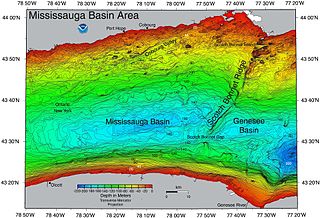
East Charity Shoal Light is an offshore lighthouse located near the Saint Lawrence River's entrance in northeastern Lake Ontario, due south of the city of Kingston, Ontario and approximately five miles (8 km) southwest of Wolfe Island. It is on the southeast rim of a 3,300-foot-diameter (1,000 m) submerged circular depression known as Charity Shoal Crater that may be the remnants of a meteorite impact.
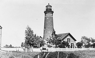
Galloo Island light is a historic lighthouse that is located the South Western side of the island of Galloo. It is found six miles off the mainland of Jefferson Country which is part of the state of New York. According to its location, it falls under the jurisdiction of the town of Hounsfield. The light tower and the majority of the island are privately owned. However, because of the law, the Coast Guard is permitted to cross into this private property because of the light in the tower that is used to guide ships. The lighthouse is a fixed white light that produces a beam that is visible at a maximum distance of 15 miles. It also consists of a steam whistle that it sounds when the weather turns foggy. The whistle blows for 10 seconds and then it is silent for 30 seconds. The island does not have a harbor and landings have to be made from smaller boats. Today it stands tall and abandoned, overlooking the waves.

Cape Town lies at the south-western corner of the continent of Africa. It is bounded to the south and west by the Atlantic Ocean, and to the north and east by various other municipalities in the Western Cape province of South Africa.

The Charity Shoal crater is a 1.2–1.4 kilometers (0.75–0.87 mi) in diameter circular feature that lies submerged beneath the northeast end of Lake Ontario about 12 kilometers (7.5 mi) southwest of Wolfe Island, and 25 kilometers (16 mi) south of Kingston, Ontario at about latitude 44° 02′ N and longitude 76° 29′ W. It is hypothesized to be a Middle Ordovician impact crater.
The Wisconsin Islands Wilderness is a 29-acre (12 ha) wilderness area located in Door County in northeastern Wisconsin. It is one of the smallest wilderness areas in the United States. Managed by the U.S. Fish & Wildlife Service, the wilderness area is composed of three islands in Lake Michigan.

Main Duck Island is a Canadian island in the eastern part of Lake Ontario situated next to the smaller Yorkshire Island. It was purchased by Parks Canada in 1977 and has been administered as part of the Thousand Islands National Park since 1998, even though it is not part of the Thousand Islands region.
Galloo Island is located in eastern Lake Ontario near the entrance to Sackets Harbor in Jefferson County, New York, within the jurisdiction of the Town of Hounsfield.

The Point Abino Light Tower is a lighthouse on the rocky north shore of Lake Erie at the southern tip of Point Abino peninsula west of Crystal Beach, Ontario, Canada. The Greek Revival white square tower with red accents is attached to the fog alarm building, and a lighthouse keeper's residence is located on the shore to the north.

Swetman Island, formerly False Duck Island, is a small Canadian island in Lake Ontario, south of Picton, Ontario. It is the largest island in a chain of islands and shoals known as the False Duck Islands, not to be confused with the nearby Main Duck Islands. Nearby Timber Island is also considered part of the False Duck Islands. The False Duck Islands, the Main Duck Islands, and Galloo Island and Stony Island on the US side, and their associated shoals, form the Duck Galloo Ridge.
Yorkshire Island is a small island in the east end of Lake Ontario, off Prince Edward County. It is part of a chain of islands, including Stoney Island, Galloo Island, Main Duck Island, and Swetman Island and Timber Island, the False Duck Islands. It was acquired by Parks Canada, in 1977, to preserve as nature preserves.
Timber Island is a 44-hectare (110-acre) island in the east end of Lake Ontario, off Prince Edward County, Canada. It is part of a chain of islands and shoals, including Stoney Island, Galloo Island, Main Duck Island, Yorkshire Island and Swetman Island. Timber Island and Swetman Island, and their nearby shoals, are known as the False Duck Islands.
Scotch Bonnet Ridge is a geologic ridge that crosses the Canada-United States border, in Lake Ontario, south of Prince Edward County. Scotch Bonnet Island and Nicholson Island lie off the shore of Prince Edward County.
