
Lake Ontario is one of the five Great Lakes of North America. It is bounded on the north, west, and southwest by the Canadian province of Ontario, and on the south and east by the U.S. state of New York. The Canada–United States border spans the centre of the lake.
Cape Vincent is a town in Jefferson County, New York, United States. The population was 2,765 at the 2020 census.

Central Frontenac is a township in eastern Ontario, Canada in the County of Frontenac.

The Bruce Peninsula is a peninsula in Ontario, Canada, that divides Georgian Bay of Lake Huron from the lake's main basin. The peninsula extends roughly northwestwards from the rest of Southwestern Ontario, pointing towards Manitoulin Island, with which it forms the widest strait joining Georgian Bay to the rest of Lake Huron. The Bruce Peninsula contains part of the geological formation known as the Niagara Escarpment.
The schooner or gunboat HMS Speedy sank in a snowstorm in Lake Ontario south of the future site of Brighton, Ontario, and west of Prince Edward County, on 8 October 1804, with the loss of all hands. The sinking changed the course of Canadian history because of the prominence of the citizens of the tiny colony of Upper Canada lost in the disastrous event.

Pointe au Baril is a community in the Canadian province of Ontario, located on the east coast of Georgian Bay.

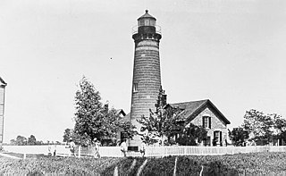
Point Clark is a lakefront cottage community on Lake Huron, in the municipality of Huron-Kinloss, Ontario, Canada. It is approximately 15 kilometres south of Kincardine and 40 kilometres north of Goderich. Main streets include Huron Road and Lake Range Road. Point Clark is served by Highway 21 (Ontario). It is a cottage town, and has a rare Imperial Tower style lighthouse. There is a sandy beach and a small harbour with a boat ramp. There are two streams or rivers that run into Lake Huron around Point Clark: Clark Creek and Pine River. There is a separate harbour in the mouth of the Pine River. Amberley is just outside and to the south of Point Clark and Lucknow is to the south-east of Point Clark.
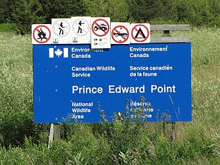
The Prince Edward Point Bird Observatory is a bird observatory located in the Prince Edward Point National Wildlife Area, located on Prince Edward Point in the south-east corner of Prince Edward County, Ontario, Canada. The National Wildlife Area was established in 1978 covering 560 hectares. The observatory was established in 1995 to monitor bird migrations across the point, continuing the work of the Kingston Field Naturalists who performed similar work in the 1970s and 1980s. The observatory was designated a Globally Important Birding Area in 1998 by the Canadian Nature Federation and Bird Studies Canada. It is also an International Monarch Butterfly Reserve.

East Charity Shoal Light is an offshore lighthouse located near the Saint Lawrence River's entrance in northeastern Lake Ontario, due south of the city of Kingston, Ontario and approximately five miles (8 km) southwest of Wolfe Island. It is on the southeast rim of a 3,300-foot-diameter (1,000 m) submerged circular depression known as Charity Shoal Crater that may be the remnants of a meteorite impact.
Galloo Island light is a historic lighthouse that is located the South Western side of the island of Galloo. It is found six miles off the mainland of Jefferson Country which is part of the state of New York. According to its location, it falls under the jurisdiction of the town of Hounsfield. The light tower and the majority of the island are privately owned. However, because of the law, the Coast Guard is permitted to cross into this private property because of the light in the tower that is used to guide ships. The lighthouse is a fixed white light that produces a beam that is visible at a maximum distance of 15 miles. It also consists of a steam whistle that it sounds when the weather turns foggy. The whistle blows for 10 seconds and then it is silent for 30 seconds. The island does not have a harbor and landings have to be made from smaller boats. Today it stands tall and abandoned, overlooking the waves.
Trillium Power Wind 1 (TPW1) is a proposed 450 to 500 megawatt (MW) far-offshore wind farm in the Canadian waters of northeastern Lake Ontario at least 17 to 28 km from the nearest mainland. This renewable energy project is being developed by Trillium Power Wind Corporation, a privately-held, Canadian-owned company headquartered in Toronto, Ontario. The project was placed in moratorium by the Ontario government on February 11, 2011 at exactly the same hour that Trillium Power was completing a $26 Million financing. A larger follow on equity investment of $400 Million was in discussion with two large global pension funds at the time. Had it not been placed in abeyance, TPW1 would have been the first offshore wind farm built in the Great Lakes. Recently, on January 19, 2023, the Ontario Court of Appeal heard an appeal by Trillium Power, focusing on evidence provided by Trillium Power of spoliation in an ongoing litigation by the Ontario Government.
The history of lighthouses in Canada dates back to 1734.
Waupoos Island is a community in Ontario, located within the municipality of Prince Edward County in the northwest quadrant of Prince Edward Bay. A private ferry service across Smith Bay from the hamlet of Waupoos on the mainland is operated by a holiday camp on Waupoos Island. The island is a favored anchorage for experienced sailors familiar with the rocky shoals in the area.

Main Duck Island is a Canadian island in the eastern part of Lake Ontario situated next to the smaller Yorkshire Island. It was purchased by Parks Canada in 1977 and has been administered as part of the Thousand Islands National Park since 1998, even though it is not part of the Thousand Islands region.

Pigeon Island is a small island, in Lake Ontario, near Kingston Ontario. The island had been a navigational hazard since the founding of Kingston, Ontario. A lighthouse was first built on Pigeon Island in 1870.

Scotch Bonnet Island is a small island in Lake Ontario. It is part of Prince Edward County, Ontario, Canada.

The Duck Galloo Ridge is a mainly underwater ridge, at the eastern end of Lake Ontario, spanning from Prince Edward County, Ontario to Jefferson County, New York. In pre-Columbian times native people used the islands on the ridge as way stations, when crossing the lake. The islands and shoals that dot the ridge have been navigational hazards since sailing ships first started navigating the lake.
Nicholson Island is a small island in Lake Ontario about 3 kilometres (1.9 mi) west of Prince Edward County, Ontario. It is one of the islands and shoals in the Scotch Bonnet Ridge.

Yorkshire Island is a small island in the east end of Lake Ontario, off Prince Edward County. It is part of a chain of islands, including Stoney Island, Galloo Island, Main Duck Island, and Swetman Island and Timber Island, the False Duck Islands. It was acquired by Parks Canada, in 1977, to preserve as nature preserves.
Timber Island is a 44-hectare (110-acre) island in the east end of Lake Ontario, off Prince Edward County, Canada. It is part of a chain of islands and shoals, including Stoney Island, Galloo Island, Main Duck Island, Yorkshire Island and Swetman Island. Timber Island and Swetman Island, and their nearby shoals, are known as the False Duck Islands.
