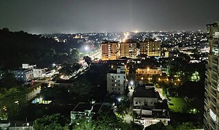
Dhanbad is the second-most populated city in the Indian state of Jharkhand after Jamshedpur. It ranks as the 42nd largest city in India and is the 33rd largest million-plus urban agglomeration in India. Dhanbad shares its land borders with Paschim Bardhaman district and Purulia district of West Bengal and Bokaro, Giridih and Jamtara districts of Jharkhand. The city is called the 'Coal Capital of India' for housing one of the largest coal mines in the country. The prestigious institute, Indian School of Mines is situated in Dhanbad. Apart from coal, it has also grown in information technology.

Giridih district is one of the twenty-four districts of Jharkhand state, India, and Giridih is the administrative headquarters of this district. As of 2011 it is the third most populous district of Jharkhand, after Ranchi and Dhanbad.
Pirtand is a community development block that forms an administrative division in the Dumri sub-division of the Giridih district in the Indian state of Jharkhand.
Jorapokhar is a neighbourhood in Dhanbad in Dhanbad Sadar subdivision of Dhanbad district in Jharkhand state, India.
Pathardih is a neighbourhood in Dhanbad in Dhanbad Sadar subdivision of Dhanbad district in Jharkhand state, India.
Rohraband is a neighbourhood in Dhanbad in Dhanbad Sadar subdivision of Dhanbad district in Jharkhand state, India.

Sudamdih is a neighbourhood in Dhanbad in Dhanbad Sadar subdivision of Dhanbad district in Jharkhand state, India.
Tundi is a community development block that forms an administrative division in Dhanbad Sadar subdivision of Dhanbad district, Jharkhand state, India.
Purbi Tundi is a community development block that forms an administrative division in Dhanbad Sadar subdivision of Dhanbad district, Jharkhand state, India.
Topchanchi is a community development block that forms an administrative division in Dhanbad Sadar subdivision of Dhanbad district, Jharkhand state, India.
Baghmara is a community development block that forms an administrative division in Dhanbad Sadar subdivision of Dhanbad district, Jharkhand state, India.
Govindpur is a community development block that forms an administrative division in Dhanbad Sadar subdivision of Dhanbad district, Jharkhand state, India.
Dhanbad is a community development block that forms an administrative division in Dhanbad Sadar subdivision of Dhanbad district, Jharkhand state, India.

Baliapur is a community development block that forms an administrative division in Dhanbad Sadar subdivision of Dhanbad district, Jharkhand state, India.
Nirsa is a community development block that forms an administrative division in Dhanbad Sadar subdivision of Dhanbad district, Jharkhand state, India.
Jharia was a community development block that formed an administrative division in Dhanbad district, Jharkhand state, India. Jharia has been merged with Dhanbad Municipal Corporation.

Baliapur is a census town in Baliapur CD block in Dhanbad Sadar subdivision of Dhanbad district in the Indian state of Jharkhand.It is Divided into 2 Parts.

Pradhan Khunta is a large village located in Baliapur Block of Dhanbad district, Jharkhand with total 840 families residing.It is located 199M above sea level.
Bardubhi is a village in Bardubhi Panchayat in Dhanbad CD block in Dhanbad Sadar subdivision of Dhanbad district in the Jharkhand state of India. Majority is Rajput caste is in the village.
Suranga is a census town in Baliapur CD block in Dhanbad Sadar subdivision of Dhanbad district in the Indian state of Jharkhand.


