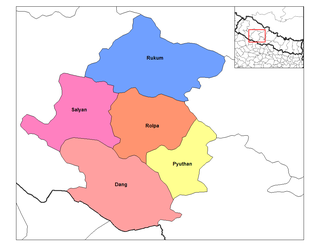
Rapti Zone was one of the fourteen zones, located in the Mid-Western Development Region of Nepal. It was named after the West Rapti River which drains Rolpa, Pyuthan and part of Dang districts. The remainder of Dang and part of Salyan district are drained by the Babai. The remainder of Salyan and all of Rukum districts are drained by the Bheri.

The Nepalese Civil War was a protracted armed conflict that took place in Nepal between the Communist Party of Nepal (Maoist) and the Government of Nepal from 1996 to 2006.

Pushpa Kamal Dahal, also widely known by his nom de guerre Prachanda, meaning "fierce", is a Nepalese politician who served as Prime Minister of Nepal from 2008 to 2009 and again from 2016 to 2017.

The Communist Party of Nepal , abbreviated CPN (Maoist), CPN-Maoist, CPN Maoist, or CPN(M), is the largest political party in Nepal. It was founded in 1994 after breaking away from the Communist Party of Nepal. The party has led three governments, from 2008 to 2009 and from 2016 to 2017 under Pushpa Kamal Dahal and from 2013 to 2015 under Baburam Bhattarai.
Dhankuta is a hill town and the headquarter of Koshi Zone located in Dhankuta District of Eastern Nepal. According to 2011 Nepal census, it has population of 26,440 inhabitants.

Rukum District was a "hill" and "mountain" district some 280 km (170 mi) west of Kathmandu partially belonging to Lumbini Province and partially to Karnali Province before split into two districts Western Rukum and Eastern Rukum after the state's reconstruction of administrative divisions in 2017. Rukum covers an area of 2,877 km2 (1,111 sq mi) with population of 207,290 in 2011 Nepal census. Musikot was the district's administrative center.

Pyuthan is a municipality in the Pyuthan District in the Lumbini Province of Nepal. It is also the District Headquarter and the administrative center of district. The municipality was established on 18 May 2014 by merging the existing Pyuthan Khalanga, Bijubar, Dakha Kwadi, Bijaya Nagar, Dharmawati, Maranthana and Khaira village development committees. In 2017, when GoN restructured the local level bodies into 753 units, Pyuthan Municipality was also restructured excluding ward no. 1, 2, 3, 5 and 18 from old structure, further two other VDC; Majhkot and Dumri added and managed the municipality into 10 new wards.

Damak, a city in eastern Nepal is one of the oldest municipalities in Jhapa District in Province No. 1 of Nepal. It is situated between the Ratuwa River in the east and the Maawa River in the west. It has Sivalik Hills in its north and ends with the intersection of Ratuwa River and Maawa River in the south. Mahendra Highway crosses this municipality nearly bisecting it. It is the largest city in Jhapa District as well as in Province No. 1 with a population of 75,743 in 2011 A.D

Ghorahi is the seventh largest city and largest sub-metropolitan city of Nepal. The city lies in Lumbini Province in the Mid-Western part of Nepal. It is the largest city of Dang Deukhuri District of southwest Nepal. Located in the Inner Terai region, it lies 413 kilometres (257 mi) south-west of Nepal's capital Kathmandu and is one of the Counter Magnets being developed as an alternative centre of growth to help ease the migration and population explosion in the Kathmandu metropolitan area. It is the largest city of the Rapti Zone and is surrounded by the Sivalik Hills to the south and Mahabharata Range to the north.

Triyuga is one of eight municipalities of Udayapur district of the Province No. 1 of Nepal. Gaighat is the headquarter of the municipality. According to the 1991 Nepal census, it had a population of 55,291. According to the 2011 Nepal census, Triyuga had 87,557 inhabitants. It is divided into 16 wards. Triyuga Municipality was established on B.S. Chaitra 13, 2053. It was named after Triyuga River. A river which flows through the town. Triyuga is the 3rd largest municipality in Nepal and 1st largest in Province No. 1 in term of size (area). The total area of the municipality is 547.43 square kilometres (211.36 sq mi)
Birtamode is a municipality in Jhapa District of Nepal. It is the commercial, educational and transport hub of Jhapa District. Sarnamati Bazar, Dhulabari Bazar, Dhaijan Bazar, Charali Bazar, Shivasatakshi Bazar, Kamatoli Bazar, Chakchaki Bazar and Surunga Bazar are some of the nearest local towns/settlements connected to Birtamod. it is one of the fastest growing city in Nepal. Birtamod is the largest city of Jhapa as well as in Mechi zone.

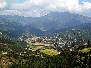
Tansen is a Municipality and the administrative center of Palpa District in the "hills" of western part of Nepal. It is located on the highway between Butwal and Pokhara, on the crest of the Mahabharat Range or Lesser Himalaya overlooking the valley of the Kaligandaki River to the north. The highway bypasses the town center on the west, protecting pedestrian amenities in the central maze of steep, narrow, winding alleys lined with Newari shop-Houses and temples.

Malangwa is a town, a municipality, and the headquarters of Sarlahi District in Province No. 2 of Nepal. The district's oldest municipality, it is in parliamentary constituency 2.From the Mahendra Highway 25 kilometres (16 mi) south of Nawalpur, a small highway side town. It is situated at an altitude of 79 meters (262 feet), Malangwa is near the Indian border at Sonbarsa. There is a customs checkpoint at the border crossing.
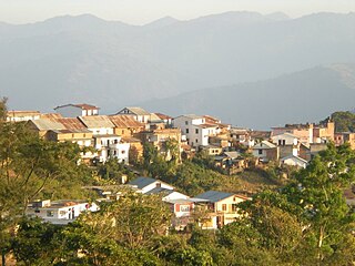
Sandhikharka Municipality is the headquarter of Arghakhanchi District which lies in Lumbini Province of Nepal. The former village development committee (VDC) was converted into a municipality on 18 May 2014 by merging the existing Sandhikharka, Wangla, Narapani, Khanchikot, Kimadada, Argha and Dibharna VDCs evdo. It is located, in a valley surrounded by hills, in the western part of the capital, Kathmandu.
Burtibang is a village development committee in Baglung District in the Dhaulagiri Zone of central Nepal. Burtibang is the second-largest commercial city in the district after Baglung.
Tulsipur is a Sub-Metropolitan City in Dang District of Lumbini Province of Nepal. As per population, it is the district's second most populous city after Ghorahi. It was established in 1992 by merging the former Village development committees Tulsipur and Amritpur. In 2014, it was expanded and the Village development committees of Urahari, Tarigaun, Pawannagar and Halwar. At the time of the 2011 Nepal census it had a population of 141,528 people living in 31,243 individual households.
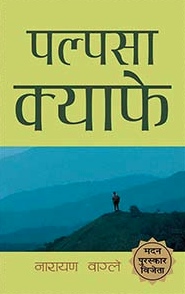
Palpasa Cafe is a novel by Nepali author Narayan Wagle. It tells the story of an artist, Drishya, during the height of the Nepalese Civil War. The novel is partly a love story of Drishya and the first generation American Nepali, Palpasa, who has returned to the land of her parents after 9/11. It is often called an anti-war novel, and describes the effects of the civil war on the Nepali countryside that Drishya travels to.
Bardaghat [नेपाली: बर्दघाट] is a Municipality in Parasi District in Lumbini Province, Nepal. It is situated in the lap of Chure range. This municipality was established on 18 May 2014 by merging existing Makar and Panchanagar VDCs. Again during the local election, the neighbouring VDC Dawanne devi and some part of Dhurkot, Jamuniya, Rupauliya were merged in it. It has a population of 55,382 with the area of 162.05 km2. It is an emerging town of Parasi District that is developing rapidly.

Province No. 1 is the easternmost of the seven provinces established by the new constitution of Nepal which was adopted on 20 September 2015. The province covers an area of 25,905 km2, about 17.5% of the country's total area. With the industrial city of Biratnagar as its headquarters, the province covers other major eastern towns including Damak, Dharan, Itahari, Inaruwa and Birtamod and includes several mountains including the Everest, Kanchenjunga, and Ama Dablam. Koshi – the largest river of the nation, circumvents the province's western boundary. Adhering to the first-past-the-post voting system issued by the Constituency Delimitation Commission, the province hosts 28 parliamentary seats and 56 provincial seats.

The 2004 Beni attack was one of the biggest attacks by the People's Liberation Army (PLA) of Communist Party of Nepal, Maoist, during the Nepalese Civil War (1996–2006). Almost the entire Western Division of the PLA, numbering around 3,500, attacked government positions in Beni, the district headquarters of Myagdi district in western Nepal, on 20 March 2004 at around 10 pm. Hundreds of civilians were used for logistics. Around 90 soldiers of the PLA and dozens of police and military personnel as well as civilians died. Multiple government buildings were destroyed and dozens of members of the civil service and government forces were kidnapped by the PLA.

