
Chitwan District is one of 77 districts of Nepal, and takes up the southwestern corner of Bagmati Province. Bharatpur, largest city of Nepal after Kathmandu, is its administrative centre. It covers 2,238.39 km2 (864.25 sq mi), and in 2011 had a population of 579,984 people. Bharatpur is the commercial and service centre of South Central Nepal and a major destination for higher education, health care and transportation in the region. Chitwan lies in the Terai region of Nepal. It is in the drainage basin of the Gandaki River and is roughly triangular, taking that river as its meandering northwestern border, and a modest watershed border, with India, as the basis of its southern limit. Local government: Bharatpur Metropolitan, Rapti Municipality, Ratnanagar Municipality, Kalika Municipality, Khairahani Municipality, Madi Municipality, Ikshyakamana Gaupalika

Kavrepalanchok District is one of the 77 districts of Nepal. The district, with Dhulikhel as its district headquarters, covers an area of 1,396 km2 (539 sq mi). It is a part of Bagmati Province and has a population of 381,937.

Nawalparasi District, part of which belongs to Gandaki Province and part to Lumbini Province, was one of the seventy-five districts of Nepal before being divided into Parasi District and Nawalpur District in 2015.

Syangja District, a part of Gandaki Province, is one of the seventy-seven districts of Nepal. The district, with Syangja bazaar as its district headquarters, covers an area of 1,164 km2 (449 sq mi) and had a population of 289,148 It lies in the hilly region at an altitude ranging from about 300 meters along the banks of Kaligandaki river up to a couple of thousands meters above the sea level. It lies at about latitude 28°4'60 North and longitude 83°52'0 East.
Bharatpur is a city in southern central Nepal. It is the third most populous city of Nepal after Kathmandu and Pokhara with 369,377 inhabitants in 2021. It is also the second largest metropolitan city in Nepal by area. It is the district headquarter of the Chitwan District.
Tandi is a city in the Ratnanagar Municipality of the Chitwan District in Nepal. It lies on the eastern side of Chitwan district, and is at the entrance point of Sauraha Chitwan National Park, a Major Tourist destination in Nepal.It is the second largest and oldest Urban Area of the district..This Beautiful Town has got the Space for All Major Banks and isurance Co.Of Nepal.This is the fastes Growing Town in Chitwan.It has got a very well Equipped National level Hospital which serves the people around Eastern part of Chitwan and makwanpur District.Almost 95% of the municipal area has got well managed paved roads.Tandi being the heart of the Ratnanagar,it is famous for Entry point to Sauraha and also renowned for Especial Tharu cuisine like ghunghi,Haas ko chhoila etc.this town has got all the basic to advanced facility of a (A-) class Town.
The Chitwan Valley is an Inner Terai valley in the south of Nepal, encompassing the districts of Makwanpur, Chitwan and Nawalpur. The valley is part of the Terai-Duar savanna and grasslands ecoregion of about 150 km (93 mi) length and 30–48 km (19–30 mi) width.
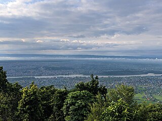
Ratnanagar is a municipality in Chitwan District of Bagmati Province in Nepal. It is the second biggest municipality after Bharatpur Metropolitan City that was formed in 1997 through the merger of the former Village Development Committees Old-Ratnanagar and Panchakanya. It is adjacent to Chitwan National Park, and serves as a gateway to the park. Agricultural products produced from Ratnanagar includes rice, maize, mustard and vegetables. This municipality is also a major place for production of poultry products and animal husbandry. Tourism is another source of income generation for the people in Ratnanagar. People are directly or indirectly dependent in tourism industry. Ratnanagar is also concerned in environment preservation so in order to preserve and protect environment, eco-friendly electric risk-shaw has also been introduced and available in different parts of this municipality. It lies on the bank of East Rapti River.

Dudhauli is a municipality of the Sindhuli District in the Janakpur Zone of south-eastern Nepal.

Kumroj is a town in Khairhani Municipality in Chitwan District in the Narayani Zone of southern Nepal. The municipality was promulgated on 18 May 2014 by merging the existing Khairahani, Kumroj and Chainpur VDCs. Kumroj is 190 km south-west of the Kathmandu valley stationed in the Rapti valley, also known as the Inner Terai or Dun. The village is situated at an altitude of 1000 ft above the sea level surrounded by two mountain ranges; the mahabharat ranges of hills on the north and the churiya siwalik hills on the south. The main point of attraction is the Chitwan National Park which today stands as a successful testimony of nature conservation in south Asia Region. Historically it was established in 1973 as the first national park of the Nepal to preserve a unique ecosystems significantly valuable to the whole world en routing this area on the world heritage site list in 1984. In the near future, this town would be one of the potential Eco-tourism village destination. Kumroj is dedicated to protect the wild animals, community forest and the Chitwan national park. Once the Southern belt of Nepal was afflicted by malaria epidemics. Tharu, the native tribe, were able to thrive even in malaria. As malaria subsided, more and more people started migrating in this place in the search of arable land, which eventually made Kumroj as a multicultural and multiethinic place. Irrigated low land has been the main stud of agriculture, permitting Rice-Rice-Pulse cropping pattern feasible.
Meghauli is a village and former Village Development Committee that is now part of Bharatpur Metropolitan City in Bagmati Province of central Nepal.

Kawasoti (Nepali: कावासोती) is a municipality in Nawalpur District, Gandaki Province, Nepal. It is 31 km (19 mi) west of Bharatpur and 85 km (53 mi) east of Butwal, approximately on the middle of Mahendra Highway. The Naryani River flows south of it, and the Mahabharat Range is north of it.
Gaindakot is a municipality in Nawalpur District in the Lumbini Zone of southern Nepal. It became a municipality in May 2014 by merging the existing Mukundapur, Amarapuri, and Gaindakot VDCs. It was again expanded by merging Ratanpur VDC. It is situated on the shore of Narayani River in the lap of Maula Kalika temple. So this place has a great possibility of tourism development. At the time of the 2011 Nepal census, it had a population of 58,841 and 13,623 individual households according to 2011 Nepal census. Contributed in the article by Prashant Subedi
Godawari is a municipality in Lalitpur District in Bagmati Province of Nepal. It was established on 2 December 2014 by merging the former Village development committees Godawari, Badikhel, Bisankhunarayan, Godamchaur and Thaiba of Lalitpur District of Bagmati Zone. The municipality area was again expanded in March 2017 to include in total 12 previous VDCs. The six VDCs added were Devichaur, Dukuchhap, Chhampi, Thecho, Chapagaun, Jharuwarasi and Lele. The centre of this municipality is located at Bajrabarahi.
Khairahani is a municipality in Chitwan District in Bagmati Province of southern Nepal. The municipality was established on 8 May 2014 by merging the existing Khairahani, Kumroj and Chainpur VDCs. At the time of the 1991 Nepal census it had a population of 13,629 people living in 2262 households.
Kalika is a municipality in Chitwan District in the Narayani Zone of southern Nepal. This municipality was established in 2015 AD by merging the existing Jutpani, Padampur, Shaktikhor and Siddhi VDCs.
Shahidnagar Danda is the city center in Nawalpur District in Gandaki Province of southern Nepal. It is located in Kawasoti municipality, ward number 16. Shahidnagar Danda is locally known as Danda Bazar. It is the most highly populated areas in Kawasoti municipality after Kawasoti itself and one with a well developed infrastructure.
Rapti Municipality is a municipality which lies in Eastern part of Chitwan district in Bagmati Province of Nepal. It was formed as municipality in 2015 by merging five existing village development committees, Birendranagar VDC, Bhandara VDC, Piple VDC, Lothar VDC and Korak VDC. Total area of this municipality is 99.40 and population of this municipality according to 2068 BS census is 46510.

Nawalpur is one of 11 districts of Gandaki Province of Nepal. The headquarters of the district is Kawasoti.
Darai people (Nepali:दरै) are an indigenous ethnic tribal community native to Nepal. Most of their population live in hills and inner terai of Nepal in the banks of Narayani river with the largest concentration in Tanahu, Chitwan,Gorkha, and Nawalparasi districts. They are known as Daroe, Darhi, Daraie, Daras, Darad and Darai. According to census of 2021 their population is 18,695.


