Arghakhanchi is one of the districts of Lumbini Province in Nepal. The district headquarter is Sandhikharka. The district covers an area of 1,193 km2 (461 sq mi) and has a population (2011) of 197,632. Its neighboring districts are Palpa in the east, Gulmi in the north, Kapilvastu District in the south and Pyuthan in the west. The district also covers 4.18km of daily busy road connecting Kapilvastu and Bhalubang, Lalmatiya, Dang with Rapti River as Mahendra Highway or Easy-West Highway.

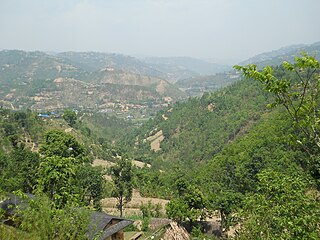
Bhojpur is one of the two urban municipalities of Bhojpur District of Province No. 1 of Nepal.
Sarlahi, a part of Madhesh Province, is one of the seventy-seven districts of Nepal. According to new laws, a combination of more than two or four villages makes a municipality, which covers an area of 1,259 km2 (486 sq mi) and had a population of 635,701 in 2001,769,729 in 2011 and 862,470 in 2021.

Udayapur District (Nepali: उदयपुर जिल्ला, is one of the 14 districts of Koshi Province in eastern Nepal. The district, with Triyuga as its district headquarters, covers an area of 2,063 km2 and in 2001 had a population of 287,689, in 2011 of 317,532, in 2021 of 342,773

Chandannath is a municipality in Jumla District in the Karnali Province of Nepal. The municipality was established on 18 May 2014 by merging the existing Mahat Gaun, Talium, Kartik Swami (Jumla), and Chandannath village development committees (VDCs). At the time of the 1991 Nepal census it had a population of 5,842 persons living in 1,000 individual households.

Nijgadh, is a town and municipality in Nepal, located in Bara District of the Madhesh Province. The total area of the municipality is 289.4 sq. km. The municipality was formed on 8 May 2014 by merging Nijgadh VDC with Ratnapuri VDC and Bharatganj Singaul VDC.
Bijaya Nagar is a town and market center located in Pyuthan Municipality in Pyuthan, a Middle Hills district of Lumbini Province, western Nepal. The formerly Village Development Committee along with Pyuthan Khalanga, Bijubar, Dakha Kwadi, Bijaya Nagar, Dharmawati, Maranthana and Khaira was merged to form the new municipality since 18 May 2014.
Bijuwar is a town and market center in Pyuthan Municipality in Pyuthan, a Middle Hills district of Rapti Zone, western Nepal. The former Village Development Committee along with Pyuthan Khalanga, Bijubar, Dakha Kwadi, Bijaya Nagar, Dharmawati, Maranthana and Khaira were merged to form the new municipality since 18 May 2014. Bijuwar is the main commercial center in the valley of Jhimruk Khola.
Chapakot is a municipality in the southeastern part of Syangja District in Gandaki Province of central Nepal. The new municipality was formed by merging three existing villages—Ratnapur, Kuwakot and Chapakot—on 18 May 2014. In 12 March 2017 The government implemented the new local administrative structure consisting of 744 local units. With the implementation of this new local administrative structure, the old structure will no longer be in existence. According to the new structure, VDCs will be replaced with village councils. Newly merged VDCs are Sankhar, Sekham, Ward no. 8 of Pakbadi & Ward no. of Malyangkot. The office of the municipality is that of the former Chapakot Municipality.
Birendranagar is a village development committee (VDC) in Chitwan District in the Narayani Zone of southern Nepal. At the time of the 2011 Nepal census it had a population of 14,934 people living in 3,374 individual households.
Gunjanagar is a town in Bharatpur, Chitwan in Bagmati Province of southern Nepal. The former Gunjanagar VDC and Saradanagar VDC were merged on 18 May 2014 to form new Chitrawan Municipality, which later was merged with Bharatpur. At the time of the 1991 Nepal census it had a population of 11,076 people living in 2025 individual households.
Meghauli is a small city and former Village Development Committee that is now part of Bharatpur Metropolitan City in Bagmati Province of central Nepal.

Belbari, officially known as Belbari municipality, is one of the major suburb of Morang district, Province No. 1. It lies in the eastern Terai region of Nepal. Previously a Village Development Committee (VDC), it was upgraded to the municipality status in 2014. In order to meet the requirements to become a municipality, Belbari VDC merged Kaseni VDC with itself, making it larger in total area. Moreover, in 2017 AD VDC like Dangihat and Bahuni merged with it to become present Belbari Municipality. Now it have 11 wards offices. It had a population of 81,837 people living in 18,945 households making it the third most populous city in Morang district.
Amarapuri is a town in Gaidakot Municipality in Nawalpur District in the Lumbini Zone of southern Nepal. It became a municipality in May 2014 by merging the existing Mukundapur, Amarapuri, Gaidakot, Nawalparasi, VDCs. At the time of the 2011 Nepal census it had a population of 8,762 living in 1,979 households. Amarapuri has three high schools, the Shree Laxmi Higher Secondary School, Amar Jyoti Higher Secondary School and Amar English Higher Secondary Boarding School.
Dibyapuri is a town in Devachuli municipality in the Nawalparasi District of the Lumbini Zone of southern Nepal. It was established on 18 May 2014 by merging existing Devachuli, Dibyapuri, and Pragatinagar village development committees. Divyapuri is a village development committee with Chaudhary Udyog Gram, a gas factory, a steel factory, and many brick factories and cottage industries. It is home to various people of different castes. Kadampur, Dhokan, Ambaschowk, Keurani, Paranpur, and Jhankre are locally well-known. Sakala Devi temple, two governmental schools, model health post of Nepal are also here. In the 1991 Nepal census it had a population of 4968 people living in 887 individual households.

Arunkhola is a town situated on the bank of the river Arun before as Naya Belhani VDC Ward No. 8 of Nawalparasi, but now as Madhyabindu Municipality, ward no. 10, Nawalpur District of Western Nepal. It is also known as Aarungkhola, Aarunkhola(Nepali: आरुणखोला) and Bhagra. It is an emerging business hub of the district.
Gaindakot is a municipality in Nawalpur District in the Gandaki Zone of southern Nepal. It became a municipality in May 2014 by merging the existing Mukundapur, Amarapuri, and Gaindakot VDCs. It was again expanded by merging Ratanpur VDC. It is situated on the shore of Narayani River in the lap of Maula Kalika temple. So this place has a great possibility of tourism development. At the time of the 2011 Nepal census, it had a population of 58,841 and 13,623 individual households according to 2011 Nepal census.

Madhyabindu is a municipality of Nawalpur District in Lumbini Zone of southern Nepal. The municipality was established on 19 September 2015 by merging the existing Tamasariya, Naya Belahani and Kolhuwa village development committees (VDCs). The center of the municipality is established in the former Tamasariya VDC of Chormara Bazaar. After merging the three VDCs population it had a total population of 28,224 according to 2011 Nepal census. After the government decision the number of Sub Metropolitan cities and municipalities has reached 12 and 217 respectively in Nepal.
Sundar Haraicha is a municipality in Morang District of Koshi Province in Nepal. It is centered around Biratchowk town which is the gateway to Biratnagar. It borders Itahari Sub- Metropolitan city to the west, Dharan Sub- Metropolitan city to the Northwest and Belbari municipality to the east and is connected by Mahendra Highway. It is one of the fastest growing cities in eastern Nepal and the second largest city of Morang district after Biratnagar, with 121,305 inhabitants living in 26,677 households. It consists of the town centres of Biratchowk and Gothgaun which are parts of the Greater Birat Development Area which incorporates the cities of Biratnagar-Itahari-Gothgau-Biratchowk-Dharan primarily located on the Koshi Highway in Eastern Nepal, with an estimated total urban agglomerated population of 804,300 people living in 159,332 households.
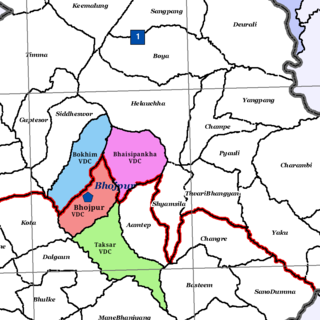
Bhojpur is a neighborhood in Bhojpur Municipality which is located in Bhojpur District in Province No. 1 of Nepal. The Bhojpur Village Panchayat was established in 1962 and was renamed Bhojpur Village Development Committee in 1990.


