Related Research Articles

Durban, nicknamed Durbs, is the third most populous city in South Africa after Johannesburg and Cape Town and the largest city in KwaZulu-Natal. Durban forms part of the eThekwini Metropolitan Municipality, which includes neighbouring towns and has a population of about 3.44 million, making the combined municipality one of the largest cities on the Indian Ocean coast of the African continent. Durban was also one of the host cities of the 2010 FIFA World Cup.
Ezemvelo KZN Wildlife is a governmental organisation responsible for maintaining wildlife conservation areas and biodiversity in KwaZulu-Natal Province, South Africa. Their headquarters is in Queen Elizabeth Park situated on the northern slopes of Pietermaritzburg, the KwaZulu-Natal provincial capital. Prior to 1994, it was known as the Natal Parks Board.

Kloof is a leafy upper-class town, that includes a smaller area called Everton, located approximately 26 km north-west of Durban in KwaZulu-Natal, South Africa. Once an independent municipality, it now forms part of greater Durban area of the eThekwini Metropolitan Municipality.
Inanda or eNanda is a township in KwaZulu-Natal, South Africa that is situated 21 km north-west of Durban. It forms part of eThekwini, the Greater Durban Metropolitan Municipality. Populated primarily by Zulu-speaking Black Africans, Inanda is the home of John Langalibalele Dube, first President of the African National Congress (ANC), a former residence and base of operations of Mahatma Gandhi, and the birthplace of the syncretic Nazareth Baptist Church

Durban North is an area to the north of Durban in the eThekwini Metropolitan Municipality, KwaZulu-Natal, South Africa. Durban North lies between the N2 freeway and the eastern seashore, with the Umgeni River forming its southern boundary. It has residential suburbs that are some of Durban's most affluent and is flanked by La Lucia in the north.

uMhlanga, alternatively rendered Umhlanga, is a residential, commercial and resort town north of Durban on the coast of KwaZulu-Natal, South Africa. It is part of the eThekwini Metropolitan Municipality, which was created in 2000 and includes the greater Durban area. The name means "place of reeds" in the Zulu language, and the correct pronunciation of "hl" in uMhlanga is similar to the Welsh "ll".

Vulamehlo Local Municipality was a local municipality in Ugu District Municipality, KwaZulu-Natal. It was located south of the eThekwini municipality and bordered by uMdoni to the east, Mkhambathini and Richmond to the north and Ubuhlebezwe to the west. There is an almost equal split of land between commercial agriculture and traditional settlement areas. 48% of the area is held under communal ownership through traditional authorities; the balance of the area is privately owned, except for Vernon Crookes Nature Reserve, which is managed by Ezemvelo KZN Wildlife. In 2016 the municipality was divided between eThekwini and uMdoni.
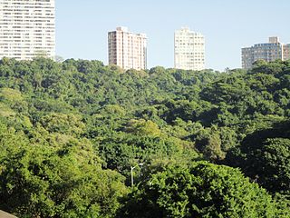
Burman Bush is a nature reserve in Morningside, Durban, situated some 8 km north of the CBD. At about 50 hectares it constitutes a small circular enclave of coastal forest which forms part of the Durban Municipal Open Space System (D'MOSS). It is the northern remnant of a forest that once covered much of the Berea ridge. The reserve's elevation varies from 19 to 133 m a.s.l.

eThekwini Metropolitan Municipality is a metropolitan municipality created in 2000, that includes the city of Durban, South Africa and surrounding towns. eThekwini is one of the 11 districts of KwaZulu-Natal province of South Africa. The majority of its 3,442,361 people speak Zulu. It was formed from seven formerly independent local councils and tribal land.
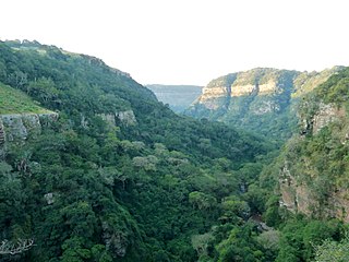
The Krantzkloof Nature Reserve, managed by Ezemvelo KZN Wildlife, conserves 668 ha of the Molweni and Nkutu River gorges that incise the sandstone Kloof plateau in KwaZulu-Natal, South Africa. The reserve conserves coastal scarp forest, sourveld grassland, a cliff face biotope, and aquatic environments along its rivers. Scarp forest is a threatened forest type, protected by South Africa's forests act of 1998, while the grassland is classified as KwaZulu-Natal sandstone sourveld, the most threatened terrestrial habitat in the Durban metropole. The reserve was established in 1950 and was augmented by land donations as late as 1999.
Virginia Bush Nature Reserve is a 38 hectare coastal bush reserve in the suburb of Durban North, Durban, South Africa. The reserve is currently under the auspices of the Durban Metropolitan Open Space System (D'MOSS).
Yellowwood Park is a quiet suburb of the city of Durban, South Africa, established in 1960. It is 14 km southwest of central Durban.
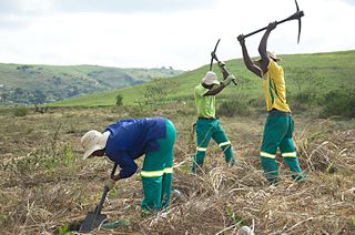
The Buffelsdraai Landfill Site Community Reforestation Project (BLSCRP) was initiated in 2008 to alleviate climate change impacts associated with hosting elements of the 2010 FIFA World Cup in Durban. The proposed carbon offset was to be achieved through the planting of more than 500 000 indigenous trees within the buffer zone of the Buffelsdraai Landfill Site. Restoring the forest ecosystem was identified as a way of "absorbing event-related greenhouse gas emissions while enhancing the capacity of people and biodiversity to adapt to the inevitable effects of climate change".
Alfred Park is a small wetland swamp forest in New Germany, KwaZulu-Natal, South Africa. It is managed by the Ethekwini Municipality.
Madwala Wildlife Sanctuary is a 102 hectare nature reserve in Assagay, Outer West Durban, South Africa. The reserve is managed by the eThekwini Municipality and is home to a number of mammals and birds.

Ethekwini, like most South African metropolitan areas, uses Metropolitan or "M" routes for important intra-city routes, a layer below National (N) roads and Regional (R) roads. Each city's M roads are independently numbered.

KwaZulu-Natal South Coast is a region along the southern stretch of coastline of KwaZulu-Natal, South Africa, south of the coastal city of Durban.
Silverglen Nature Reserve is a 460 hectare conservancy on the Umlaas River located aside the suburb of Silverglen, Chatsworth, KwaZulu-Natal in South Africa. The reserve is the largest piece of coastal grassland and bush clump mosaic in Greater Durban, and is home to the first medicinal plant nursery in Africa, established in 1986.
Giba Gorge Nature Reserve is an environmental precinct in Outer West Durban, South Africa. The gorge is a natural valley carved by the Giba River, with steep rocky cliffs and natural grassland slopes. Within the precinct is a mountain bike park with a 35km single track.