
The Grapes of Wrath is an American realist novel written by John Steinbeck and published in 1939. The book won the National Book Award and Pulitzer Prize for fiction, and it was cited prominently when Steinbeck was awarded the Nobel Prize in 1962.

The Dust Bowl was the result of a period of severe dust storms that greatly damaged the ecology and agriculture of the American and Canadian prairies during the 1930s. The phenomenon was caused by a combination of natural factors and human-made factors: a failure to apply dryland farming methods to prevent wind erosion, most notably the destruction of the natural topsoil by settlers in the region. The drought came in three waves: 1934, 1936, and 1939–1940, but some regions of the High Plains experienced drought conditions for as long as eight years.

The Plow That Broke the Plains is a 1936 short documentary film that shows the cultivation of the Great Plains region of the United States and Canada following the Civil War and leading up to the Dust Bowl as a result of farmers' exploitation of the Great Plains' natural resources.The Plow That Broke the Plains was the first film created by the US government for commercial release and distribution through the Resettlement Administration as part of President Roosevelt's New Deal program. The Resettlement Administration recruited Pare Lorentz to produce The Plow That Broke the Plains to support its campaign of showing the public that the search for profits in the West resulted in the displacement of settlers, misuse of the land, and ultimately resulted in the dust storms that affected the Great Plains regions in the 1930s. The film was one of the most widely publicized attempts by the U.S. federal government to communicate to its citizens through motion pictures.

Cimarron County is the westernmost county in the U.S. state of Oklahoma. Its county seat is Boise City. As of the 2020 census, its population was 2,296, making it the least-populous county in Oklahoma; and indeed, throughout most of its history, it has had both the smallest population and the lowest population density of any county in Oklahoma. Located in the Oklahoma Panhandle, Cimarron County contains the only community in the state (Kenton) that observes the Mountain Time Zone. Black Mesa, the highest point in the state, is in the northwest corner of the county. The Cimarron County community of Regnier has the distinction of being the driest spot in Oklahoma ranked by lowest annual average precipitation, at just 15.62 inches; at the same time, Boise City is the snowiest location in Oklahoma ranked by highest annual average snowfall, at 31.6 inches.

Morton County is a county in the southwestern corner of the U.S. state of Kansas. Its county seat and largest city is Elkhart. As of the 2020 census, the county population was 2,701. The county was named after Oliver Morton, the 14th governor of the state of Indiana.
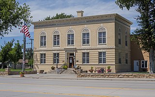
Baca County is a county located in the U.S. state of Colorado. As of the 2020 census, the population was 3,506. The county seat is Springfield. Located at the southeast corner of Colorado, the county shares state borders with Kansas, New Mexico, and Oklahoma.

Beaver is a town and county seat in Beaver County, Oklahoma, United States. The community is in the Oklahoma Panhandle. As of the 2020 census, the town’s population was 1,280. The city is host to the annual World Cow Chip Throwing Championship. Held in April, "Cow Chip" brings attention from nearby cities with a parade, carnival, and cowchip throwing.

Boise City is a city in and the county seat of Cimarron County, in the Panhandle of Oklahoma, United States. The population was 1,166 at the 2020 census, a decline of 7.9 percent from 1,266 in 2010.
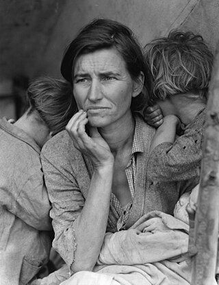
An Okie is a person identified with the state of Oklahoma, or their descendants. This connection may be residential, historical or cultural. For most Okies, several of these connections exist and are collectively the source of their being Oklahoman. While not an official demographic used or recognized by the United States Census Bureau, Okies, due to various factors, have developed their own distinct culture within larger social groupings both akin to and separate from Midwestern and Southern influences. Included are their own dialect, music, and Indigenous-derived folklore.

The Farm Security Administration (FSA) was a New Deal agency created in 1937 to combat rural poverty during the Great Depression in the United States. It succeeded the Resettlement Administration (1935–1937).
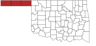
The Oklahoma Panhandle is a salient in the extreme northwestern region of the U.S. state of Oklahoma, consisting of Cimarron County, Texas County and Beaver County, from west to east. As with other salients in the United States, its name comes from the similarity of its shape to the handle of a pan.

Felt is a small unincorporated community and census-designated place (CDP) in Cimarron County, Oklahoma, United States. As of the 2020 census, the town’s population was 77. It was named for C.F.W. Felt of the Santa Fe Railroad. Nearby is the Cedar Breaks Archeological District, included on the National Register of Historic Places listings in Cimarron County, Oklahoma. The community is served by a post office and a school. During the Great Depression in 1936 a farm in Felt was the site of the iconic Dust Bowl photograph known as Dust Bowl Cimarron County, Oklahoma.
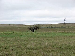
Rita Blanca National Grassland is a National Grassland on the Great Plains near the community of Texline in northwest Dallam County, Texas, in the Texas Panhandle, and in southern Cimarron County, Oklahoma, in the western Oklahoma Panhandle. The principal city in the area is Dalhart, Texas, which houses the XIT Museum.

Arthur Rothstein was an American photographer. Rothstein is recognized as one of America's premier photojournalists. During a career that spanned five decades, he provoked, entertained and informed the American people.

Dust Bowl Ballads is an album by American folk singer Woody Guthrie. It was released by Victor Records, in 1940. All the songs on the album deal with the Dust Bowl and its effects on the country and its people. It is considered to be one of the first concept albums. It was Guthrie's first commercial recording and the most successful album of his career.

Black Sunday refers to a particularly severe dust storm that occurred on April 14, 1935 as part of the Dust Bowl in the United States. It was one of the worst dust storms in American history and it caused immense economic and agricultural damage. It is estimated to have displaced 300 thousand tons of topsoil from the prairie area.

Arvin Federal Government Camp also known as the was built by the Farm Security Administration (FSA) south of Bakersfield, California, in 1936 to house migrant workers during the Great Depression. The National Register of Historic Places (NRHP) placed several of its historic buildings on the registry on January 22, 1996.
The Last Man Club was a mutual support group for farmers that chose to stay in the Southern Plains of Texas, US in spite of the devastation caused by the Dust Bowl disaster of the 1930s. It was the first American Dream.

The depopulation of the Great Plains refers to the large-scale migration of people from rural areas of the Great Plains of the United States to more urban areas and to the east and west coasts during the 20th century. This phenomenon of rural-to-urban migration has occurred to some degree in most areas of the United States, but has been especially pronounced in the Great Plains states, including Texas, Oklahoma, Kansas, Nebraska, South Dakota, North Dakota, Montana, Wyoming, Colorado, and New Mexico. Many Great Plains counties have lost more than 60 percent of their former populations.
Caroline Henderson (1877–1966) was an American schoolteacher, farmer and author during the Dust Bowl. Born Caroline Boa in Wisconsin and raised in Iowa, she attended Mount Holyoke College, graduating in 1901. After teaching in Iowa until 1907, she relocated to Texas County in the Oklahoma Panhandle. She married local farmer, Bill Henderson, in 1908, the same year when she bought a 160-acre farm near Eva, Oklahoma. Caroline and Bill had one daughter, Eleanor, born in 1909.


