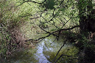
Dye Branch is a small creek that runs from Duke University's East Campus, through the Trinity Heights, Walltown, and Old West Durham neighborhoods of Durham, North Carolina. From its headwaters near the Food Lion grocery store on Hillsborough Road, Dye Branch (also known as South Ellerbe Creek) flows for three miles (5km) through some of Durham's oldest and most densely developed neighborhoods: Old West Durham, Walltown, Northgate Park, and Trinity Park. South Ellerbe joins Ellerbe Creek in a small forest—just northwest of the I-85/Roxboro Road interchange. Along some wooded stretches, the creek quietly flows over rocks and is as scenic as any in western North Carolina. In other areas, South Ellerbe is a troubled creek. Its history is marred by rampant pollution and devastating abuse. Though community organizations have arisen to advocate on behalf of the small drainage in recent years, future developments pose significant challenges.
Natural history
The pre-colonial Dye Branch likely meandered widely throughout the gently rolling woodlands of present-day Durham, NC on its way to Ellerbe Creek. The tiny brook possibly served as a natural center for thirsty flora and fauna. In any case, at the time of European discovery, the native Eno and Occoneechi tribes had already settled the region, and altered the landscape somewhat. Patches of land around the creek were cleared for agriculture and some of the forest burned to increase game. These alterations likely had some impact on Dye Branch, though such limited and disparate deforestation likely had little effect on the health of the Branch as a whole.
European colonization altered the landscape surrounding Dye Branch significantly. By the 18th century, small family farms replaced the forests in North Carolina, as harvested timber became a precious commodity—while streams like Ellerbe Creek were dammed to run newly built mills.
Tobacco’s emergence as a major cash crop transformed small subsistence farming operations into a disparate association of for-profit tract owners. However, the poor soil quality of the Dye Branch region insulated the creek from large land-owners. Dye Branch did not suffer extensive alteration directly by these large farming operations, but its location at the crossroads of these major operations invited the early urbanization that led to Durham’s formation.
By 1880, local businessmen reaped huge profits through the packaging and production of finished tobacco. The Duke family, capitalizing on the “relatively cheap” labor in the south, invested in the development of a massive textile operation geared toward the production of tobacco pouches. This new operation, the Erwin Mill, would prove a turning point, not only in the history of Dye Branch, but also in the history of Durham as a whole.
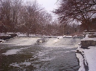
The building of Erwin Mills in 1893 created the mill village which would one day become Durham. This village and its mill meant devastation for water quality and quantity in Dye Branch for the next 90 years. Erwin Mill, built on the banks of the Dye Branch tributary poured chemical dyes into the small drainage, even as the progressive development of the area meant the small brook began to lose its natural meander. As the 1950s arrived, and the construction of North Carolina’s I-85 came to completion, urban water run-off and impervious surfaces also became sources of creek pollution.
Erwin Mills closed in 1986. Within a few years the Durham Freeway was completed, bisecting the former Erwin Park and Monkey Bottom. Most of the mill buildings were demolished. On part of the site in the late 1980s the Erwin Square office building was erected. By the 1990s, urban housing once centered on the mill and the jobs it provided, dominated the landscape up and down Dye Branch. The nature of the relationship between the small river and its people changed once again. Where Erwin Mill simply used Dye Branch to carry off waste dye, the creek now faced many of the problems associated with all urban streams.
Pollution Problems
As it flows through Old West Durham, Dye Branch is surrounded by various auto and muffler shops, large surface parking lots, a plumbing shop, funeral home, photo studio, small apartment complex, a chemical storage facility, Southern Railroad, Business Hwy 70, a Duke warehouse, and an old gas station. Many of these sites have direct run-off into the creek. The storm drains in the vicinity lead directly into the creek as well (pairs of storm drains near Hillsborough and Anderson streets are easy to spot).
As it flows through the Walltown neighborhood, the creek has actually cut deeply into the soil, causing property damage, and creating dangers for residents.
There is also a large "dye pond" surrounded by a screened fence near the creek. The dye pond remains from the Erwin textile mill. Run-off from the mill operations used to flow into the neighborhood (apparently, in the past, the area often smelled like a big laundromat from the warm, soapy water that flowed out of the mills).
The troubled creek also flows under the large parking surfaces at Northgate Mall and along the northern edge of Interstate-85 (the widening of this major corridor will have a direct impact on the creek and its surroundings).
Potential risks associated with these pollution sources include possible residues in the water or leaching into the surrounding soil and creek bed.
At its peaceful confluence with Ellerbe Creek, one could almost forget the troubled history of these waters. Few stretches remain that can still be protected. Fortunately, we understand that South Ellerbe is covered by Durham's new Resource Protection Ordinance (its headwaters drainage basin is greater than 25 acres (100,000m2) and the creek is designated on the USDA map). So, any new development would require stronger buffers.
The Potomac River is a major river in the Mid-Atlantic region of the United States that flows from the Potomac Highlands in West Virginia to the Chesapeake Bay in Maryland. It is 405 miles (652 km) long, with a drainage area of 14,700 square miles (38,000 km2), and is the fourth-largest river along the East Coast of the United States and the 21st-largest in the United States. More than 5 million people live within its watershed.
The Tualatin River is a tributary of the Willamette River in Oregon in the United States. The river is about 83 miles (134 km) long, and it drains a fertile farming region called the Tualatin Valley southwest and west of Portland at the northwest corner of the Willamette Valley. There are approximately 500,000 people residing on 15 percent of the land in the river's watershed.
The River Rouge is a 127-mile river in the Metro Detroit area of southeastern Michigan. It flows into the Detroit River at Zug Island, which is the boundary between the cities of River Rouge and Detroit.
The South Branch Potomac River has its headwaters in northwestern Highland County, Virginia, near Hightown along the eastern edge of the Allegheny Front. After a river distance of 139 miles (224 km), the mouth lies east of Green Spring, Hampshire County, West Virginia, where it meets the North Branch Potomac River to form the Potomac.
Ellerbe Creek is a tributary of the Neuse River in North Carolina, USA. It is part of the Neuse River Basin, and flows for more than twenty miles through North Durham. The Ellerbe's watershed begins near Orange County north of Interstate 85, near the WDNC radio tower and Bennett Place. The creek flows through many of Durham's most historic and culturally significant areas, including Ninth Street, Downtown Durham, beneath Durham Athletic Park, The North Carolina School of Science and Mathematics, the Museum of Life and Science, the old Durham Landfill, Duke University East Campus, Trinity Park, Walltown, Northgate Mall, and towards the end crosses Fishdam Road. The Ellerbe eventually flows into Falls Lake, about a mile south of the Eno River.
Daylighting is the opening up and restoration of a previously buried watercourse, one which had at some point been diverted below ground. Typically, the rationale behind returning the riparian environment of a stream, wash, or river to a more natural above-ground state is to reduce runoff, create habitat for species in need of it, or improve an area's aesthetics. In the United Kingdom, the practice is also known as deculverting.
Buffalo Creek is a tributary of the West Branch Susquehanna River in Union County, Pennsylvania, in the United States. It is approximately 28.5 miles (45.9 km) long and flows through Hartley Township, Lewis Township, West Buffalo Township, Mifflinburg, Buffalo Township, Kelly Township, and Lewisburg. Its watershed has an area of 134 square miles (350 km2). It is in the ridge-and-valley province of the Appalachian Mountains. Some streams and parts of streams in the creek's watershed are high-quality cold-water fisheries. There are ten types of rock formations and eight types of soil series in the watershed. The forests in the Buffalo Creek watershed are mostly deciduous hardwood, hemlock, and pine.
Little Fishing Creek is a tributary of Fishing Creek in Sullivan County, Lycoming County, and Columbia County, in Pennsylvania, in the United States. It is approximately 23.5 miles (37.8 km) long and flows through eight townships. The watershed of the creek has an area of 68.1 square miles (176 km2). The creek has six named tributaries, of which the largest are Spruce Run and West Branch Run.
Fanno Creek is a 15-mile (24 km) tributary of the Tualatin River in the U.S. state of Oregon. Part of the drainage basin of the Columbia River, its watershed covers about 32 square miles (83 km2) in Multnomah, Washington, and Clackamas counties, including about 7 square miles (18 km2) within the Portland city limits.
Twelve Mile Creek is a waterway located on the Niagara Peninsula in the Regional Municipality of Niagara in Southern Ontario, Canada. Its headwaters are located in the town of Pelham, encompassing some of the most unspoiled and natural areas of Niagara area. The creek's lower reaches flow through urban areas of Thorold and St. Catharines and has been heavily altered by human activity for almost two centuries. The creek was first known as "Ashquasing" by the Mississaugas Indigenous people, the name meaning "that which lies at the end" in the Anishinaabe language.
The Black River is a tributary of Lake Memphremagog, over 30 miles (48 km) long, in northern Vermont in the United States. It is one of the four major rivers in Orleans County. It is the longer but least powerful of the two rivers contained solely within the county. There are no longer any damsites.
A stream is a continuous body of surface water flowing within the bed and banks of a channel. Depending on its location or certain characteristics, a stream may be referred to by a variety of local or regional names. Long, large streams are usually called rivers, while smaller, less voluminous and more intermittent streams are known as streamlets, brooks or creeks.
A river is a natural flowing watercourse, usually a freshwater stream, flowing on the Earth's land surface or inside caves towards another waterbody at a lower elevation, such as an ocean, sea, bay, lake, wetland, or another river. In some cases, a river flows into the ground or becomes dry at the end of its course without reaching another body of water. Small rivers can be referred to by names such as creek, brook, and rivulet. There are no official definitions for these various generic terms for a watercourse as applied to geographic features, although in some countries or communities, a stream is customarily referred to by one of these names as determined by its size. Many names for small rivers are specific to geographic location; examples are "run" in some parts of the United States, "burn" in Scotland and Northeast England, and "beck" in Northern England. Sometimes a river is defined as being larger than a creek, but not always; the language is vague.
The South Fork Eel River is the largest tributary of the Eel River in north-central California in the United States. The river flows 105 miles (169 km) north from Laytonville to Dyerville/Founders' Grove where it joins the Eel River. The South Fork drains a long and narrow portion of the Coast Range of California in parts of Mendocino and Humboldt counties. U.S. Route 101 follows the river for much of its length.
Latah Creek, also known as Hangman Creek, is a large stream in eastern Washington and north central Idaho in the United States. The creek flows northwest from the Rocky Mountains to Spokane, where it empties into the Spokane River. It drains 673 square miles (1,740 km2) in parts of Benewah and Kootenai counties in Idaho, Spokane County and a small portion of Whitman County in Washington, where over 64 percent of its watershed resides. Some major tributaries of the approximately 60-mile (97 km) creek include Little Latah Creek and Rock Creek. The average flow of the creek can range from 20 cubic feet per second (0.57 m3/s) to 20,000 cubic feet per second (570 m3/s). Latah Creek receives its name from a Nez Perce word likely meaning "fish". In 1854, the creek received another name, Hangman Creek, from a war between the Palouse Indians and white soldiers, which resulted in several Palouse being hanged alongside the creek.
Little Nescopeck Creek is a tributary of Nescopeck Creek in Luzerne County, Pennsylvania, in the United States. It is approximately 8.5 miles (13.7 km) long and flows through Butler Township, Sugarloaf Township, and Conyngham. The watershed of the creek has an area of 14.0 square miles (36 km2). The creek is acidic and receives mine water from the Jeddo Tunnel. The main rock formation in the watershed is the Mauch Chunk Formation. However, the Pottsville Formation also appears in some areas. Soil series in the drainage basin include the Arnot Series, the Basher Series, and various other soil types.
Erwin Mill was a textile mill in Durham, North Carolina that operated between the years of 1893 and 1986. After seeing the success of other cotton mills in the Northeast and locally in Durham, entrepreneur Benjamin N. Duke incorporated the mill in 1892 and recruited William H. Erwin to manage the enterprise. The mill's success in the late 19th and early 20th centuries was the result of Erwin's and his successors' exceptional management tactics, even when the factory hit obstacles such as the Great Depression and the unionization of its workers. The mill grew quickly in the late 19th century and early 20th century, became one of North Carolina's largest cotton mills. It originally produced muslin pouches for tobacco, but the mill would later expand its production to other fabrics, becoming one of the largest producers of denim in the world during the early 1900s. Workers at the mill enjoyed some of the best working conditions and highest wages in textile factories throughout the southern United States. Mill employees would later sign union-friendly labor agreements that were radical to the southern textile industry in the early to mid 20th century. The establishment of homes, businesses and recreation areas in the mill village was a significant factor in the development of the West Durham, especially the Ninth Street business district and the Old West Durham Neighborhood. Erwin Mill No. 1 is on the National Register of Historic Places and the mill village of West Durham is a National Historic District. An apartment complex, office building and shopping center of the same name that are built on the original site also commemorate the factory.
North Branch Buffalo Creek is a tributary of Buffalo Creek in Centre County and Union County, in Pennsylvania, in the United States. It is approximately 13.5 miles (21.7 km) long and flows through Haines Township in Centre County and Hartley Township, Lewis Township, and West Buffalo Township. The watershed of the creek has an area of 22.9 square miles (59 km2). The creek has two named tributaries: Panther Run and Coal Run. Some streams in the watershed are impacted by nutrients, sedimentation, and siltation. The creek generally flows through mountainous terrain and has a sinuous channel. Rock formations made of sandstone are in its watershed and rock containing carbonate minerals is at its headwaters.
Beaver Creek is a stream in western Douglas and eastern Taney counties of Missouri. It is a tributary to the White River of northern Arkansas.
Walltown is a historically African-American neighborhood in Durham, North Carolina. The neighborhood is located between West Durham Historic District and Trinity Historic District, north of Duke University East Campus. Historically, the neighborhood was a working class neighborhood for African-American employees of Duke University and local tobacco and textile mills in Durham. Walltown was named after George Wall, a former enslaved person, who was one of the first people to purchase a lot in the area. Members of the community were active in the civil rights movement and desegregation in Durham. Since the beginning of the twenty-first century, Walltown has been undergoing gentrification.
This page is based on this Wikipedia article Text is available under the CC BY-SA 4.0 license; additional terms may apply. Images, videos and audio are available under their respective licenses.