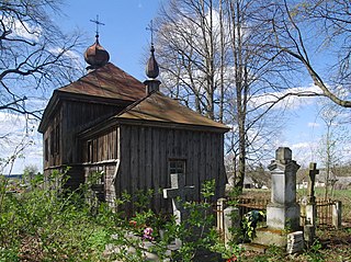
Lubaczów County is a unit of territorial administration and local government (powiat) in Subcarpathian Voivodeship, south-eastern Poland, on the border with Ukraine. It came into being on January 1, 1999, as a result of the Polish local government reforms passed in 1998. Its administrative seat and largest town is Lubaczów, which lies 81 kilometres (50 mi) east of the regional capital Rzeszów. The county contains three other towns: Oleszyce, 7 km (4 mi) west of Lubaczów, Narol, 26 km (16 mi) north-east of Lubaczów, and Cieszanów, 12 km (7 mi) north of Lubaczów.
Gmina Wielkie Oczy is a rural gmina in Lubaczów County, Subcarpathian Voivodeship, in south-eastern Poland, on the border with Ukraine. Its seat is the village of Wielkie Oczy, which lies approximately 17 kilometres (11 mi) south of Lubaczów and 83 km (52 mi) east of the regional capital Rzeszów.

Antoniki is a village in the administrative district of Gmina Lubaczów, within Lubaczów County, Subcarpathian Voivodeship, in south-eastern Poland, close to the border with Ukraine. It lies approximately 4 kilometres (2 mi) north-east of Lubaczów and 84 km (52 mi) east of the regional capital Rzeszów.

Bałaje is a village in the administrative district of Gmina Lubaczów, within Lubaczów County, Subcarpathian Voivodeship, in south-eastern Poland, close to the border with Ukraine. It lies approximately 3 kilometres (2 mi) north-east of Lubaczów and 83 km (52 mi) east of the regional capital Rzeszów.

Basznia Dolna is a village in the administrative district of Gmina Lubaczów, within Lubaczów County, Subcarpathian Voivodeship, in south-eastern Poland, close to the border with Ukraine. It lies approximately 7 kilometres (4 mi) east of Lubaczów and 88 km (55 mi) east of the regional capital Rzeszów.

Basznia Górna is a village in the administrative district of Gmina Lubaczów, within Lubaczów County, Subcarpathian Voivodeship, in south-eastern Poland, close to the border with Ukraine. It lies approximately 10 kilometres (6 mi) east of Lubaczów and 90 km (56 mi) east of the regional capital Rzeszów.

Borowa Góra is a village in the administrative district of Gmina Lubaczów, within Lubaczów County, Subcarpathian Voivodeship, in south-eastern Poland, close to the border with Ukraine. It lies approximately 8 kilometres (5 mi) east of Lubaczów and 88 km (55 mi) east of the regional capital Rzeszów.

Budomierz is a village in the administrative district of Gmina Lubaczów, within Lubaczów County, Subcarpathian Voivodeship, in south-eastern Poland, close to the border with Ukraine. It lies approximately 14 kilometres (9 mi) south-east of Lubaczów and 92 km (57 mi) east of the regional capital Rzeszów.

Dąbrowa is a village in the administrative district of Gmina Lubaczów, within Lubaczów County, Subcarpathian Voivodeship, in south-eastern Poland, close to the border with Ukraine. It lies approximately 6 kilometres (4 mi) south-east of Lubaczów and 83 km (52 mi) east of the regional capital Rzeszów.

Hurcze is a village in the administrative district of Gmina Lubaczów, within Lubaczów County, Subcarpathian Voivodeship, in south-eastern Poland, close to the border with Ukraine. It lies approximately 4 kilometres (2 mi) south-west of Lubaczów and 78 km (48 mi) east of the regional capital Rzeszów.

Krowica Hołodowska is a village in the administrative district of Gmina Lubaczów, within Lubaczów County, Subcarpathian Voivodeship, in south-eastern Poland, close to the border with Ukraine. It lies approximately 12 kilometres (7 mi) south-east of Lubaczów and 89 km (55 mi) east of the regional capital Rzeszów.

Krowica Sama is a village in the administrative district of Gmina Lubaczów, within Lubaczów County, Subcarpathian Voivodeship, in south-eastern Poland, close to the border with Ukraine. It lies approximately 12 kilometres (7 mi) south-east of Lubaczów and 87 km (54 mi) east of the regional capital Rzeszów.

Lisie Jamy is a village in the administrative district of Gmina Lubaczów, within Lubaczów County, Subcarpathian Voivodeship, in south-eastern Poland, close to the border with Ukraine. It lies approximately 3 kilometres (2 mi) south-east of Lubaczów and 84 km (52 mi) east of the regional capital Rzeszów.

Młodów is a village in the administrative district of Gmina Lubaczów, within Lubaczów County, Subcarpathian Voivodeship, in south-eastern Poland, close to the border with Ukraine. It lies approximately 4 kilometres (2 mi) east of Lubaczów and 84 km (52 mi) east of the regional capital Rzeszów.

Tymce is a village in the administrative district of Gmina Lubaczów, within Lubaczów County, Subcarpathian Voivodeship, in south-eastern Poland, close to the border with Ukraine. It lies approximately 10 kilometres (6 mi) north-east of Lubaczów and 90 km (56 mi) east of the regional capital Rzeszów.

Wólka Krowicka is a village in the administrative district of Gmina Lubaczów, within Lubaczów County, Subcarpathian Voivodeship, in south-eastern Poland, close to the border with Ukraine. It lies approximately 7 kilometres (4 mi) south-east of Lubaczów and 86 km (53 mi) east of the regional capital Rzeszów.

Załuże is a village in the administrative district of Gmina Lubaczów, within Lubaczów County, Subcarpathian Voivodeship, in south-eastern Poland, close to the border with Ukraine. It lies approximately 5 kilometres (3 mi) north-east of Lubaczów and 85 km (53 mi) east of the regional capital Rzeszów.

Żmijowiska is a village in the administrative district of Gmina Wielkie Oczy, within Lubaczów County, Subcarpathian Voivodeship, in south-eastern Poland, close to the border with Ukraine. It lies approximately 2 kilometres (1 mi) south-east of Wielkie Oczy, 18 km (11 mi) south of Lubaczów, and 85 km (53 mi) east of the regional capital Rzeszów.

Opaka is a village in the administrative district of Gmina Lubaczów, within Lubaczów County, Subcarpathian Voivodeship, in south-eastern Poland, close to the border with Ukraine. It lies approximately 5 kilometres (3 mi) south of Lubaczów and 79 km (49 mi) east of the regional capital Rzeszów.


