Mira is a municipality in Cuenca, Castile-La Mancha, Spain. It has a population of 1,127.

Amboy Township is one of twenty-two townships in Lee County, Illinois, USA. As of the 2010 census, its population was 3,108 and it contained 1,360 housing units.

San Jacinto del Cauca is a town and municipality located in the Bolívar Department, northern Colombia.

Cillaperlata is a municipality located in the province of Burgos, Castile and León, Spain. According to the 2004 census (INE), the municipality has a population of 44 inhabitants.

Partido de la Sierra en Tobalina is a municipality located in the province of Burgos, Castile and León, Spain. According to the 2004 census (INE), the municipality has a population of 68 inhabitants. Its seat is in Valderrama.

Maghnia District is a district of Tlemcen Province in north-western Algeria.
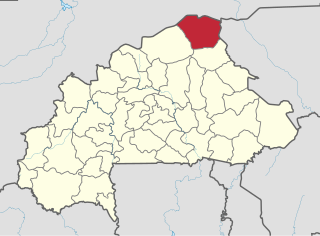
Iolonioro is a department or commune of Bougouriba Province in south-western Burkina Faso. Its capital lies at the town of Iiolonioro. According to the 2006 census the department has a population of 20,677.
Saint-Louis-du-Nord is an arrondissement in the Nord-Ouest department of Haiti. As of 2015, the population was 146,567 inhabitants. Postal codes in the Saint-Louis-du-Nord Arrondissement start with the number 32.

Góra is a village in the administrative district of Gmina Warta, within Sieradz County, Łódź Voivodeship, in central Poland. It lies approximately 10 kilometres (6 mi) west of Warta, 22 km (14 mi) north-west of Sieradz, and 68 km (42 mi) west of the regional capital Łódź.
Kościany is a village in the administrative district of Gmina Szczytniki, within Kalisz County, Greater Poland Voivodeship, in west-central Poland. It lies approximately 6 kilometres (4 mi) north-east of Szczytniki, 23 km (14 mi) east of Kalisz, and 127 km (79 mi) south-east of the regional capital Poznań.
Rów is a village in the administrative district of Gmina Myślibórz, within Myślibórz County, West Pomeranian Voivodeship, in north-western Poland. It lies approximately 12 kilometres (7 mi) north-west of Myślibórz and 49 km (30 mi) south of the regional capital Szczecin.
Ernest-Lepage Ecological Reserve is an ecological reserve of Quebec, Canada. It was established on April 27, 1983.

The Battle of Río Burbia or the Battle of the Burbia River was a battle fought in the year 791 between the troops of the Kingdom of Asturias, commanded by King Bermudo I of Asturias, and the troops of the Emirate of Córdoba, led by Yusuf ibn Bujt. The battle occurred in the context of the Ghazws of Hisham I against the Christian rebels of the northern Iberian Peninsula. The battle took place near the Río Burbia, in the area which is today known as Villafranca del Bierzo. The battle resulted in Andalusian victory.
The Battle of Las Cumbres also known as the Battle of Acultzingo was a skirmish at the Acultzingo Pass between the French invasion force under Charles de Lorencez and Mexican republican forces under Ignacio Zaragoza. It took place on 28 April 1862. Despite holding the high ground, Zaragoza was not willing to risk his forces by engaging the French Army in the open. As the French troops seized the first line of Mexican entrenchments, Zaragoza withdrew his forces to their stronghold of Puebla.
Visoka is a village in the Kardzhali Municipality, which is in the Kardzhali Province, in southern Bulgaria. As of 1 January 2007, the population of Visoka is 2 people, making it one of the least populated villages in the Kardzhali Municipality.
Palmira is a corregimiento in Boquete District, Chiriquí Province, Panama. It has a land area of 57.5 square kilometres (22.2 sq mi) and had a population of 1,776 as of 2010, giving it a population density of 30.9 inhabitants per square kilometre (80/sq mi). Its population as of 1990 was 2,043; its population as of 2000 was 1,513.
Santo Domingo is a corregimiento in Bugaba District, Chiriquí Province, Panama. It has a land area of 50.9 square kilometres (19.7 sq mi) and had a population of 2,625 as of 2010, giving it a population density of 51.5 inhabitants per square kilometre (133/sq mi). Its population as of 1990 was 1,988; its population as of 2000 was 2,276.
Peña Blanca is a corregimiento in Las Tablas District, Los Santos Province, Panama with a population of 875 as of 2010. Its population as of 1990 was 582; its population as of 2000 was 750.
Llano de Catival o Mariato is a corregimiento in Mariato District, Veraguas Province, Panama with a population of 2,376 as of 2010. It is the seat of Mariato District. Its population as of 1990 was 2,052; its population as of 2000 was 2,269.
Tusculum is a neighborhood in Nashville, within Davidson County, Tennessee. Tusculum is located along U.S. 41A/U.S. 31A 8.7 miles (14.0 km) south of downtown Nashville, 8.2 miles (13.2 km) north of Nolensville and 3.1 miles (5.0 km) west of Antioch.