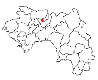
Koubia is a prefecture located in the Labé Region of Guinea in the Fouta Djallon mountains. Fulas are the majority ethnic group in the region with Fula (Pular) as the primary language. The capital is Koubia. The prefecture covers an area of 2,800 km.² and has an estimated population of 114,000.
Nation Lakes Provincial Park is a provincial park in British Columbia, Canada.
La Frontera is a municipality in Cuenca, Castile-La Mancha, Spain. It has a population of 203.

The Travel Air 2000/3000/4000, were open-cockpit biplane aircraft produced in the United States in the late 1920s by the Travel Air Manufacturing Company. During the period from 1924–1929, Travel Air produced more aircraft than any other American manufacturer, including over 1,000 biplanes.
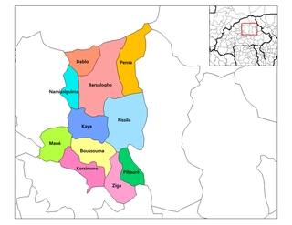
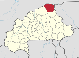
Pibaore is a department or commune of Sanmatenga Province in central Burkina Faso. Its capital lies at the town of Pibaore.
The VAXserver was a family of minicomputers developed and manufactured by Digital Equipment Corporation (DEC) using processors implementing the VAX instruction set architecture (ISA). The VAXserver models were variants of various VAX-based computers which were configured to only run operating systems which were licensed for network server use and not interactive time-sharing use. This was accomplished with different CPU modules and firmware.

Chojna is a village in the administrative district of Gmina Krosno Odrzańskie, within Krosno Odrzańskie County, Lubusz Voivodeship, in western Poland. It lies approximately 14 kilometres (9 mi) west of Krosno Odrzańskie and 43 km (27 mi) west of Zielona Góra.
Przyborowice is a village in the administrative district of Gmina Gubin, within Krosno Odrzańskie County, Lubusz Voivodeship, in western Poland, close to the German border. It lies approximately 14 kilometres (9 mi) south-east of Gubin, 21 km (13 mi) south-west of Krosno Odrzańskie, and 42 km (26 mi) west of Zielona Góra.
Nowy Dwór Prudnicki is a village in the administrative district of Gmina Krapkowice, within Krapkowice County, Opole Voivodeship, in south-western Poland. It lies approximately 9 kilometres (6 mi) south-west of Krapkowice and 30 km (19 mi) south of the regional capital Opole.
Gązwa is a village in the administrative district of Gmina Mrągowo, within Mrągowo County, Warmian-Masurian Voivodeship, in northern Poland. It lies approximately 6 kilometres (4 mi) north-west of Mrągowo and 50 km (31 mi) east of the regional capital Olsztyn.
Myśliborzyce is a village in the administrative district of Gmina Myślibórz, within Myślibórz County, West Pomeranian Voivodeship, in north-western Poland. It lies approximately 4 kilometres (2 mi) south of Myślibórz and 61 km (38 mi) south of the regional capital Szczecin.
Huépac Municipality is a municipality in Sonora in north-western Mexico.

El H'Madna District is a district of Relizane Province, Algeria.
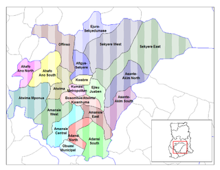
The Sekyere Afram Plains District is one of the twenty-seven (27) districts in the Ashanti Region of Ghana. Its capital is Kumawu. The district is among the new districts and municipalities created in 2008 by the then President, John Kufuor.
Sevindikli, Nazilli is a village in the District of Nazilli, Aydın Province, Turkey. As of 2010 it had a population of 459 people.

Kretinga Manor was a former residential manor located in the northern part of Kretinga, Lithuania.
Dos Ríos is a corregimiento in Dolega District, Chiriquí Province, Panama. It has a land area of 18.1 square kilometres (7.0 sq mi) and had a population of 1,634 as of 2010, giving it a population density of 90.2 inhabitants per square kilometre (234/sq mi). Its population as of 1990 was 1,172; its population as of 2000 was 1,352.
Campana is a corregimiento in Capira District, Panamá Oeste Province, Panama with a population of 2,067 as of 2010. Its population as of 1990 was 1,363; its population as of 2000 was 1,692.

The Ambush of Tin-Hama took place during the Tuareg rebellion of 2012, in March 25, 2012, when a convoy of the Ganda Izo militia was ambushed by the MNLA.