Gmina Rościszewo is a rural gmina in Sierpc County, Masovian Voivodeship, in east-central Poland. Its seat is the village of Rościszewo, which lies approximately 9 kilometres (5 mi) north-east of Sierpc and 112 km (69 mi) north-west of Warsaw

Pieńki Henrykowskie is a village in the administrative district of Gmina Brzeziny, within Brzeziny County, Łódź Voivodeship, in central Poland. It lies approximately 5 kilometres (3 mi) north-east of Brzeziny and 23 km (14 mi) east of the regional capital Łódź.
Otok PKP is a settlement in the administrative district of Gmina Zadzim, within Poddębice County, Łódź Voivodeship, in central Poland. It lies approximately 5 kilometres (3 mi) east of Zadzim, 15 km (9 mi) south of Poddębice, and 38 km (24 mi) west of the regional capital Łódź.
Grzybki is a village in the administrative district of Gmina Warta, within Sieradz County, Łódź Voivodeship, in central Poland. It lies approximately 4 kilometres (2 mi) north-west of Warta, 18 km (11 mi) north-west of Sieradz, and 60 km (37 mi) west of the regional capital Łódź.
Anielów is a village in the administrative district of Gmina Sobolew, within Garwolin County, Masovian Voivodeship, in east-central Poland. It lies approximately 9 kilometres (6 mi) north-east of Sobolew, 17 km (11 mi) south-east of Garwolin, and 73 km (45 mi) south-east of Warsaw.
Dąbek is a village in the administrative district of Gmina Troszyn, within Ostrołęka County, Masovian Voivodeship, in east-central Poland. It lies approximately 3 kilometres (2 mi) east of Troszyn, 15 km (9 mi) east of Ostrołęka, and 105 km (65 mi) north-east of Warsaw.
Białe-Giezki is a village in the administrative district of Gmina Boguty-Pianki, within Ostrów Mazowiecka County, Masovian Voivodeship, in east-central Poland.
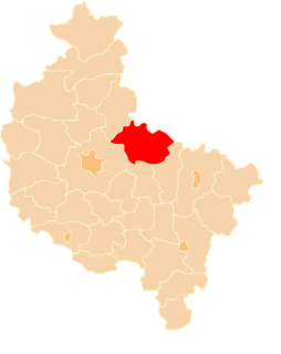
Marysin is a village in the administrative district of Gmina Potworów, within Przysucha County, Masovian Voivodeship, in east-central Poland.
Krzesk-Majątek is a village in the administrative district of Gmina Zbuczyn, within Siedlce County, Masovian Voivodeship, in east-central Poland.
Szumin is a village in the administrative district of Gmina Łochów, within Węgrów County, Masovian Voivodeship, in east-central Poland.
Żakowice is a village in the administrative district of Gmina Nowe Skalmierzyce, within Ostrów Wielkopolski County, Greater Poland Voivodeship, in west-central Poland. It lies approximately 8 kilometres (5 mi) north of Skalmierzyce, 23 km (14 mi) north-east of Ostrów Wielkopolski, and 100 km (62 mi) south-east of the regional capital Poznań.
Michałów is a village in the administrative district of Gmina Koniecpol, within Częstochowa County, Silesian Voivodeship, in southern Poland. It lies approximately 5 kilometres (3 mi) east of Koniecpol, 45 km (28 mi) east of Częstochowa, and 79 km (49 mi) north-east of the regional capital Katowice.
Żabczyce is a village in the administrative district of Gmina Głubczyce, within Głubczyce County, Opole Voivodeship, in south-western Poland.
Gapowo is a settlement in the administrative district of Gmina Brusy, within Chojnice County, Pomeranian Voivodeship, in northern Poland. It lies approximately 16 kilometres (10 mi) north-west of Brusy, 35 km (22 mi) north of Chojnice, and 79 km (49 mi) south-west of the regional capital Gdańsk.

Rytel is a village in the administrative district of Gmina Czersk, within Chojnice County, Pomeranian Voivodeship, in northern Poland. It lies approximately 14 kilometres (9 mi) west of Czersk, 17 km (11 mi) east of Chojnice, and 89 km (55 mi) south-west of the regional capital Gdańsk.
Krosewo is a settlement in the administrative district of Gmina Lipusz, within Kościerzyna County, Pomeranian Voivodeship, in northern Poland. It lies approximately 5 kilometres (3 mi) south of Lipusz, 16 km (10 mi) south-west of Kościerzyna, and 66 km (41 mi) south-west of the regional capital Gdańsk.

Janowice is a village in the administrative district of Gmina Nowa Wieś Lęborska, within Lębork County, Pomeranian Voivodeship, in northern Poland. It lies approximately 8 kilometres (5 mi) north-west of Nowa Wieś Lęborska, 10 km (6 mi) north-west of Lębork, and 70 km (43 mi) west of the regional capital Gdańsk.
Możdżanowo is a village in the administrative district of Gmina Ustka, within Słupsk County, Pomeranian Voivodeship, in northern Poland. It lies approximately 11 kilometres (7 mi) south-west of Ustka, 17 km (11 mi) west of Słupsk, and 122 km (76 mi) west of the regional capital Gdańsk.
Bałdy is a village in the administrative district of Gmina Purda, within Olsztyn County, Warmian-Masurian Voivodeship, in northern Poland. It lies approximately 15 kilometres (9 mi) south-west of Purda and 22 km (14 mi) south of the regional capital Olsztyn.
Łężek is a settlement in the administrative district of Gmina Postomino, within Sławno County, West Pomeranian Voivodeship, in north-western Poland. It lies approximately 8 kilometres (5 mi) west of Postomino, 16 km (10 mi) north of Sławno, and 179 km (111 mi) north-east of the regional capital Szczecin.