Otter Tail County is a county in the U.S. state of Minnesota. As of the 2020 census, its population was 60,081. Its county seat is Fergus Falls. Otter Tail County comprises the Fergus Falls micropolitan statistical area. With 1,048 lakes in its borders, Otter Tail County has more lakes than any other county in the United States.
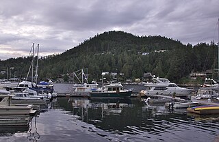
The Sunshine Coast is a geographic subregion of the British Columbia Coast that generally comprises the regional districts of qathet and Sunshine Coast.

Børgefjell National Park is an undeveloped national park in Norway, straddling the border between Trøndelag and Nordland counties, along the border with Sweden. The park is undeveloped with few trails or other facilities for visitors. Visitors can hike for extended periods without seeing another person. The 1,447-square-kilometre (559 sq mi) park was originally established in 1963, and it was enlarged in 1973 and 2003. It now includes land in the municipalities of Hattfjelldal, Grane, Namsskogan, and Røyrvik.

The Desolation Wilderness is a 63,960-acre (258.8 km2) federally protected wilderness area in the Eldorado National Forest and Lake Tahoe Basin Management Unit, in El Dorado County, California. The crest of the Sierra Nevada runs through it, just west of Lake Tahoe.

Ross Lake National Recreation Area is a US national recreation area in north central Washington just south of the Canada–US border. It is the most accessible part of the North Cascades National Park Complex which also includes North Cascades National Park and Lake Chelan National Recreation Area. Ross Lake NRA follows the Skagit River corridor from the Canada–US border to the western foothills of the Cascades. The NRA contains a portion of scenic Washington State Route 20, the North Cascades Highway, and includes three reservoirs: 12,000-acre (4,900 ha) Ross Lake, 910-acre (370 ha) Diablo Lake, and 210-acre (85 ha) Gorge Lake. These reservoirs make up the Skagit Hydroelectric Project operated by Seattle City Light. Nestled in the "American Alps" the Ross Lake NRA bisects the north and south units of North Cascades National Park.
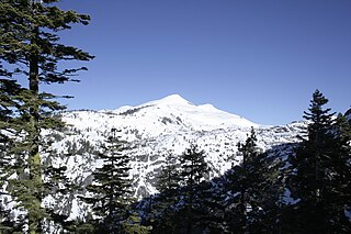
Pyramid Peak is a mountain in the California's Sierra Nevada in the Crystal Range to the west of Lake Tahoe. It is the highest point in the Desolation Wilderness. With an elevation gain of almost 4,100 feet (1,250 m), the Rocky Canyon route is the mountain's most popular approach although it is very arduous. To the east, at the base of the peak, lies Pyramid Lake.

Desolation Sound is a deep water sound at the northern end of the Salish Sea and of the Sunshine Coast in British Columbia, Canada.

Beyşehir is a large town and district of Konya Province in the Akdeniz region of Turkey. The town is located on the southeastern shore of Lake Beyşehir and is marked to the west and the southwest by the steep lines and forests of the Taurus Mountains, while a fertile plain, an extension of the lake area, extends in the southeastern direction. According to 2000 census, the population of the district is 118,144 of which 41,312 live in the town of Beyşehir.
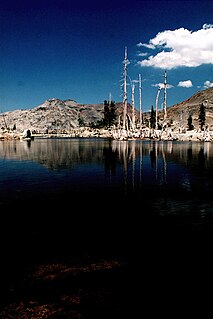
Lake Aloha is a large shallow backcountry reservoir located at an elevation of 8,116 feet in the Sierra Nevada Range, west of Lake Tahoe in El Dorado County, in eastern California.
Wrights Lake is in the Sierra Nevada mountain range, west of Lake Tahoe on the western border of the Desolation Wilderness. It can be reached via Wrights Road off U.S. Route 50 and the Ice House Road. It provides hiking access to the western portions of the Desolation Wilderness via the Twin Lakes trailhead. Wrights Road is not plowed and is inaccessible during the winter.

Gilmore Lake in California is a backcountry lake in the Sierra Nevada mountain range, to the west of Lake Tahoe in the Desolation Wilderness. It can be reached by hiking west out of the Glen Alpine Springs trailhead near the town of South Lake Tahoe. This lake offers great fishing for Lake trout.

The Eagle Falls trailhead or Eagle Lake trailhead is located in the El Dorado National Forest, in the Sierra Nevada, within Emerald Bay State Park, on the western shore of Lake Tahoe, California.

Mount Tallac is a mountain peak southwest of Lake Tahoe, in El Dorado County, California. The peak lies within the Desolation Wilderness in the Eldorado National Forest. It is quite visible from State Routes 89 and 28, and U.S. Route 50. A "cross of snow" is clearly visible on the mountain's face during the winter, spring, and early summer months.

Vermilion Bay is an unincorporated community on Vermilion Bay on Eagle Lake in the township of Machin, Kenora District in northwestern Ontario, Canada. It is located on Ontario Highway 17 between the cities of Kenora to the west and Dryden to the east.
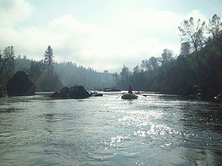
The South Fork American River is a major tributary of the American River in El Dorado County, California, draining a watershed on the western slope of the Sierra Nevada east of Sacramento. The river begins in pristine Desolation Wilderness and flows through the Sierra Nevada foothills. The river at Coloma was the site of James Marshall's discovery of gold at Sutter's Mill on January 24, 1848, which started the California Gold Rush. The South Fork of the American is "the most popular recreation stream in the West" for whitewater rafting in North America, e.g., 80,000 visitors in 2011.Professional whitewater rafting companies have been offering commercial rafting trips on the South Fork American River since 1978.

Desolation Canyon is a remote canyon on the Green River in eastern Utah, United States that is listed on the National Register of Historic Places (NRHP). It is said to be one of the remotest areas in the contiguous United States.

The Fish River is a 69.9-mile-long (112.5 km) river in northern Maine in the United States. It is a tributary of the Saint John River, which flows to the Bay of Fundy in New Brunswick, Canada.

The Hobbit: The Desolation of Smaug is a 2013 epic high fantasy adventure film directed by Peter Jackson from a screenplay by Fran Walsh, Philippa Boyens, Jackson, and Guillermo del Toro, based on the 1937 novel The Hobbit by J. R. R. Tolkien. The sequel to The Hobbit: An Unexpected Journey (2012), it is the second instalment in The Hobbit trilogy, acting as a prequel to Jackson's The Lord of the Rings trilogy.
Desolation Peak is located in the northern Wind River Range in the U.S. state of Wyoming. Situated .66 mi (1.06 km) west of Rampart Peak, Desolation Peak is within the Bridger Wilderness of Bridger-Teton National Forest and west of the Continental Divide. Desolation Peak is the 22nd tallest peak in Wyoming.


