
The Northwest Territories is a federal territory of Canada. At a land area of approximately 1,144,000 km2 (442,000 sq mi) and a 2016 census population of 41,790, it is the second-largest and the most populous of the three territories in Northern Canada. Its estimated population as of 2023 is 45,668. Yellowknife is the capital, most populous community, and only city in the territory; its population was 19,569 as of the 2016 census. It became the territorial capital in 1967, following recommendations by the Carrothers Commission.

Russia is the largest country in the world, covering over 17,125,192 km2 (6,612,074 sq mi), and encompassing more than one-eighth of Earth's inhabited land area. Russia extends across eleven time zones, and has the most borders of any country in the world, with sixteen sovereign nations.
Banks Island is one of the larger members of the Arctic Archipelago. Situated in the Inuvik Region, and part of the Inuvialuit Settlement Region, of the Northwest Territories, it is separated from Victoria Island to its east by the Prince of Wales Strait and from the mainland by Amundsen Gulf to its south. The Beaufort Sea lies to its west, and to its northeast M'Clure Strait separates the island from Prince Patrick Island and Melville Island.

Northern Canada, colloquially the North or the Territories, is the vast northernmost region of Canada, variously defined by geography and politics. Politically, the term refers to the three territories of Canada: Yukon, Northwest Territories and Nunavut. This area covers about 48 per cent of Canada's total land area, but has less than 0.5 per cent of Canada's population.
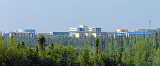
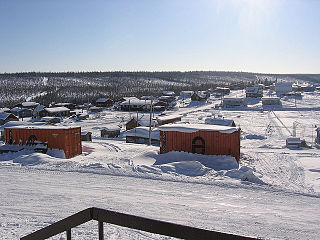
Inuvik is the only town in the Inuvik Region, and the third largest community in Canada's Northwest Territories. Located in what is sometimes called the Beaufort Delta Region, it serves as its administrative and service centre and is home to federal, territorial, and Indigenous government offices, along with the regional hospital and airport.

The Gwichʼin language belongs to the Athabaskan language family and is spoken by the Gwich'in First Nation (Canada) / Alaska Native People. It is also known in older or dialect-specific publications as Kutchin, Takudh, Tukudh, or Loucheux. Gwich'in is spoken primarily in the towns of Inuvik, Aklavik, Fort McPherson, and Tsiigehtchic, all in the Northwest Territories and Old Crow in Yukon of Canada. In Alaska of the United States, Gwichʼin is spoken in Beaver, Circle, Fort Yukon, Chalkyitsik, Birch Creek, Arctic Village, Eagle, and Venetie.

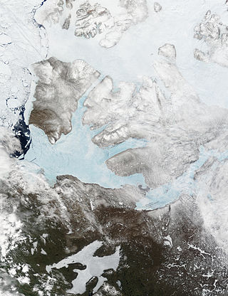
Amundsen Gulf is a gulf located mainly in the Inuvik Region, Northwest Territories, Canada with a small section in the Kitikmeot Region of Nunavut. It lies between Banks Island and Victoria Island and the mainland. It is approximately 250 mi (400 km) in length and about 93 mi (150 km) across where it meets the Beaufort Sea.
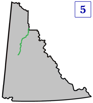
The Dempster Highway, also referred to as Yukon Highway 5 and Northwest Territories Highway 8, is a highway in Canada that connects the Klondike Highway in Yukon to Inuvik, Northwest Territories on the Mackenzie River delta. The highway crosses the Peel and the Mackenzie rivers using a combination of seasonal ferry services and ice bridges. Year-round road access from Inuvik to Tuktoyaktuk opened in November 2017, with the completion of the Inuvik–Tuktoyaktuk Highway, creating the first all-weather road route connecting the Canadian road network with the Arctic Ocean.

Tuktoyaktuk, or TuktuyaaqtuuqIPA:[təktujaːqtuːq], is an Inuvialuit hamlet located near the Mackenzie River delta in the Inuvik Region of the Northwest Territories, Canada, at the northern terminus of the Inuvik–Tuktoyaktuk Highway. One of six Inuvialuit communities in the Inuvialuit Settlement Region, it is commonly referred to by its first syllable, Tuk. It lies north of the Arctic Circle on the shores of the Arctic Ocean, and is the only place on the Arctic Ocean connected to the rest of Canada by road. Known as Port Brabant after British colonization, in 1950 it became the first Indigenous settlement in Canada to reclaim its traditional name.

Area code 867 is the area code in the North American Numbering Plan (NANP) for the three Canadian territories, all of which are in Northern Canada. The area code was created on October 21, 1997, by combining regions that were previously served with area code 403 and area code 819 in one numbering plan area (NPA). As the least populated NPA in mainland North America, serving about 130,000 people, it is geographically the largest, at 3,921,739 km2 (1,514,192 sq mi), with Alaska (907) a distant second.
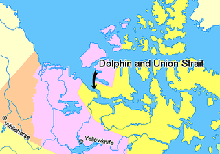
Dolphin and Union Strait lies in both the Northwest Territories and Nunavut, Canada, between the mainland and Victoria Island. It is part of the Northwest Passage. It links Amundsen Gulf, lying to the northwest, with Coronation Gulf, lying to the southeast. The southeastern end of the strait is marked by Austin Bay. It gets its name from the two boats used by the Scottish naval surgeon and explorer John Richardson, who was the first known European to explore it in 1826.
Fort Good Hope, is a charter community in the Sahtu Region of the Northwest Territories, Canada. It is located on a peninsula between Jackfish Creek and the east bank of the Mackenzie River, about 145 km (90 mi) northwest of Norman Wells.

Fort McPherson is a hamlet located in the Inuvik Region of the Northwest Territories, Canada. It is located on the east bank of the Peel River and is 121 km (75 mi) south of Inuvik on the Dempster Highway.

The Northwest Territories is a territory in Northern Canada, specifically in Northwestern Canada between Yukon Territory and Nunavut including part of Victoria Island, Melville Island, and other islands on the western Arctic Archipelago. Originally a much wider territory enclosing most of central and northern Canada, the Northwest Territories was created in 1870 from the Hudson's Bay Company's holdings that were sold to Canada from 1869-1870. In addition, Alberta and Saskatchewan were formed from the territory in 1905. In 1999, it was divided again: the eastern portion became the new territory of Nunavut. Yellowknife stands as its largest city and capital. It has a population of 42,800 and has an area of 532,643 sq mi (1,379,540 km2). The current territory lies west of Nunavut, north of latitude 60° north, and east of Yukon.

The Inuvialuit Settlement Region, abbreviated as ISR, located in Canada's western Arctic, was designated in 1984 in the Inuvialuit Final Agreement by the Government of Canada for the Inuvialuit people. It spans 90,650 km2 (35,000 sq mi) of land, mostly above the tree line, and includes several subregions: the Beaufort Sea, the Mackenzie River delta, the northern portion of Yukon, and the northwest portion of the Northwest Territories. The ISR includes both Crown Lands and Inuvialuit Private Lands.
The Arctic Council Indigenous Peoples’ Secretariat (IPS) is a secretariat for the six international Indigenous organizations affiliated with the eight-nation Arctic Council. The IPS does not represent indigenous peoples or their organizations, but assists those organizations in presenting their causes, and helps to disseminate information among them. IPS was established in 1994 under the auspices of the Arctic Environmental Protection Strategy (AEPS). It was around the same time that the category of Permanent Participants was being developed and applied to the three indigenous peoples’ organizations then observers in the AEPS. When the Arctic Council was established in 1996, both the Permanent Participants and IPS was reinserted into the new intergovernmental framework. Since commencing business in 1994, the role of the secretariat has been to facilitate contributions from the Permanent Participants to the cooperation of the eight Arctic states and to assist the Permanent Participants in performing, mainly communicational task.

The Arctic Circle is one of the two polar circles, and the most northerly of the five major circles of latitude as shown on maps of Earth at about 66° 34' N. Its southern equivalent is the Antarctic Circle.
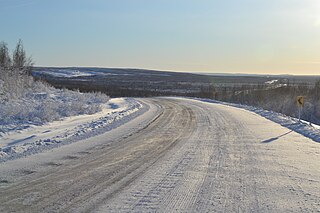
The Inuvik–Tuktoyaktuk Highway (ITH), officially Northwest Territories Highway 10, is an all-weather road between Inuvik and Tuktoyaktuk in the Northwest Territories, Canada. It is the first all-weather road to Canada's Arctic Coast. The idea for the highway had been considered for decades. Final approval came in 2013 and construction began in 2014. It was officially opened on November 15, 2017.

The Midnight Sun Mosque, also known as the Inuvik Mosque or Little Mosque on the Tundra, is a non-denominational Islamic house of worship located in Inuvik, Northwest Territories, Canada. The mosque was built in 2010 for the town's small Muslim community. It is the northernmost mosque in the Western Hemisphere and the only one in North America above the Arctic Circle.
