
Abraham Lincoln Capital Airport is a civil-military airport in Sangamon County, Illinois, three miles (6 km) northwest of downtown Springfield. It is owned by the Springfield Airport Authority (SAA).
Central Jersey Regional Airport is a privately owned, public use airport in Somerset County, New Jersey, United States. The airport is one nautical mile (2 km) south of the central business district of Manville. It is located in Hillsborough Township and was formerly known as Kupper Airport. This facility is included in the National Plan of Integrated Airport Systems for 2011–2015, which categorized it as a general aviation reliever airport.

Toledo Suburban Airport is a public use airport located two nautical miles (3.7 km) southwest of the central business district of Lambertville, a city in Monroe County, Michigan, United States. It is located just north of Michigan's border with Ohio and northwest of the city of Toledo, Ohio. It is included in the Federal Aviation Administration (FAA) National Plan of Integrated Airport Systems for 2017–2021, in which it is categorized as a general aviation facility.

St. Clair County Airport is a public use airport located three nautical miles southeast of the central business district of Pell City, in St. Clair County, Alabama, United States. It is owned by the St. Clair County Airport Authority. According to the FAA's National Plan of Integrated Airport Systems for 2009–2013, it is categorized as a reliever airport for the Birmingham-Shuttlesworth International Airport.

Cascade Locks State Airport is a public use airport located one nautical mile (2 km) northeast of the central business district of Cascade Locks, a city in Hood River County, Oregon, United States. It is owned by the Oregon Department of Aviation.

Pacific City State Airport is a public use airport located one nautical mile (2 km) south of the central business district of Pacific City, in Tillamook County, Oregon, United States. It is owned by the Oregon Department of Aviation.

Moton Field Municipal Airport is a public-use airport located three nautical miles north of the central business district of Tuskegee, a city in Macon County, Alabama, United States. The airport is owned by the City of Tuskegee. It is included in the FAA's National Plan of Integrated Airport Systems for 2011–2015, which categorized it as a general aviation facility.
Fernandina Beach Municipal Airport is a city-owned public-use airport located on Amelia Island three nautical miles (6 km) south of the central business district of Fernandina Beach, a city in Nassau County, Florida, United States. It is designated as a reliever airport for Jacksonville International Airport.
Eagle's Nest Airport is a public-use airport located three miles west of the central business district of Waynesboro, in Augusta County, Virginia, United States. It is privately owned by Michael L. Fogle.

Pittsburgh-Butler Regional Airport, also known as the Butler County Airport or K. W. Scholter Field, is a public airport 5 miles (8 km) southwest of the central business district of Butler, the county seat of Butler County, Pennsylvania, United States. The airport serves the northern suburbs of the Pittsburgh metropolitan area. It is owned by the Butler County Airport Authority.

Eagle Creek Airpark is a public use airport located seven nautical miles (13 km) west of the central business district of Indianapolis, a city in Marion County, Indiana, United States. It is owned by the Indianapolis Airport Authority and serves as a reliever airport for Indianapolis International Airport.

Pittsburgh Northeast Airport is a privately owned, public use airport in Allegheny County, Pennsylvania, United States. The airport is located 12 nautical miles north-northeast of the central business district of Pittsburgh, near the boroughs of Tarentum and Springdale. The airport is located a few miles north of Pittsburgh Mills shopping mall.

Maverick County Memorial International Airport is a county-owned public use airport in Maverick County, Texas, United States. It is located eight nautical miles north of the central business district of Eagle Pass, Texas.

Sonoma Skypark is a public-use airport located three nautical miles (6 km) southeast of the central business district of Sonoma, a city in Sonoma County, California, United States. It is privately owned by Sonoma Skypark, Inc.

Eagle River Union Airport is a city owned public use airport located in Eagle River, a city in Vilas County, Wisconsin, United States. It is included in the Federal Aviation Administration (FAA) National Plan of Integrated Airport Systems for 2019–2023, in which it is categorized as a local general aviation facility.

Tok Junction Airport is a state-owned public-use airport located one nautical mile east of the central business district of Tok, in the Southeast Fairbanks Census Area of the U.S. state of Alaska.

Randall Airport is a public use airport in Orange County, New York, United States. It is owned by Aerodrome Dev Corp and is located two nautical miles southeast of the central business district of the City of Middletown. According to the FAA's National Plan of Integrated Airport Systems for 2007-2011, it is categorized as a reliever airport.

Eagle Airpark is a public use airport in Mohave County, Arizona, United States. It is located 14 miles south of the central business district of Bullhead City.
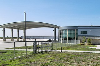
Austin Executive Airport is a public-use airport located in unincorporated Travis County, 12 mi (19 km) northeast of the central business district of Austin, and immediately southeast of Pflugerville. It was known as Bird's Nest Airport prior to 2011.
Salem–Leckrone Airport is a public use airport located two nautical miles (4 km) northwest of the central business district of Salem, a city in Marion County, Illinois, United States. It is owned by the Salem Airport Authority. This airport is included in the National Plan of Integrated Airport Systems for 2011–2015, which categorized it as a general aviation facility.


