
Poplar is a district in East London, England, now part of the London Borough of Tower Hamlets. Five miles (8 km) east of Charing Cross, it is part of the East End.

The London Borough of Tower Hamlets is a borough of London, England. Situated on the north bank of the River Thames and immediately east of the City of London, the borough spans much of the traditional East End of London and includes much of the regenerated London Docklands area. The 2019 mid-year population for the borough is estimated at 324,745.

The Rotherhithe Tunnel, designated the A101, is a road tunnel under the River Thames in East London, connecting Limehouse in the London Borough of Tower Hamlets north of the river to Rotherhithe in the London Borough of Southwark south of the river. It was formally opened in 1908 by George, Prince of Wales, and Richard Robinson, Chairman of the London County Council. It is a rare example of a road tunnel where road traffic, pedestrians and cyclists all share the same tunnel bore. Transport for London took over ownership and maintenance of the tunnel in 2001.

Bromley, commonly known as Bromley-by-Bow, is a district in the London Borough of Tower Hamlets in East London, located on the western banks of the River Lea, in the Lower Lea Valley in East London.

The West India Docks are a series of three docks, quaysides and warehouses built to import goods from and export goods and occasionally passengers to the British West Indies on the Isle of Dogs in London the first of which opened in 1802. Following their commercial closure in 1980, the Canary Wharf development was built around the wet docks by narrowing some of their broadest tracts.

Blackwall is an area of Poplar, in the London Borough of Tower Hamlets, East London. The neighbourhood includes Leamouth and the Coldharbour conservation area.
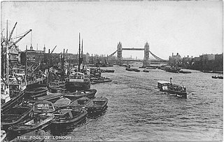
The Pool of London is a stretch of the River Thames from London Bridge to below Limehouse.
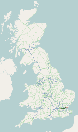
The A13 is a major road in England linking Central London with east London and south Essex. Its route is similar to that of the London, Tilbury and Southend line via Rainham, Grays, Tilbury, Stanford-Le-Hope & Pitsea,and runs the entire length of the northern Thames Gateway area, terminating on the Thames Estuary at Shoeburyness. It is a trunk road between London and the Tilbury junction, a primary route between there and Sadlers Hall Farm near South Benfleet, and a non-primary route between there and Shoeburyness.
Originally called the Commercial Railway, the London and Blackwall Railway (L&BR) in east London, England, ran from Minories to Blackwall via Stepney, with a branch line to the Isle of Dogs, connecting central London to many of London's docks. It was operational from 1840 until 1926 and 1968, closing after the decline of inner London's docks. Much of its infrastructure was reused as part of the Docklands Light Railway. The L&BR was leased by the Great Eastern Railway in 1866, but remained independent until absorbed into the London and North Eastern Railway at the 1923 Grouping. Another branch was opened in 1871, the Millwall Extension Railway.
The North London Railway (NLR) company had lines connecting the northern suburbs of London with the East and West India Docks further east. The main east to west route is now part of London Overground's North London Line. Other NLR lines fell into disuse but were later revived as part of the Docklands Light Railway, and London Overground's East London Line. The company was originally called the East & West India Docks & Birmingham Junction Railway (E&WID&BJR) from its start in 1850, until 1853. In 1909, it entered into an agreement with the London and North Western Railway which introduced common management, and the NLR was taken over completely by the LNWR in 1922. The LNWR itself became part of the LMS from the start of 1923. The railways were nationalised in 1948 and most LMS lines, including the North London route, then came under the control of the London Midland Region of British Railways.
Commercial Road is a street in the London Borough of Tower Hamlets in the East End of London. It is 1.9 miles (3.1 km) long, running from Gardiner's Corner, through Stepney to the junction with Burdett Road in Limehouse at which point the route splits into the East India Dock Road and the West India Dock Road. It is an artery connecting the historic City of London with the more recently developed financial district at Canary Wharf, and part of the A13.

East London is the northeastern part of London, England, east of the ancient City of London and north of the River Thames as it begins to widen. East London developed as London's docklands and the primary industrial centre. The expansion of railways in the 19th century encouraged the eastward expansion of the East End of London and a proliferation of new suburbs. The industrial lands of East London are today an area of regeneration, which are well advanced in places such as Canary Wharf and ongoing elsewhere.

The East India Docks were a group of docks in Blackwall, east London, north-east of the Isle of Dogs. Today only the entrance basin and listed perimeter wall remain visible.

Bow was a railway station in Bow, east London, that was opened in 1850 by the East & West India Docks and Birmingham Junction Railway, which was later renamed the North London Railway (NLR). The station was situated between Old Ford and South Bromley, and was located on the north side of Bow Road, close to the second Bow Road station which was open from 1892 to 1949. A covered footway connected the two stations between 1892 and 1917.
Poplar (East India Road) was a railway station located on the East India Dock Road in Poplar, London. It was opened in 1866 by the North London Railway. It was the southern passenger terminus of the NLR, although goods trains ran on to connect to the London and Blackwall Railway (LBR) for the East India Docks or to the LBR's Millwall Extension Railway for the West India Docks.
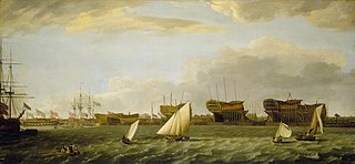
Blackwall Yard is a small body of water that used to be a shipyard on the River Thames in Blackwall, engaged in ship building and later ship repairs for over 350 years. The yard closed in 1987.

The Port of Tilbury is a port on the River Thames at Tilbury in Essex, England. It is the principal port for London, as well as being the main United Kingdom port for handling the importation of paper. There are extensive facilities for containers, grain, and other bulk cargoes. There are also facilities for the importation of cars. It forms part of the wider Port of London.
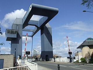
The A1206, also known as the Isle of Dogs Distributor Road, is a crescent-shaped ring road around the Isle of Dogs, in the East End of London. It is made up of Westferry Road, Manchester Road and Prestons Road and is the main road through the area, connecting parts of the London Docklands.

Coldharbour is a street and wider conservation area in Blackwall, lying on the north bank of the River Thames, east of Canary Wharf. The area is said to be "[t]he sole remaining fragment of the old hamlet of Blackwall" and "one of the last examples of the narrow streets which once characterised the river's perimeter".

