Related Research Articles

The Rural City of Swan Hill is a local government area in Victoria, Australia, located in the north-western part of the state. It covers an area of 6,115 square kilometres (2,361 sq mi) and, in August 2021, had a population of 21,403. It includes the towns of Swan Hill, Lake Boga, Manangatang, Nyah, Nyah West, Piangil, Robinvale, Ultima and Woorinen South. It was formed in 1995 from the amalgamation of the City of Swan Hill, Shire of Swan Hill and part of the Shire of Kerang.

Western Australia (WA) is divided into regions according to a number of systems.

Strathcona County is a specialized municipality in the Edmonton Metropolitan Region within Alberta, Canada between Edmonton and Elk Island National Park. It forms part of Census Division No. 11.

The Mallee is a sub-region of Loddon Mallee covering the most north-westerly part of Victoria, Australia and is bounded by the South Australian and New South Wales borders. Definitions of the south-eastern boundary vary, however, all are based on the historic Victorian distribution of mallee eucalypts. These trees dominate the surviving vegetation through most of Mallee,. Its biggest settlements are Mildura and Swan Hill.
West Mallee is a statistical subdivision defined under the Australian Standard Geographical Classification, and therefore used by the Australian Bureau of Statistics. It is one of three subdivisions of the Mallee statistical division of the Australian state of Victoria. It consists of three statistical local areas: Buloke (S) - North, Buloke (S) - South and Mildura (RC) - Pt B.
In the state of New South Wales, Australia, there are many areas which are commonly known by regional names. Regions are areas that share similar characteristics. These characteristics may be natural such as the Murray River, the coastline, or the Snowy Mountains. Alternatively, the characteristics may be cultural, such as a viticulture land use. New South Wales is divided by numerous regional boundaries, based on different characteristics. In many cases boundaries defined by different agencies are coterminous.

The Shire of Cohuna was a local government area on the Murray River, about 265 kilometres (165 mi) north-northwest of Melbourne, the state capital of Victoria, Australia. The shire covered an area of 494.69 square kilometres (191.0 sq mi), and existed from 1922 until 1995.
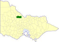
The Shire of Gordon was a local government area about 245 kilometres (152 mi) north-northwest of Melbourne, the state capital of Victoria, Australia. The shire covered an area of 2,028 square kilometres (783.0 sq mi), and existed from 1885 until 1995.
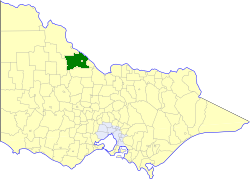
The Shire of Kerang was a local government area located in northwestern Victoria, Australia, along the Murray River. The shire covered an area of 3,254.45 square kilometres (1,256.6 sq mi), and existed from 1862 until 1995. From 1966 onwards, Kerang itself was managed by a separate entity; the Borough of Kerang.

The Shire of Swan Hill was a local government area in north-western Victoria, Australia, along the Murray River. The shire covered an area of 6,550 square kilometres (2,529.0 sq mi), and existed from 1893 until 1995. From 1939 onwards, Swan Hill itself was managed by a separate entity; the City of Swan Hill. After a large-scale statewide amalgamation program by the Victorian Government in 1994–1995, they were reunited under the Rural City of Swan Hill.

The Shire of Wycheproof was a local government area about 130 kilometres (81 mi) northwest of Bendigo in northwestern Victoria, Australia. The shire covered an area of 4,110.3 square kilometres (1,587.0 sq mi), and existed from 1894 until 1995.

The City of Swan Hill was a local government area in northwestern Victoria, Australia, along the Murray River. The city covered an area of 13.66 square kilometres (5.27 sq mi), and existed from 1939 until 1995.
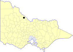
The Borough of Kerang was a local government area in north-western Victoria, Australia. The borough, which for most of its history was part of the surrounding Shire of Kerang, covered an area of 22.60 square kilometres (8.7 sq mi), and existed from 1966 until 1995.

The Shire of Ripon was a local government area about 160 kilometres (99 mi) west-northwest of Melbourne, the state capital of Victoria, Australia. The shire covered an area of 1,533 square kilometres (591.9 sq mi), and existed from 1861 until 1994.

The Murraylands is a geographical region of the Australian state of South Australia (SA); its name reflects that of the river running through it. Lying due east of South Australia's capital city, Adelaide, it extends from the eastern slopes of the Mount Lofty Ranges to the border with the state of Victoria, a distance of about 180 kilometres. The north-to-south distance is about 130 kilometres. The region's economy is centred on agriculture, and tourism, especially along its 200-kilometre (120-mile) frontage of the River Murray.
In the Australian state of Tasmania, there are many areas which are commonly known by regional names. Regions are areas that share similar characteristics. These characteristics may be natural such as the Furneaux Islands, the coastline, or the Central Highlands. Alternatively, the characteristics may be cultural, such as a viticulture land use. Tasmania is divided by numerous regional boundaries, based on different characteristics. In many cases boundaries defined by different government agencies are coterminous and are often cited by the Australian and local media that tend to distinguish between North West, West Coast, Southern, and East Coast.
In South Australia, one of the states of Australia, there are many areas which are commonly known by regional names. Regions are areas that share similar characteristics. These characteristics may be natural such as the Murray River, the coastline, desert or mountains. Alternatively, the characteristics may be cultural, such as common land use. South Australia is divided by numerous sets of regional boundaries, based on different characteristics. In many cases boundaries defined by different agencies are coterminous.
Mixx FM 107.7 is a commercial radio station broadcasting from Swan Hill, Victoria, Australia. It is currently owned by Ace Radio & broadcasts A Contemporary Hits Radio (CHR) format. It features both locally produced content & nationally syndicated content from both NOVA Entertainment & Grant Broadcasters. They have a repeater in Kerang on 98.7FM.
References
- ↑ "1216.0 - Statistical Geography Volume 1 - Australian Standard Geographical Classification (ASGC), Jul 2006". Australian Bureau of Statistics. 2006. Retrieved 26 April 2007.