
Sulawesi, also known as Celebes, is one of the four Greater Sunda Islands. It is governed by Indonesia. The world's eleventh-largest island, it is situated east of Borneo, west of the Maluku Islands, and south of Mindanao and the Sulu Archipelago. Within Indonesia, only Sumatra, Borneo and Papua are larger in territory, and only Java and Sumatra have larger populations.

The Baja California Peninsula is a peninsula in Northwestern Mexico. It separates the Pacific Ocean from the Gulf of California. The peninsula extends 1,247 km from Mexicali, Baja California in the north to Cabo San Lucas, Baja California Sur in the south. It ranges from 40 km at its narrowest to 320 km at its widest point and has approximately 3,000 km of coastline and approximately 65 islands. The total area of the Baja California Peninsula is 143,390 km2 (55,360 sq mi), roughly the same area as the country of Nepal.

South Sulawesi is a province in the southern peninsula of Sulawesi. The Selayar Islands archipelago to the south of Sulawesi is also part of the province. The capital is Makassar. The province is bordered by Central Sulawesi and West Sulawesi to the north, the Gulf of Bone and Southeast Sulawesi to the east, Makassar Strait to the west, and Flores Sea to the south.

North Sulawesi is a province of Indonesia. It is located on the Minahasa Peninsula of Sulawesi, south of the Philippines and southeast of Sabah, Malaysia. It borders Davao and Soccsksargen regions of the Philippines to the north, the Maluku Sea to the east, Gorontalo and Celebes Sea to the west and the Gulf of Tomini to the southwest. The province's area is 13851.64 sq.km, and its population was 2,270,596 according to the 2010 census; this rose to 2,409,921 at the 2015 Intermediate Census, and the latest official estimate is 2,512,900.
Southeast Sulawesi is a province on the island of Sulawesi, forming the southeastern peninsula of that island, together with a number of large offshore islands such as Buton, Muna, Kabaena and Wawonii, with smaller islands. The capital is Kendari, on the east coast of the peninsula.

The Celebes Sea of the western Pacific Ocean is bordered on the north by the Sulu Archipelago and Sulu Sea and Mindanao Island of the Philippines, on the east by the Sangihe Islands chain, on the south by Sulawesi's Minahasa Peninsula, and on the west by northern Kalimantan in Indonesia. It extends 420 miles (675 km) north-south by 520 mi (840 km) east-west and has a total surface area of 110,000 square miles (280,000 km2), to a maximum depth of 20,300 feet (6,200 m). South of the Mangkalihat Peninsula, the sea opens southwest through the Makassar Strait into the Java Sea.

The Gulf of Carpentaria is a large, shallow sea enclosed on three sides by northern Australia and bounded on the north by the eastern Arafura Sea. The northern boundary is generally defined as a line from Slade Point, Queensland in the northeast, to Cape Arnhem, Northern Territory in the west.
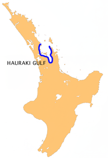
The Hauraki Gulf / Tīkapa Moana is a coastal feature of the North Island of New Zealand. It has an area of 4000 km2, and lies between, in anticlockwise order, the Auckland Region, the Hauraki Plains, the Coromandel Peninsula, and Great Barrier Island. Most of the gulf is part of the Hauraki Gulf Marine Park.
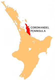
The Coromandel Peninsula on the North Island of New Zealand extends 85 kilometres north from the western end of the Bay of Plenty, forming a natural barrier to protect the Hauraki Gulf and the Firth of Thames in the west from the Pacific Ocean to the east. It is 40 kilometres wide at its broadest point. Almost the entire population lies on the narrow coastal strips fronting the Hauraki Gulf and the Bay of Plenty. In clear weather the peninsula is clearly visible from Auckland, the country's biggest city, which lies on the far shore of the Hauraki Gulf, 55 kilometres to the west. The peninsula is part of the Thames-Coromandel District of the Waikato Region.
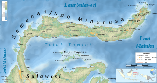
The Minahasa Peninsula, also spelled Minahassa, is one of the four principal peninsulas on the Indonesian island of Sulawesi. It stretches north from the central part of the island, before turning to the east and forming the northern boundary of the Gulf of Tomini and the southern boundary of the Celebes Sea.
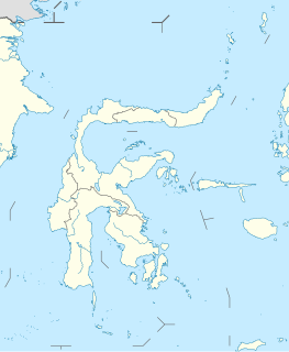
The Southeast Peninsula is a peninsula of Sulawesi (Celebes), lying between the Gulf of Tolo and the Gulf of Boni. It is mostly coterminous with the province of Southeast Sulawesi. The largest city on the peninsula is Kendari.
The South Peninsula is one of the four principal peninsulas on the island of Sulawesi, stretching south from the central part of the island. It is part of the province of South Sulawesi. The southern peninsula is the most densely populated peninsula in Sulawesi; over 45% of the population of Sulawesi are on the southern peninsula. Inhabited by an Austronesian people who came thousands of years ago. The largest ethnic group in Sulawesi is the Bugis, followed by Makassar and Toraja.

The Gulf of Tomini, also known as the Bay of Tomini, is the equatorial gulf which separates the Minahassa (Northern) and East Peninsulas of the island of Sulawesi (Celebes) in Indonesia. The Togian Islands lie near its center. To the east, it opens onto the Molukka Sea.

The Thracian Sea is a sea that is part of the Aegean Sea and forms the northernmost point of the sea. Regions surrounding the sea are Macedonia and Thrace as well as northwestern Turkey. The entire stretch of the sea lies north of the 40th parallel. The length from east to west is from 23°E to about 25.8°E or from the Strymonian Gulf east to the northernmost part of the Gallipoli peninsula and the width from north to south is about 40.25°N to 41°N or from the Dardanelles north to the boundary between the Xanthi and the Rhodope regional units. Islands includes Thasos and Samothrace in Greece and Gökçeada and Bozcaada in Turkey. The bays and gulfs includes the Ierissian Gulf to the southwest, the Strymonian Gulf where the Strymon River empties, the Kavala Gulf and the Saros Gulf in Turkey. Rivers emptying into this portion of the gulf include the Nestos and the Evros/Meriç. The famous thermal springs are Loutra Eleftheron in Kavala.

Investigator Strait is a body of water in South Australia lying between the Yorke Peninsula, on the Australian mainland, and Kangaroo Island. It was named by Matthew Flinders after his ship, HMS Investigator, on his voyage of 1801–1802. It is bordered by the Gulf St Vincent in the northeast.
The Nova Scotia peninsula is a peninsula on the Atlantic coast of North America.
A continental divide is a drainage divide on a continent such that the drainage basin on one side of the divide feeds into one ocean or sea, and the basin on the other side either feeds into a different ocean or sea, or else is endorheic, not connected to the open sea. Every continent on earth except Antarctica has at least one continental drainage divide; islands, even small ones like Killiniq Island on the Labrador Sea in Canada, may also host part of a continental divide or have their own island-spanning divide.
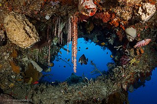
The Central Indo-Pacific is a biogeographic region of the Earth's seas, comprising the tropical waters of the western Pacific Ocean, the eastern Indian Ocean, and the connecting seas.
Sinjai Regency is a regency of South Sulawesi Province of Indonesia. The regency is separated from the Bone Regency to its north by the River Tangka. It includes the Nine Islands off the east coast of the southern peninsula of Sulawesi, a group which form a district within the regency. The regency's principal town lies at Sinjai, a port situated on the east coast of that peninsula.
