East Point, British Indian Ocean Territory

Last updated
East Point
Ghost town
DG Ariel Plantation.jpg
A view of East Point from the air
CIA-DG-BIOT.jpg
Map of Diego Garcia. East Point is annotated.
Coordinates: 07°21′12.2″S072°28′3.5″E / 7.353389°S 72.467639°E / -7.353389; 72.467639 Coordinates: 07°21′12.2″S072°28′3.5″E / 7.353389°S 72.467639°E / -7.353389; 72.467639
Country United Kingdom
Overseas territory Flag of the British Indian Ocean Territory.svg  British Indian Ocean Territory
Population
(2016)
  Total0
Time zone UTC+6 (UTC+06:00)
Former Plantation Manager's house, prior to restoration Plantation buildings used by the evicted former occupants of Diego Garcia -a.jpg
Former Plantation Manager's house, prior to restoration

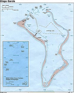
East Point is an abandoned settlement on the east of the atoll of Diego Garcia in the British Indian Ocean Territory. It was the largest civilian settlement in the archipelago, and served as the administrative capital until the depopulation of the territory. [1] [2] [3]

Diego Garcia British atoll in the Indian Ocean

Diego García is an atoll just south of the equator in the central Indian Ocean, and the largest of 60 small islands comprising the Chagos Archipelago. It was first discovered by Europeans and named by the Portuguese, settled by the French in the 1790s and transferred to British rule after the Napoleonic Wars. It was one of the "Dependencies" of the British Colony of Mauritius until it was detached for inclusion in the newly created British Indian Ocean Territory (BIOT) in 1965.

British Indian Ocean Territory Overseas territory of the United Kingdom

The British Indian Ocean Territory (BIOT) is an overseas territory of the United Kingdom situated in the Indian Ocean halfway between Tanzania and Indonesia, and directly south of the Maldives. The territory comprises the seven atolls of the Chagos Archipelago with over 1,000 individual islands – many very small – amounting to a total land area of 60 square kilometres (23 sq mi). The largest and most southerly island is Diego Garcia, 27 km2 (10 sq mi), the site of a joint military facility of the United Kingdom and the United States.

Contents

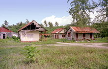
The settlement contained a church, cemetery, school, sanatorium in addition to senior management housing. [4] The settlement also contained a post office, which became the plantation warden's office. [5]

History

The settlement was one of four founded during the French rule. Originally named Pointe le Est, it originally served as a coconut plantation. [6]

Diego Garcia was ceded to the United Kingdom after the Napoleonic wars as part of the Treaty of Paris (1814). [7]

United Kingdom Country in Europe

The United Kingdom, officially the United Kingdom of Great Britain and Northern Ireland but more commonly known as the UK or Britain, is a sovereign country lying off the north-western coast of the European mainland. The United Kingdom includes the island of Great Britain, the north-eastern part of the island of Ireland and many smaller islands. Northern Ireland is the only part of the United Kingdom that shares a land border with another sovereign state‍—‌the Republic of Ireland. Apart from this land border, the United Kingdom is surrounded by the Atlantic Ocean, with the North Sea to the east, the English Channel to the south and the Celtic Sea to the south-west, giving it the 12th-longest coastline in the world. The Irish Sea lies between Great Britain and Ireland. With an area of 242,500 square kilometres (93,600 sq mi), the United Kingdom is the 78th-largest sovereign state in the world. It is also the 22nd-most populous country, with an estimated 66.0 million inhabitants in 2017.

The Treaty of Paris, signed on 30 May 1814, ended the war between France and the Sixth Coalition, part of the Napoleonic Wars, following an armistice signed on 23 April between Charles, Count of Artois, and the allies. The treaty set the borders for France under the House of Bourbon and restored territories to other nations. It is sometimes called the First Peace of Paris, as another one followed in 1815.

During World War II

In 1942, the British opened RAF Station Diego Garcia and established an advanced flying boat unit at the East Point Plantation, staffed and equipped by No 205 and No 240 Squadrons, then stationed on Ceylon. Both Catalina and Sunderland aircraft were flown during the course of World War II in search of Japanese and German submarines and surface raiders. At Cannon Point, [8] six naval guns were installed by a Royal Marines detachment. In February 1942, the mission was to protect the small Royal Navy base and Royal Air Force station located on the island from Japanese attack. [8] They were later manned by Mauritian and Indian Coastal Artillery troops. [9] Following the conclusion of hostilities, the station was closed on 30 April 1946. [10]

Consolidated PBY Catalina maritime patrol and transport flying boat

The Consolidated PBY Catalina, also known as the Canso in Canadian service, is an American flying boat, and later an amphibious aircraft of the 1930s and 1940s produced by Consolidated Aircraft. It was one of the most widely used seaplanes of World War II. Catalinas served with every branch of the United States Armed Forces and in the air forces and navies of many other nations.

Short Sunderland WWII era flying boat patrol bomber

The Short S.25 Sunderland was a British flying boat patrol bomber, developed and constructed by Short Brothers for the Royal Air Force (RAF). The aircraft took its service name from the town and port of Sunderland in Tyne and Wear, North East England.

World War II 1939–1945 global war

World War II, also known as the Second World War, was a global war that lasted from 1939 to 1945. The vast majority of the world's countries—including all the great powers—eventually formed two opposing military alliances: the Allies and the Axis. A state of total war emerged, directly involving more than 100 million people from over 30 countries. The major participants threw their entire economic, industrial, and scientific capabilities behind the war effort, blurring the distinction between civilian and military resources. World War II was the deadliest conflict in human history, marked by 50 to 85 million fatalities, most of whom were civilians in the Soviet Union and China. It included massacres, the genocide of the Holocaust, strategic bombing, premeditated death from starvation and disease, and the only use of nuclear weapons in war.

After abandonment

Abandoned buildings in the town Diego Garcia Abandoned Plantation.jpg
Abandoned buildings in the town

Originally, the British Representative resided in East Point, however later moved to the US Base. [11]

Today, the settlement lies in the eastern restricted zone of the island.

Related Research Articles

Mauritius Island nation in the Indian Ocean

Mauritius, officially the Republic of Mauritius, is an island nation in the Indian Ocean about 2,000 kilometres off the southeast coast of the African continent. The country includes the islands of Mauritius and Rodrigues, 560 kilometres east of Mauritius, and the outer islands of Agaléga and St. Brandon. The islands of Mauritius and Rodrigues form part of the Mascarene Islands, along with nearby Réunion, a French overseas department. The area of the country is 2,040 km2. The capital and largest city is Port Louis. The island is widely known as the only known home of the dodo, which, along with several other avian species, was made extinct by human activities relatively shortly after the island's settlement.

British Overseas Territories territory under the jurisdiction and sovereignty of the United Kingdom but not part of it

The British Overseas Territories (BOTs) or United Kingdom Overseas Territories (UKOTs) are 14 territories under the jurisdiction and sovereignty of the United Kingdom. They are remnants of the British Empire that have not been granted independence or have voted to remain British territories. These territories do not form part of the United Kingdom and, with the exception of Gibraltar, are not part of the European Union. Most of the permanently inhabited territories are internally self-governing, with the UK retaining responsibility for defence and foreign relations. Three are inhabited only by a transitory population of military or scientific personnel. They all share the British monarch as head of state.

Flag of the British Indian Ocean Territory State flag and ensign of the British Indian Ocean Territory

The flag of the British Indian Ocean Territory (BIOT) is similar to the flags of other British dependencies and colonies as it has the Union Flag in the upper hoist-side corner. The palm tree and crown are symbols of the Indian Ocean Territory.

Chagos Archipelago Archipelago in the Indian Ocean

The Chagos Archipelago or Chagos Islands are a group of seven atolls comprising more than 60 individual tropical islands in the Indian Ocean about 500 kilometres (310 mi) south of the Maldives archipelago. This chain of islands is the southernmost archipelago of the Chagos-Laccadive Ridge, a long submarine mountain range in the Indian Ocean.

Chagossians ethnic group

The Chagossians are people of African origin, who inhabited the Chagos Islands, specifically Diego Garcia, Peros Banhos, and the Salomon island chain, as well as other parts of the Chagos Archipelago, from the late 18th to the late 20th century. Most Chagossians now live in Mauritius and the United Kingdom after being forcibly evicted by the British government in the late 1960s and early 1970s so that Diego Garcia, the island where most Chagossians lived, could serve as the location for a United States military base. Today, no Chagossians live on the island of Diego Garcia, as it is now the site of the military base Camp Justice.

Geography of the British Indian Ocean Territory

The British Indian Ocean Territory (BIOT) is an archipelago of 55 islands in the Indian Ocean, located south of India. It is situated approximately halfway between Africa and Indonesia. The islands form a semicircular group with an open sea towards the east. The largest, Diego Garcia, is located at the southern extreme end. It measures 60 square kilometres (23 sq mi) and accounts for almost three-quarters of the total land area of the territory. Diego Garcia is the only inhabited island and is home to the joint UK-US naval support facility. Other islands within the archipelago include Danger Island, Three Brothers Islands, Nelson Island, and Peros Banhos, as well as the island groups of the Egmont Islands, Eagle Islands, and the Salomon Islands.

Eagle Islands island group

Eagle Islands is a group of two islands in the Chagos Archipelago. They are located on the central-western rim of the Great Chagos Bank, which is the world's largest coral atoll structure.

Great Chagos Bank island group

The Great Chagos Bank, in the Chagos Archipelago, about 500 km (310 mi) south of the Maldives, is the largest atoll structure in the world, with a total area of 12,642 km2 (4,881 sq mi). The atoll is administered by the United Kingdom through the British Indian Ocean Territory (BIOT).

Expulsion of the Chagossians Ethnic cleansing

The depopulation of Chagossians from the Chagos Archipelago was the forced expulsion of the inhabitants of the island of Diego Garcia and the other islands of the British Indian Ocean Territory (BIOT) by the United Kingdom, at the request of the United States, beginning in 1968 and concluding on 27 April 1973 with the evacuation of Peros Banhos atoll. The people, known at the time as the Ilois, are today known as Chagos Islanders or Chagossians.

UTC+06:00 Identifier for a time offset from UTC of +6

UTC+06:00 is an identifier for a time offset from UTC of +06:00. This time is used in:

Naval Support Facility Diego Garcia facility of the United States Navy located on Diego Garcia

Naval Support Facility Diego Garcia is a British Ministry of Defence facility leased to the United States Navy, located on the atoll Diego Garcia in the Indian Ocean.

The British Indian Ocean Territory Police serve in the British Indian Ocean Territory (BIOT).

Camp Justice (Diego Garcia) United States military base on Diego Garcia

Camp Justice is a settlement within the US-UK Naval Support Facility on Diego Garcia, a small, strategically located, isolated island in the Indian Ocean. The island is in the Chagos Archipelago, part of the British Indian Ocean Territory. United States forces have used Diego Garcia since at least the mid-1960s, under lease from the United Kingdom. The island has port facilities and an airstrip capable of handling large aircraft.

Colin Roberts (diplomat) British diplomat and Governor of the Falkland Islands

Colin Roberts CVO is a British diplomat and the former Governor of the Falkland Islands and former Commissioner of the South Georgia and the South Sandwich Islands.

Chagos Archipelago sovereignty dispute

Sovereignty over the Chagos Archipelago is disputed between Mauritius and the United Kingdom. Mauritius has repeatedly asserted that the Chagos Archipelago is part of its territory and that the United Kingdom (UK) claim is a violation of United Nations resolutions banning the dismemberment of colonial territories before independence. The UK government has stated that it has no doubt about its sovereignty over the Chagos, and has also said that the Chagos will be returned to Mauritius once the islands are no longer required for defence purposes. Given the absence of any progress with the UK, Mauritius has decided to "internationalise" the dispute and take up the matter at all appropriate legal and political forums.

The Chagos Marine Protected Area, located in the central Indian Ocean in the British Indian Ocean Territory of the United Kingdom, is one of the world's largest marine protected areas, and one of the largest protected areas of any type on Earth. It was established by the British government on 1 April 2010 as a massive, contiguous, no-take marine reserve, it encompasses 640,000 square kilometres (250,000 sq mi) of ocean waters, including roughly 70 small islands and seven atolls of the Chagos Archipelago.

The Royal Navy maintains a number of Naval Parties worldwide to support a number of operations and training activities:

References

  1. Ron Schmidt. "ECHELON US Naval Computer and Telecommunications Station Far East Detachment, Diego Garcia". thelivingmoon.com. Retrieved 2016-05-15.
  2. "History - The Chagos Archipelago". sites.google.com. Retrieved 2016-05-15.
  3. Marine Governance in the Chagos Archipelago, Richard Dunne. Bristol University . 25 September 2015
  4. "Chagos Islanders v. Attorney General".
  5. "Plantation Warden's Office". Flickr - Photo Sharing!.
  6. Ted Morris. "Diego Garcia - The Plantation". zianet.com. Retrieved 2016-05-15.
  7. Edis (2004), p. 32.
  8. 1 2 Cannon Point, Diego Garcia. 28 April 2007 via YouTube.
  9. Edis (2004), p. 73.
  10. Edis (2004), p. 70.
  11. "Seabees in the Early 1970s on Diego Garcia, BIOT".