Firesteel River is an 18.3-mile-long (29.5 km) river in Ontonagon County on the Upper Peninsula of the U.S. state of Michigan. The river flows generally northwest between the Flintsteel River and the West Sleeping River and empties into Lake Superior. Branches of the river are identified as the West Branch and East Branch, and the river receives Black Creek about three miles north of the junction of the two main branches.
The Mineral River is an 18.7-mile-long (30.1 km) tributary of Lake Superior on the western Upper Peninsula of Michigan in the United States. It flows for its entire length in western Ontonagon County, rising in the Ottawa National Forest and flowing generally northward to meet Lake Superior about 11 miles (18 km) west-southwest of Ontonagon. The United States Board on Geographic Names settled on "Mineral River" as the stream's name in 1976; according to the Geographic Names Information System it has also been known historically as "Beaver Creek".

The Presque Isle River runs 42.1 miles (67.8 km) through the Upper Peninsula of Michigan and empties into Lake Superior. Along its course, it flows through the Ottawa National Forest and Porcupine Mountains Wilderness State Park. It has 300 square miles (780 km2) of drainage area in Upper Michigan and northern Wisconsin.

The Brule River is a 52.3-mile-long (84.2 km) river in the U.S. states of Michigan and Wisconsin. Nearly the entire course forms a portion of the boundary between the two states.
Coldwater River is a 29.5-mile-long (47.5 km) stream in the U.S. state of Michigan. Located in Branch County, the river rises in Ovid Township at 41°50′14″N84°59′13″W as the outflow of Coldwater Lake. Flowing north and west, it is joined by the outflow from the Lake of the Woods and continues north for several miles. West of the city of Coldwater, it flows through a series of lakes: South Lake, Messenger Lake, Cemetery Lake, North Lake, Randall Lake, Morrison Lake, Craig Lake, and Hodunk Pond. It then continues to the northwest and empties into the St. Joseph River in the village of Union City at 42°03′58″N85°07′48″W.
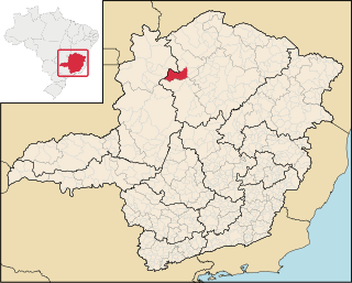
São Romão is a Brazilian municipality located in the north of the state of Minas Gerais. In 2007 the population was 9,080 in a total area of 2,432 km². It became a municipality in 1943.

Cormier Woods is a 175-acre (71 ha) open space preserve and historic 18th-century farm complex in Uxbridge, Massachusetts, USA, within the Blackstone River Valley National Heritage Corridor. The property is named for James Cormier, the former owner of the property. It was acquired in 2008 by the land conservation non-profit organization The Trustees of Reservations.

The Chocolay River is a 21.7-mile-long (34.9 km) tributary of Lake Superior in Marquette County on the Upper Peninsula of Michigan in the United States. It forms at the confluence of its West and East Branches west of Skandia and flows generally north, then west, to Lake Superior at the village of Harvey, 3 miles (5 km) southeast of the city of Marquette.
The Cliff River is a 6.8-mile-long (10.9 km) river on the Upper Peninsula of Michigan in the United States. It is a tributary of Mountain Lake, which drains by Mountain Stream to Pine Lake, which in turn drains by the Pine River to Lake Superior.
The Gogomain River is a 2.5-mile-long (4.0 km) stream in the Upper Peninsula of Michigan in the United States. It is located in Raber Township in Chippewa County and flows into Munuscong Lake, part of the St. Marys River waterway and an arm of Lake Huron.
The Hendrie River is a 30.7-mile-long (49.4 km) tributary of the Tahquamenon River on the Upper Peninsula of Michigan in the United States.
The Ogontz River is a 5.3-mile-long (8.5 km) river on the Upper Peninsula of Michigan in the United States. It is a tributary of Ogontz Bay, an arm of Big Bay de Noc on Lake Michigan.
The Pelton River is a 5.9-mile-long (9.5 km) tributary of the Slate River in Gogebic County on the Upper Peninsula of Michigan in the United States. Via the Slate River, its water flows to Lake Gogebic, which feeds the West Branch Ontonagon River, flowing to the Ontonagon River and ultimately to Lake Superior.
The West Sleeping River is an 8.5-mile-long (13.7 km) river in Ontonagon County, Michigan, in the United States. It is a tributary of Lake Superior.

Jarvie is a hamlet in central Alberta, Canada within Westlock County. It is located 0.6 kilometres (0.37 mi) west of Highway 44, approximately 108 kilometres (67 mi) northwest of Edmonton.
The Little Black River is a 19.6-mile-long (31.5 km) stream in Gogebic County in the U.S. state of Michigan. It rises in Bessemer Township at 46°21′23″N89°53′09″W} and flows mostly north to Sunday Lake in Wakefield, then westward for approximately a mile before emptying into the Black River at 46°29′18″N89°59′49″W, just north of Ramsay. The water is approximately 14 inches (360 mm) deep.

Indian River is a 59.1-mile-long (95.1 km) tributary of the Manistique River on the Upper Peninsula of Michigan in the United States. It rises out of Hovey Lake at 46°17′36″N86°42′20″W on Hiawatha National Forest land in Alger County and flows south and east through a lake district and on through Schoolcraft County. The river flows into the 8,659 acre (35 km²) Indian Lake at 46°17′36″N86°42′20″W and flows out at 45°59′30″N86°17′15″W. It then flows east and south about 2.5 miles where it merges with the Manistique River, which then flows through Manistique and into Lake Michigan at 45°56′56″N86°14′45″W.
Floodwood River is an 11.0-mile-long (17.7 km) river in Ontonagon County in the U.S. state of Michigan.
Carp River is a 10.3-mile-long (16.6 km) river in Gogebic and Ontonagon counties in the U.S. state of Michigan. The Carp River is formed by the outflow of the Lake of the Clouds at 46°48′04″N89°45′38″W in the Porcupine Mountains of the Upper Peninsula.
Little Carp River is a 15-mile-long (24 km) river in Gogebic and Ontonagon counties in the U.S. state of Michigan. The Carp River rises at 46°45′54″N89°44′44″W in the Porcupine Mountains of the Upper Peninsula.


