This page is based on this
Wikipedia article Text is available under the
CC BY-SA 4.0 license; additional terms may apply.
Images, videos and audio are available under their respective licenses.

Bridal Veil Falls is a waterfall near the town of Kagawong on Lake Huron's Manitoulin Island, Ontario, Canada. The water source is the Kagawong River which flows from Lake Kagawong to the North Channel of Lake Huron.
WCTS is a radio station licensed to Maplewood, Minnesota, and serving the Twin Cities metropolitan area with a non-commercial fundamentalist Christian format. WCTS is owned by the Central Baptist Theological Seminary of Minneapolis, hence the call letters. Studios are located in Plymouth, while its transmitter is located in Woodbury.

Doneztebe-Santesteban is a town and municipality located in the province and autonomous community of Navarre, northern Spain.
Warren is an unincorporated community recognized as a local urban district in Manitoba. It is located in the Rural Municipality of Woodlands.
São Brás is a municipality located in the Brazilian state of Alagoas. Its population was 6,700 (2005) and its area is 140 km².
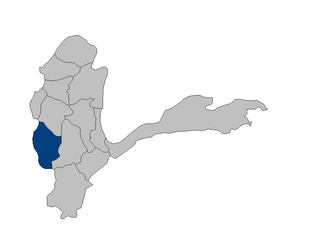
Kishim District is one of the 29 districts of Badakhshan Province in eastern Afghanistan. The district is located in the Keshem Valley, a primarily rural area on the western edge of the province, and is home to approximately 63,000 residents, making it the second most populous district of the province.

KOEL is a US radio station serving Waterloo, Cedar Falls and surrounding cities with a news/talk format. The station broadcasts on AM frequency 950 kHz and is under the ownership of Townsquare Media. Despite different owners and affiliations, KOEL and KWWL maintain a strong partnership.
Windigo First Nations Council is a non-political Chiefs Council in northwestern Ontario, Canada, serving its seven member-First Nations. The council was organized in 1983. The organization is directed by the Chiefs of the member First Nations who form the Board of Directors. Like many of the regional tribal councils, Windigo First Nations Council is a member of the Nishnawbe Aski Nation.

Patton Hill is an unincorporated community in the Indian Creek Township, of Lawrence County, Indiana.

Maziarze Stare is a village in the administrative district of Gmina Iłża, within Radom County, Masovian Voivodeship, in east-central Poland. It lies approximately 6 kilometres (4 mi) south-east of Iłża, 32 km (20 mi) south of Radom, and 123 km (76 mi) south of Warsaw.
Nowina is a village in the administrative district of Gmina Elbląg, within Elbląg County, Warmian-Masurian Voivodeship, in northern Poland. It lies approximately 7 kilometres (4 mi) north-east of Elbląg and 78 km (48 mi) north-west of the regional capital Olsztyn.

Wauchope is an unincorporated community in the southeast corner of the Canadian province of Saskatchewan. It is located between the towns of Manor and Redvers, and is situated on the Saskatchewan Highway 13. Once a thriving French language settlement in the early 20th century, the town used to have a Catholic Residential School (1917–64), a saloon, a general store, a motor repair shop, and other businesses. The town is in the rural municipality of Antler No. 61.
Mount Pleasant No. 2 is a rural municipality in the Canadian province of Saskatchewan. It is located in southeastern Saskatchewan and is within SARM Division No. 1 and Census Division No. 1. Its population was 418 as of the 2006 Census.
Lindell is an unincorporated community in Washington County, in the U.S. state of Virginia.
Colerain is an extinct town in Camden County, in the U.S. state of Georgia. The GNIS classifies it as a populated place. A variant name was "Coleraine".

Angle Tarn is a lake in Cumbria, England, about a mile north-east of Hartsop. Located at an altitude of 479 m (1,572 ft), the lake has an area of 5.9 hectares, measures 385 by 260 m, with a maximum depth of 9 m (30 ft). The lake is very distinctive in that it resembles a fish hook in shape. It contains ‘two rocky islets and a small broken peninsula’.
Baker Inlet is an inlet in the North Coast region of British Columbia, Canada, extending east from Grenville Channel opposite Pitt Island, to the south of Kumealon Inlet.
Eames is an unincorporated community in Skelton Township, Warrick County, in the U.S. state of Indiana.